
Napa County is a county north of San Pablo Bay in the northern portion of the U.S. state of California. As of the 2010 census, the population was 136,484. The county seat is the City of Napa. Napa County was one of the original counties of California, created in 1850 at the time of statehood. Parts of the county's territory were given to Lake County in 1861.

Union County is a county located in the southern part of the U.S. state of Iowa. As of the 2010 census, the population was 12,534. The county seat is Creston. Organized at a time of tensions before the Civil War, the county was named in 1853 for the union that people wanted to preserve. The rural county's peak of population was in 1930. Its economy is based on agriculture and related industries. Creston and the county are still served by the Burlington Northern Santa Fe Railroad (BNSF), the largest network in the nation.

Napa is the largest city and the county seat of Napa County. It is the principal city of the Napa County Metropolitan Statistical Area, with a population of 76,915 as of the 2010 census. It is the second-largest city in California's Wine Country, after Santa Rosa. Napa was incorporated as a city in 1872.

Wine Country is the region of California, in the northern Bay Area, known worldwide as a premier wine-growing region. The region is famed for its wineries, its cuisine, Michelin star restaurants, boutique hotels, luxury resorts, historic architecture, and culture. Viticulture and wine-making have been practiced in the region since the Spanish missionaries from Mission San Francisco Solano established the first vineyards in 1812.

Bale Grist Mill State Historic Park is a California state park located in Napa County between St. Helena and Calistoga. The park is the site of a water-powered grist mill that was built in 1846 is one of only two water-driven mills remaining west of the Mississippi River.

The Napa River is a river approximately 55 miles (89 km) long in the U.S. state of California. It drains a famous wine-growing region called the Napa Valley, in the mountains north of the San Francisco Bay. Milliken Creek and Mt. Veeder watersheds are a few of its many tributaries. The river mouth is at Vallejo, where the intertidal zone of fresh and salt waters flow into the Carquinez Strait and the San Pablo Bay.

The North Bay is a subregion of the San Francisco Bay Area, in California, United States. The largest city is Santa Rosa, which is the fifth-largest city in the Bay Area. It is the location of the Napa and Sonoma wine regions, and is the least populous and least urbanized part of the Bay Area. It consists of Marin, Napa, Solano and Sonoma counties.

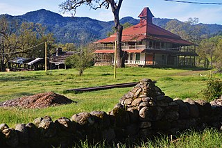
Bothe-Napa Valley State Park is a state park of California in the United States. Located in the Napa Valley, it contains the farthest inland coast redwoods in a California state park. The 1,991-acre (806 ha) park was established in 1960.
Napa Valley AVA is an American Viticultural Area located in Napa County in California's Wine Country. Napa Valley is considered one of the premier wine regions in the world. Records of commercial wine production in the region date back to the nineteenth century, but premium wine production dates back only to the 1960s.

KVON is a commercial AM radio station broadcasting a sports radio format. Licensed to Napa, California, it serves the Napa County/Sonoma County region of Northern California. The station is owned by Wilfred Alexander Marcencia and Julissa Marcencia, through licensee Wine Down Media LLC, and features programming provided by Fox Sports Radio and Premiere Networks.
Aetna Springs is an unincorporated community in Napa County, California, United States. It lies at an elevation of 771 feet. The ZIP Code is 94567. The community is inside area code 707.

This is a list of the National Register of Historic Places listings in Napa County, California.

The 1988 United States presidential election in California took place on November 8, 1988, and was part of the 1988 United States presidential election. Voters chose 47 representatives, or electors to the Electoral College, who voted for president and vice president.

Creston is a city in, and the county seat of, Union County, Iowa, United States. The population was 7,834 at the 2010 census.

Creston is a census-designated place in San Luis Obispo County, California, about 10 miles east of Atascadero.

Cuttings Wharf is an unincorporated community in Napa County, California. It lies at an elevation of 7 feet. Cuttings Wharf is located on the Napa River, 4 miles (6.4 km) northwest of Napa Junction.

The 2014 South Napa earthquake occurred in the North San Francisco Bay Area on August 24 at . At 6.0 on the moment magnitude scale and with a maximum Mercalli intensity of VIII (Severe), the event was the largest in the San Francisco Bay Area since the 1989 Loma Prieta earthquake. The epicenter of the earthquake was located to the south of Napa and to the northwest of American Canyon on the West Napa Fault.

The Atlas Fire was a 2017 wildfire burning in Napa County, California north of the city of Napa, near Napa Soda Springs. It was one of fourteen large fires simultaneously burning in eight Northern California counties, in what was called the "Northern California firestorm". Governor Jerry Brown declared a state of emergency.

The Glass Fire was a wildfire in Northern California, that started on September 27, 2020, at 3:48 AM (PDT) from an undetermined cause and was active for 23 days. It was considered to be part of the 2020 California Wildfires and the 2020 Western United States wildfire season. The fire was named due to its origin nearby Glass Mountain Road in Deer Park, Napa County, and it extended also into Sonoma County. Initially a single 20-acre brush fire, it rapidly grew and merged with two smaller fires that expanded to 11,000 acres during the night of September 27 into September 28.


