Cartwright, Oklahoma

Last updated

Cartwright, Oklahoma
Cartwright, Oklahoma.jpg
United States Postal Service post office - Cartwright, Oklahoma.jpg
Texoma Inn - Cartwright, Oklahoma.jpg
Top to bottom, left to right:
Viewing east on Oklahoma State Highway 91 in Cartwright, the city's United States Postal Service post office, and the Texoma Inn
Coordinates: 33°51′20″N96°33′40″W / 33.85556°N 96.56111°W / 33.85556; -96.56111
Country Flag of the United States.svg United States
State Flag of Oklahoma.svg Oklahoma
County Bryan
Area
  Total2.371 sq mi (6.14 km2)
  Land2.37 sq mi (6.1 km2)
  Water0.01 sq mi (0.03 km2)
Elevation
[1]
666 ft (203 m)
Population
 (2010)
  Total609
Time zone UTC-6 (Central (CST))
  Summer (DST) UTC-5 (CDT)
ZIP code
74731
Area code 580
GNIS feature ID2629910 [1]

Cartwright is an unincorporated rural community and census-designated place in Bryan County, Oklahoma, United States. As of the 2010 census it had a population of 609. [2] The post office opened April 25, 1940, and it is one of the newest communities in Bryan County. The ZIP code is 74731.

Contents

It is named for Congressman Wilburn Cartwright. Cartwright was established because of the construction of Denison Dam when a community of shelters for workmen was erected.
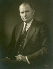
Wilburn Cartwright Wilburn Cartwright.jpg
Wilburn Cartwright

Overview

In Cartwright for the years 2010–2014, the median household income is $27,212 and the median house value is $101,500. The median year that a house in Cartwright was built is 1983. Cartwright's population density is 267.77 inhabitants per square mile (103.39/km2); whites make up 78.49% of the total population. The average temperature of Cartwright is 62.50 °F (16.94 °C). [3]

Related Research Articles

<span class="mw-page-title-main">Bryan County, Oklahoma</span> County in Oklahoma, United States

Bryan County is a county in the U.S. state of Oklahoma. As of the 2020 census, the population was 46,067. Its county seat is Durant. It is the only county in the United States named for Democratic politician William Jennings Bryan.

<span class="mw-page-title-main">Atoka County, Oklahoma</span> County in Oklahoma, United States

Atoka County is a county located in the U.S. state of Oklahoma. As of the 2020 census, the population was 14,143. Its county seat is Atoka. The county was formed before statehood from Choctaw Lands, and its name honors a Choctaw Chief named Atoka. The county is part of Choctaw Nation reservation lands.

<span class="mw-page-title-main">Van Buren Township, Michigan</span> American township in Michigan

Van Buren Charter Township, officially the Charter Township of Van Buren, is a charter township of Wayne County in the U.S. state of Michigan. The population was 28,821 at the 2010 census.

<span class="mw-page-title-main">Goltry, Oklahoma</span> Town in Oklahoma, United States

Goltry is a town in Alfalfa County, Oklahoma, United States. The population was 249 at the 2010 census. Goltry shares the Timberlake school district with the nearby towns of Helena, Jet, and Nash.

<span class="mw-page-title-main">Watonga, Oklahoma</span> City in Oklahoma, United States

Watonga is a city in Blaine County, Oklahoma. It is 70 miles northwest of Oklahoma City. The population was 5,111 at the 2010 census. It is the county seat of Blaine County.

<span class="mw-page-title-main">Armstrong, Oklahoma</span> Town in Oklahoma, United States

Armstrong is a town in Bryan County, Oklahoma, United States, along the Blue River. The population was 105 at the 2010 census, a 25.2 percent decrease from the figure of 141 recorded in 2000. The town was named for Frank C. Armstrong, a member of the Dawes Commission.

<span class="mw-page-title-main">Durant, Oklahoma</span> City in Oklahoma, United States

Durant is a city in Bryan County, Oklahoma, United States that serves as the headquarters of the Choctaw Nation of Oklahoma. The population was 18,589 in the 2020 census. Durant is the principal city of the Durant Micropolitan Statistical Area, which had a population of 46,067 in 2020. The city is the largest in the Choctaw Nation, ranking ahead of McAlester and Poteau. Durant is also part of the Dallas–Fort Worth Combined Statistical Area, anchoring the northern edge.

<span class="mw-page-title-main">Kemp, Oklahoma</span> Town in Oklahoma, United States

Kemp is a town in Bryan County, Oklahoma, United States. The population was 133 at the 2010 census, a decrease of 7.8 percent from the total of 144 recorded in 2000.

<span class="mw-page-title-main">Yukon, Oklahoma</span> City in Oklahoma, United States

Yukon is a city in eastern Canadian County, Oklahoma, United States. It is part of the Oklahoma City Metropolitan Area. The population was 22,709 at the 2010 census. Founded in the 1890s, the town was named in reference to a gold rush in Yukon Territory, Canada, at the time. Historically, Yukon served as an urban center for area farmers and the site of a large milling operation. It is now considered primarily a residential community for people who work in Oklahoma City.

<span class="mw-page-title-main">Lone Grove, Oklahoma</span> City in Oklahoma, United States

Lone Grove is a city in Carter County, Oklahoma, United States. The population was 5,054 at the 2010 census. It is part of the Micropolitan Statistical Area of Ardmore.

<span class="mw-page-title-main">Briggs, Oklahoma</span> Census-designated place in Oklahoma, United States

Briggs is an unincorporated community and census-designated place (CDP) in Cherokee County, Oklahoma, United States. The population was 303 at the 2010 census.

<span class="mw-page-title-main">Eldon, Oklahoma</span> Census-designated place in Oklahoma, United States

Eldon is an unincorporated community and census-designated place (CDP) in Cherokee County, Oklahoma, United States. The population was 368 at the 2010 census, a loss of 62.3 percent from 991 at the 2000 census, due largely to shrinkage of the CDP boundaries. It lies east of Tahlequah at the junction of U.S. Highway 62 and State Highway 51. The Eldon Post Office existed from March 20, 1911, until May 30, 1936. The community is said to have been named for Eldon, Illinois.

<span class="mw-page-title-main">Swink, Oklahoma</span> Census-designated place in Oklahoma, United States

Swink is an unincorporated community and census-designated place (CDP) in Choctaw County, Oklahoma, United States. As of the 2010 census the population was 66. The population was 83 at the 2000 census, at which time it was a town; the community disincorporated on December 1, 2000.

<span class="mw-page-title-main">Kingfisher, Oklahoma</span> City in Oklahoma, United States

Kingfisher is a city in and the county seat of Kingfisher County, Oklahoma,. The population was 4,903 at the time of the 2020 census. It is the former home and namesake of Kingfisher College. According to the Encyclopedia of Oklahoma History and Culture, Kingfisher is now primarily a bedroom community for people employed in Enid and Oklahoma City.

<span class="mw-page-title-main">Albion, Oklahoma</span> Town in Oklahoma, United States

Albion is a town in northeast Pushmataha County, Oklahoma, United States, approximately 2 miles (3.2 km) south of the Pushmataha-Latimer county line. The population was 106 at the 2010 census. When Albion was established, before Oklahoma became a state, the community was located in Wade County, Choctaw Nation, in what was then known as Indian Territory.

<span class="mw-page-title-main">Conway, South Carolina</span> City in South Carolina, United States

Conway is a city in Horry County, South Carolina. The population was 24,849 at the 2020 census, up from 17,103 in 2010 census. It is the county seat of Horry County and is part of the Myrtle Beach metropolitan area. It is the home of Coastal Carolina University.

Grant is an unincorporated community in Choctaw County, Oklahoma, United States. It is located along U.S. Route 271, south of Hugo. As of the 2010 census it had a population of 289.

<span class="mw-page-title-main">Gouldsboro, Pennsylvania</span> Village in Pennsylvania, United States

Gouldsboro is a village and census-designated place (CDP) in Lehigh Township in Wayne County, and Coolbaugh Township, in Monroe County, Pennsylvania, United States. The CDP's population was 750 at time of the 2020 United States Census.

<span class="mw-page-title-main">Sparrowhawk, Oklahoma</span> Census-designated place in Oklahoma, United States

Sparrowhawk is an unincorporated community and census-designated place (CDP) in Cherokee County, Oklahoma, United States. The population was 191 as of the 2010 census, at which time the CDP was known as Scraper. The older name of the community was given for Captain Archibald Scraper of the 2nd Regiment, Indian Home Guard. Sparrowhawk takes its name from Sparrow Hawk Mountain, which occupies most of the CDP.

Blue is an unincorporated community and census-designated place in Bryan County, Oklahoma, United States. It is located 9 miles (14 km) east of Durant, the county seat. It is named after the nearby Blue River. As of the 2010 census it had a population of 195. Its post office was established on July 1, 1874.

References

  1. 1 2 U.S. Geological Survey Geographic Names Information System: Cartwright, Oklahoma
  2. "Geographic Identifiers: 2010 Demographic Profile Data (G001): Cartwright CDP, Oklahoma". U.S. Census Bureau, American Factfinder. Archived from the original on February 12, 2020. Retrieved February 24, 2014.
  3. "USA.com Basic Information about Cartwright, Oklahoma". USA.com. Retrieved January 24, 2018.

Further reading