Hendrix, Oklahoma

Last updated

Hendrix, Oklahoma
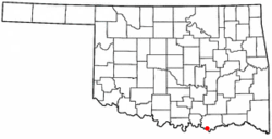
OKMap-doton-Hendrix.PNG
Location of Hendrix, Oklahoma
Coordinates: 33°46′31″N96°24′26″W / 33.77528°N 96.40722°W / 33.77528; -96.40722
Country United States
State Oklahoma
County Bryan
Area
[1]
  Total0.12 sq mi (0.31 km2)
  Land0.12 sq mi (0.31 km2)
  Water0.00 sq mi (0.00 km2)
Elevation
[2]
587 ft (179 m)
Population
 (2020)
  Total61
  Density512.61/sq mi (198.42/km2)
Time zone UTC-6 (Central (CST))
  Summer (DST) UTC-5 (CDT)
ZIP code
74741
Area code 580
FIPS code 40-33600 [3]
GNIS feature ID2412744 [2]

Hendrix is a town in Bryan County, Oklahoma, United States. The population was 79 at both the 2010 and the 2000 censuses. [4] According to the Bryan County Genealogy Society, Hendrix was originally known as Kemp City. This led to it often being confused with the neighboring town that is simply named Kemp. Hendrix was largely destroyed by a 1916 tornado.

Contents

History

Hendrix was named for the owner of a general store named James A. Hendrix. originally called Kemp City when the Missouri, Oklahoma and Gulf Railway (MO&G) bypassed the town of Kemp in 1908 while building a line to Texas. In 1910, residents petitioned the Oklahoma Corporation Commission to force the MO&G to build a side track and stop station called Kemp City at present-day Hendrix. The commission ordered the railroad to satisfy the request, but the MO&G appealed to the Oklahoma Supreme Court, which upheld the commission in 1911. [5]

Geography

According to the United States Census Bureau, the town has a total area of 0.1 square miles (0.26 km2), all land.

Demographics

Historical population
CensusPop.Note
1920 130
1930 84−35.4%
1940 14572.6%
1950 1524.8%
1960 142−6.6%
1970 117−17.6%
1980 106−9.4%
1990 1081.9%
2000 79−26.9%
2010 790.0%
2020 61−22.8%
U.S. Decennial Census [6]

As of the census [3] of 2000, there were 79 people, 32 households, and 24 families residing in the town. The population density was 650.2 inhabitants per square mile (251.0/km2). There were 38 housing units at an average density of 312.7 per square mile (120.7/km2). The racial makeup of the town was 65.82% White, 17.72% African American, 7.59% Native American, and 8.86% from two or more races.

There were 32 households, out of which 25.0% had children under the age of 18 living with them, 56.3% were married couples living together, 21.9% had a female householder with no husband present, and 21.9% were non-families. 21.9% of all households were made up of individuals, and 3.1% had someone living alone who was 65 years of age or older. The average household size was 2.47 and the average family size was 2.76.

In the town, the population was spread out, with 22.8% under the age of 18, 1.3% from 18 to 24, 30.4% from 25 to 44, 27.8% from 45 to 64, and 17.7% who were 65 years of age or older. The median age was 42 years. For every 100 females, there were 125.7 males. For every 100 females age 18 and over, there were 110.3 males.

The median income for a household in the town was $15,750, and the median income for a family was $16,563. Males had a median income of $21,250 versus $13,750 for females. The per capita income for the town was $9,378. There were 34.8% of families and 31.1% of the population living below the poverty line, including 36.4% of under eighteens and 15.4% of those over 64.

Related Research Articles

<span class="mw-page-title-main">Bryan County, Oklahoma</span> County in Oklahoma, United States

Bryan County is a county in the U.S. state of Oklahoma. As of the 2020 census, the population was 46,067. Its county seat is Durant. It is the only county in the United States named for Democratic politician William Jennings Bryan.

<span class="mw-page-title-main">Canton, Oklahoma</span> Town in Oklahoma, United States

Canton is a town in Blaine County, Oklahoma, United States. The population was 625 at the 2010 census.

<span class="mw-page-title-main">Hitchcock, Oklahoma</span> Town in Oklahoma, United States

Hitchcock is a town in Blaine County, Oklahoma, United States. The population was 121 at the 2010 census.

<span class="mw-page-title-main">Bennington, Oklahoma</span> Town in Oklahoma, United States

Bennington is a town in Bryan County, Oklahoma, United States. The population was 334 at the 2010 census.

<span class="mw-page-title-main">Kemp, Oklahoma</span> Town in Oklahoma, United States

Kemp is a town in Bryan County, Oklahoma, United States. The population was 133 at the 2010 census, a decrease of 7.8 percent from the total of 144 recorded in 2000.

<span class="mw-page-title-main">Kenefic, Oklahoma</span> Town in Oklahoma, United States

Kenefic is a town in Bryan County, Oklahoma, United States. The population was 196 at the 2010 census, a 2 percent increase from the total of 192 recorded in 2000. The town was named for William Kenefick, president of the Missouri, Oklahoma and Gulf Railroad (MO&G), which had constructed a rail line through the region. The town name has been spelled both Kenefic and Kenefick throughout its history.

<span class="mw-page-title-main">Hunter, Oklahoma</span> Town in Oklahoma, United States

Hunter is a town in Garfield County, Oklahoma, United States. The population was 165 at the 2010 census, a 4.6 percent decline from the figure of 173 in 2000.

<span class="mw-page-title-main">Norge, Oklahoma</span> Town in Oklahoma, United States

Norge is a town in Grady County, Oklahoma, United States. The population was 129 at the 2020 census, a 11% decrease from 2010.

<span class="mw-page-title-main">Elmer, Oklahoma</span> Town in Oklahoma, United States

Elmer is a town in Jackson County, Oklahoma, United States. The population was 96 at the 2010 census.

<span class="mw-page-title-main">Kendrick, Oklahoma</span> Town in Oklahoma, United States

Kendrick is a town in Lincoln County, Oklahoma, United States. The population was 139 at the 2010 census.

<span class="mw-page-title-main">Cole, Oklahoma</span> Town in Oklahoma, United States

Cole is a town in McClain County, Oklahoma, United States. The population was 624 at the 2020 census, up from 555 at the 2010 census.

<span class="mw-page-title-main">Rosedale, Oklahoma</span> Town in Oklahoma, United States

Rosedale is a town in McClain County, Oklahoma, United States. The population was 62 at the 2020 census, a 8.8% decrease from 2010.

<span class="mw-page-title-main">Hickory, Oklahoma</span> Town in Oklahoma, United States

Hickory is a town in Murray County, Oklahoma, United States. The population was 87 at the 2000 census.

<span class="mw-page-title-main">Grainola, Oklahoma</span> Town in Oklahoma, United States

Grainola is a town in northwest Osage County, Oklahoma, United States. The population was 31 at the 2010 census, a figure which was unchanged from 2000. The main industry of the area is cattle ranching. The town name was invented in March 1910.

<span class="mw-page-title-main">Optima, Oklahoma</span> Town in Oklahoma, United States

Optima is a town in Texas County, Oklahoma, United States. The population was 356 at the 2010 census.

<span class="mw-page-title-main">Porter, Oklahoma</span> Town in Oklahoma, United States

Porter is a town in Wagoner County, Oklahoma, United States. It promotes itself as "The Peach Capital of Oklahoma." The population was 566 at the 2010 census, a loss of 1.4 percent, compared to 574 at the 2000 census.

<span class="mw-page-title-main">Chesapeake, West Virginia</span> Town in West Virginia, United States

Chesapeake is a town in Kanawha County, West Virginia, United States. The population was 1,336 at the 2020 census. The town is situated on the Kanawha River. Chesapeake was incorporated on November 1, 1948 as recorded in Book 67 Page 123-124, and named for the Chesapeake and Ohio Railway, which has served the community since 1873. It is also the hometown of NFL player Chris Massey, long snapper for the St. Louis Rams. The current Mayor of Chesapeake is Paul Bradshaw.

<span class="mw-page-title-main">Worthington, West Virginia</span> Town in West Virginia, United States

Worthington is a town in Marion County, West Virginia, United States. The population was 158 at the 2010 census. Worthington was incorporated in 1893 and named for Colonel George Worthington, an early settler. U.S. Route 19 passes through the town.

<span class="mw-page-title-main">Chattanooga, Oklahoma</span> Town in Oklahoma, United States

Chattanooga is a town in Comanche and Tillman counties in the U.S. state of Oklahoma. It is located on Oklahoma State Highway 36 about 23.7 driving miles southwest of Lawton. The population was 461 at the 2010 census. The Comanche County portion of Chattanooga is included in the Lawton, Oklahoma Metropolitan Statistical Area.

<span class="mw-page-title-main">Fair Oaks, Oklahoma</span> Town in Oklahoma, United States

Fair Oaks is a town in Rogers and Wagoner counties in the U.S. state of Oklahoma. The population was 103 at the 2010 census, a 15.6 percent decline from the figure of 122 recorded in 2000. It is a suburb of Tulsa.

References

  1. "ArcGIS REST Services Directory". United States Census Bureau. Retrieved September 20, 2022.
  2. 1 2 U.S. Geological Survey Geographic Names Information System: Hendrix, Oklahoma
  3. 1 2 "U.S. Census website". United States Census Bureau . Retrieved January 31, 2008.
  4. CensusViewer:Hendrix, Oklahoma Population
  5. O'Dell, Larry. "Hendrix," Encyclopedia of Oklahoma History and Culture, Oklahoma Historical Society, 2009. Accessed April 15, 2015.
  6. "Census of Population and Housing". Census.gov. Retrieved June 4, 2015.