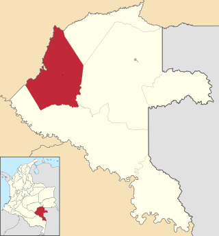
Vaupés is a department of Southeastern Colombia in the jungle covered Amazonía Region. It is located in the southeast part of the country, bordering Brazil to the east, the department of Amazonas to the south, Caquetá to the west, and Guaviare, and Guainía to the north; covering a total area of 54,135 km2. Its capital is the town of Mitú. As of 2018, the population was 40,797, making it the least populous department in Colombia.

Mitú is the capital town of the department of Vaupés in Colombia. It is a small town located in South eastern Colombia in the Amazon Basin. Founded in 1936, Mitú lies next to the Vaupés River at 180 meters above sea level. It is where the core of the services are provided to the Vaupés Department.

Amazonía region in southern Colombia comprises the departments of Amazonas, Caquetá, Guainía, Guaviare, Putumayo and Vaupés, and covers an area of 483,000 km2, 35% of Colombia's total territory. The region is mostly covered by tropical rainforest, or jungle, which is a part of the greater Amazon rainforest.

Carurú is a town and municipality located in the department of Vaupés, Colombia. The town is on the north bank of the Vaupés River in the Amazon natural region of the country.
Gerardo Tobar López Airport is an airport serving the Pacific coastal port of Buenaventura in the Valle del Cauca Department of Colombia. The runway is 6 kilometres (3.7 mi) south of the city.
La Pedrera Airport is an airport serving the Caquetá River town of La Pedrera in the Amazonas Department of southern Colombia.
La Macarena Airport, also known as El Refugio Airport, is an airport serving the Guayabero River town of La Macarena in the Meta Department of Colombia.
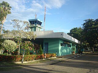
Fabio Alberto León Bentley Airport is an airport serving Mitú in the Vaupés Department of Colombia. It is next to the Vaupés River and runs along the entire length of the city.

Santiago Vila Airport is an airport serving Girardot, a city in the Cundinamarca Department of Colombia. The airport is 3.1 kilometres (2 mi) south of Girardot, across the Magdalena River by the town of Flandes in the Tolima Department.
The Taraira River (Traíra) is a river forms part of the boundary of Colombia and Brazil. It is part of the Amazon River basin.
Orocue Airport is an airport serving Orocué, a town and municipality in the Casanare Department of Colombia. The runway is adjacent to the western edge of the town, north of the Meta River.
Urrao Airport is an airport serving Urrao, a town in the Antioquia Department of Colombia. The runway and town are in an elevated mountain valley on the eastern bank of the small Penderisco River, an eventual tributary of the Atrato River.
Tarapacá Airport is an airport serving Tarapacá, a town and municipality in the Amazonas Department of Colombia. The town is on the west bank of the Putumayo River, 4 kilometres (2.5 mi) from the Brazilian border. The runway is just west of the town.
Taraira Airport is an airport serving the town of Taraira in the Vaupés Department of Colombia. The runway is adjacent to and running southwest from the town. The town and airport are 4 kilometres (2.5 mi) west of the Brazilian border.
Miraflores Airport is an airport serving the town of Miraflores, in the Guaviare Department of Colombia. The runway and town are on the east bank of the Vaupés River, a tributary of the Rio Negro River.
Cravo Norte Airport is an airport serving the Casanare River town of Cravo Norte in the Arauca Department of Colombia.
Barranco Minas Airport is an airport serving the river town of Barranco Minas in the Guainía Department of Colombia.
El Troncal Airport is an airport serving the river town of Arauquita in the Arauca Department of Colombia. The runway is 4 kilometres (2.5 mi) east of Arauquita, adjacent to the Arauca River. East departures cross the river into Venezuela.
Tapurucuara Airport is an airport serving the Querari River village of Tapurucuara in the Vaupés Department of Colombia.
Tiquie Airport is an airport serving Tiquié, a village in the Vaupés Department of Colombia. The runway is inside the village, which is on the upper reaches of the Tiquié River (sv). Tiquié is 14 kilometres (9 mi) west of the border with Brazil.


