History
In the early 19th century, it was known locally as Bledsoe's Lick, and was the location of Bledsoe's Station, a fortified trading post. As of the 2010 census, its population was 556. [4]
Native American history
During the Mississippian culture period of prehistory, the Castalian Springs Mound Site was a major local earthwork mound center, built and occupied from about 950 into the 14th century. The Native Americans who built and occupied the complex site preceded the historic tribes later known to European-American settlers in the area. This was one of the sites constructed throughout the Mississippi Valley and its tributaries, connecting regions from the Great Lakes to the Gulf of Mexico.
The site was first excavated in the 1890s. It was excavated professionally in the 2005 to 2010 archaeological field school led by Dr. Kevin E. Smith from Middle Tennessee State University. A number of important finds have been associated with the site, most particularly several examples of Mississippian stone statuary and the "Castalian Springs shell gorget," now held by the National Museum of the American Indian. [5]
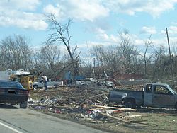
2008 Super Tuesday tornado
In the 2008 Super Tuesday tornado outbreak of February 5–6, the tiny village was hit by a strong tornado (an EF3) that claimed seven lives. The historic structure Wynnewood was heavily damaged by the storm and the United States post office was destroyed. [6] Castalian Springs captured national news headlines when an 11-month-old boy, Kyson Stowell, was found alive in the debris of his house. Originally thought to be a children's doll, the boy moved just slightly and rescuer, David Harmon, noticed the movement. He had been blown 150 yards from the house. Kyson's mother had shielded him but died in the storm. [7]
This page is based on this
Wikipedia article Text is available under the
CC BY-SA 4.0 license; additional terms may apply.
Images, videos and audio are available under their respective licenses.