Castile or Castille is a territory of imprecise limits located in Spain.

The University of Seville is a university in Seville, Andalusia, Spain. Founded under the name of Colegio Santa María de Jesús in 1505, in 2022 it has a student body of 57,214, and is ranked 6th among Spanish universities.

El Dorado is commonly associated with the legend of a gold city, kingdom, or empire purportedly located somewhere in the Americas. Originally, El Hombre Dorado or El Rey Dorado, was the term used by the Spanish in the 16th century to describe a mythical tribal chief (zipa) or king of the Muisca people, an indigenous people of the Altiplano Cundiboyacense of Colombia, who as an initiation rite, covered himself with gold dust and submerged himself in Lake Guatavita.

San Luis is a province of Argentina located near the geographical center of the country. Neighboring provinces are, from the north clockwise, La Rioja, Córdoba, La Pampa, Mendoza and San Juan.

Departments of Colombia refer to the administrative divisions of Colombia. As of 2024, the unitary republic is made up of thirty-two departments. Each department has a governor and an assembly, elected by popular vote for a four-year period.

Ferrol is a city in the province of A Coruña in Galicia, Spain. It is located in the Rías Altas, in the vicinity of Strabo's Cape Nerium. According to the 2021 census, the city has a population of 64,785, making it the seventh largest settlement in Galicia. With Eume to the south and Ortegal the north, Ferrol forms the comarca of Ferrolterra, and together with A Coruña forms the second largest conurbation in Galicia, with a total population of 640,000 in 2016.
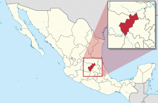
Querétaro is a state in North Central Mexico, divided into 18 municipalities. According to the 2020 Mexican census, it is the twenty-first most populated state out of thirty-two with 2,368,467 inhabitants and the sixth smallest by land area spanning 11,690.6 square kilometres (4,513.8 sq mi). The largest municipality by population is Querétaro, with 1,049,777 residents, while the smallest is San Joaquín with 8,359 residents. The largest municipality by land area is Cadereyta de Montes, with an area of 1,347.40 km2 (520.23 sq mi), and the smallest is Corregidora with 234.90 km2 (90.70 sq mi). The newest municipalities are Ezequiel Montes, Pedro Escobedo and San Joaquín, established in 1941.

Juan Manuel de Ayala y Aranza was a Spanish Navy officer who played a significant role in the European exploration of California, as he and the crew of his ship San Carlos were the first Europeans known to have entered the San Francisco Bay, having sailed there from the Port of San Blas, Nayarit, Mexico.

Zafra is a town in the Province of Badajoz, and the capital of the comarca of Zafra - Río Bodión. It has a population of 16,677, according to the 2011 census.

Toqui is a title conferred by the Mapuche on those chosen as leaders during times of war. The toqui is chosen in an assembly or parliament (coyag) of the chieftains (loncos) of various clans (Rehues) or confederation of clans (Aillarehues), allied during the war at hand. The toqui commanded strict obedience of all the warriors and their loncos during the war, would organize them into units and appoint leaders over them. This command would continue until the toqui was killed, abdicated (Cayancaru), was deposed in another parliament, or upon completion of the war for which he was chosen.

The Instituto Nacional de Estadística is the official agency in Spain that collects statistics about demography, economy, and Spanish society. It is an autonomous organization responsible for overall coordination of statistical services of the General State Administration in monitoring, control and supervision of technical procedures. Every 10 years, this organization conducts a national census. Through the official website one can follow all the updates of different fields of study.

The National Institute of Statistics and Geography is an autonomous agency of the Mexican Government dedicated to coordinate the National System of Statistical and Geographical Information of the country. It was created on January 25, 1983, by presidential decree of Miguel de la Madrid.
Bruno de Heceta (Hezeta) y Dudagoitia (1743–1807) was a Spanish Basque explorer of the Pacific Northwest. Born in Bilbao of an old Basque family, he was sent by the viceroy of New Spain, Antonio María Bucareli y Ursúa, to explore the area north of Alta California in response to information that there were colonial Russian settlements there.

During the Age of Discovery, the Spanish Empire undertook several expeditions to the Pacific Northwest of North America. Spanish claims to the region date to the papal bull of 1493, and the Treaty of Tordesillas signed in 1494. In 1513, this claim was reinforced by Spanish explorer Vasco Núñez de Balboa, the first European to sight the Pacific Ocean, when he claimed all lands adjoining this ocean for the Spanish Crown. Spain only started to colonize the claimed territory north of present-day Mexico in the 18th century, when it settled the northern coast of Las Californias.

Hispania was the Roman name for the Iberian Peninsula. Under the Roman Republic, Hispania was divided into two provinces: Hispania Citerior and Hispania Ulterior. During the Principate, Hispania Ulterior was divided into two new provinces, Baetica and Lusitania, while Hispania Citerior was renamed Hispania Tarraconensis. Subsequently, the western part of Tarraconensis was split off, initially as Hispania Nova, which was later renamed "Callaecia". From Diocletian's Tetrarchy onwards, the south of the remainder of Tarraconensis was again split off as Carthaginensis, and all of the mainland Hispanic provinces, along with the Balearic Islands and the North African province of Mauretania Tingitana, were later grouped into a civil diocese headed by a vicarius. The name Hispania was also used in the period of Visigothic rule. The modern place names of Spain and Hispaniola are both derived from Hispania.
Sierras de las Estancias y los Filabres is a Spanish geographical indication for Vino de la Tierra wines located in the autonomous region of Andalusia. Vino de la Tierra is one step below the mainstream Denominación de Origen indication on the Spanish wine quality ladder.


