Setúbal is a city and a municipality in Portugal. The population of the entire municipality in 2014 was 118,166, occupying an area of 230.33 km2 (88.9 sq mi). The city itself had 89,303 inhabitants in 2001. It lies within the Lisbon metropolitan area, about 50 kilometres from Lisbon downtown by road.

Palmela is a town and a municipality in Portugal. The population in 2011 was 62,831, in an area of 465.12 km².

Pinhal Novo is a town in Portugal situated in the Setúbal Peninsula halfway between Lisbon and Setúbal. It is a civil parish of the Palmela Municipality. The population in 2011 was 25,000, in an area of 54.44 km2. It is served by two highways connecting Lisbon to the South and by its new train station that has enabled residents to connect directly to Lisbon's subway network in 38 minutes since October 2004. It is located near the Arrabida Natural Park and many of facilities, such as shopping centres including Forum Montijo, the Alcochete Freeport, Pinô Shopping Centre and Mochos, two of the most popular Portuguese shopping companies.

Alcácer do Sal is a municipality in Portugal, located in Setúbal District. The population in 2011 was 13,046, in an area of 1,499.87 km2.

Sesimbra is a municipality of Portugal, in the Setúbal District, lying at the foothills of the Serra da Arrábida, a mountain range between Setúbal and Sesimbra. Due to its particular position at the Setúbal Bay, near the mouth of the Sado River and its natural harbour, it is an important fishing town. The population in 2011 was 49,500, in an area of 195.47 km². The present Mayor is Francisco Jesus.

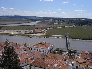
The Sado is a river in southern Portugal; it is one of the major rivers in the country. It flows in a northerly direction through 175 kilometres (109 mi) from its springs in the hills of Ourique before entering the Atlantic Ocean in an estuary in the city of Setúbal.

Albarquel Beach is a beach located in Setúbal, Portugal 30km southeast of Lisbon. The beach is on a bay overlooking the Tróia Peninsula and the city. The area is suitable for swimming, boating, windsurfing, and kitesurfing.

The Setúbal Peninsula is a peninsula in the Lisbon Region of Portugal. The peninsula is named after one of its larger cities, Setúbal, and is bordered by three bodies of water, the Atlantic Ocean in the west and southwest, the Tagus Estuary to the north and the Sado Estuary to the southeast.

Tróia is a peninsula located in Grândola Municipality, Portugal, next to the Sado River estuary. Tourism is the peninsula's main economic activity due to its long beaches facing the Atlantic. There is a ferry boat connection between the peninsula and the city of Setúbal. Tróia has important archaeological sites dating from the time when the peninsula was an island called Acalá, settled by the Romans.
Azeitão is a civil parish in the municipality of Setúbal, Portugal. It was formed in 2013 by the merger of the former parishes São Lourenço and São Simão. The population in 2011 was 18,877, in an area of 69.32 km2. It is composed of a cluster of small "aldeias" or small villages, some of those are: Vila Fresca de Azeitão, Vila Nogueira de Azeitão, Brejos de Azeitão, Aldeia de Irmãos, Aldeia Velha, Vendas de Azeitão. Two of the closest cities are Setúbal and Palmela. This region is very famous for the cheese and wine.

Arrábida Natural Park is a protected area in Portugal. Founded in 1976, the park occupies an area of 176.41 km2 (68.11 sq mi), covering the southernmost margin of the Setúbal Peninsula.

Palmela is a Portuguese wine region centered on the town of Palmela in the Setúbal Peninsula subregion. The wine region has the Denominação de Origem Controlada (DOC) status after having been elevated from its former Indicação de Proveniencia Regulamentada (IPR) status. At the same time, the former Arrábida IPR, centered on the Arrabida hills, was absorbed into Palmela DOC.

Castelo de Santiago do Cacém is a castle in the municipality of Santiago do Cacém, Portugal. It is classified as a national monument.

The Castle of Sesimbra, also known as Castle of the Moors, is a castle located in the town of Sesimbra, in the Setúbal District of Portugal. It was classified as a National Monument on 16 June 1910.

The Castle of Almada is a medieval castle located in the civil parish of Almada, Cova da Piedade, Pragal e Cacilhas, in the municipality of Almada, Portuguese Setúbal.

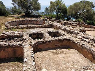
The Roman ruins of Creiro are situated in the Arrábida Natural Park above Creiro Beach in the Setúbal District of Portugal. They are ruins of a fish-salting factory and Roman baths, dating back to the days when the province of Lusitania formed part of the Roman Empire.

The Castro of Chibanes is located in the Arrábida Nature Park, on the Serra do Louro, in the municipality of Palmela in the Setúbal District of Portugal, about 25 km (16 mi) south of the capital of Lisbon, which can be seen from the site. The Castro, or hill fort, is located at the top of the hill, naturally defended by a scarp to the south. It covers about one hectare and was first occupied in about 2900 BCE, during the Chalcolithic or Copper Age. It is registered as a Zona Especial de Protecção and also classified as a Sitio de Interesse Público.

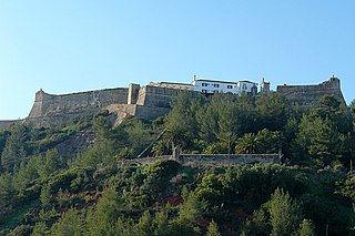
The Fort of São Filipe de Setúbal, also referred to as the São Filipe Castle or the São Filipe Fortress, is in the city of Setúbal in the Setúbal District, of Portugal. The fort was built on the orders of Philip II of Spain, who personally witnessed the laying of the cornerstone of the new fortification in 1582. It stands in a dominant position on the right bank of the mouth of the Sado River, overlooking the centre of Setúbal to its east and guarding access to the river. Named after the king during the Iberian Union, the fortress was designed by Giovan Giacomo Paleari Fratino and had the Italian military engineer Filipe Terzi, who worked for the Spanish Royal Court, as its chief engineer. It was completed in 1600 under the guidance of Leonardo Torreano due to the death of Terzi.

The Fort Santa Maria da Arrábida also referred to as Fort Nossa Senhora da Arrábida, Fort of Arrábida and Fort of Portinho da Arrábida, is located at the foot of the southern slope of the mountain range of the same name, in a dominant position to southwest of Portinho da Arrábida, on the northern bank of the Sado River, in the Municipality and District of Setúbal, in Portugal.


