Catequilla

Last updated
Catequilla

Catequilla.jpg

Aerial view of the Cerro de Catequilla, archaeological site at the summit
Alternate name Kati-Killa
Location Pomasqui Valley
Region Ecuador
Altitude 2,638 m (8,655 ft)
Type Archaeological site
Length 107m
Diameter 68m
Height 25cm
History
Material Stone
Founded 800
Cultures Quitu-Cara
Site notes
Archaeologists Oswaldo Tovar
Pre-Columbian lithic disk DiscoLitico.JPG
Pre-Columbian lithic disk

Monte Catequilla (also Kati-Killa) is an archaeological site in the Pomasqui Valley of Ecuador. Located in the Parish of San Antonio of Quito Canton in Pichincha Province, it has an elevation of 2,638 metres (8,655 ft) and is located on a mountaintop about 300 metres (980 ft) above valleys on either side. Attributed to the Pre-Columbian era Quitu-Cara culture, it was presumably used as an astronomical observatory even before the arrival of the Incas, and is the only prehispanic site in the Americas that is located precisely at the Earth's Equator. [1]

Archaeological site Place in which evidence of past activity is preserved

An archaeological site is a place in which evidence of past activity is preserved, and which has been, or may be, investigated using the discipline of archaeology and represents a part of the archaeological record. Sites may range from those with few or no remains visible above ground, to buildings and other structures still in use.

Pomasqui Valley

Pomasqui Valley is a valley on the northern outskirts of Quito, Ecuador. It is located on the equator, the so-called "Mitad del Mundo", at an altitude of around 2,600 metres (8,500 ft) above sea level. Hot and semi-arid, it is formed by a river tributary. The valley contains the Cerro de Catequilla, which contains the pre-Columbian astronomical observatory, Catequilla. The village of Pomasqui itself lies roughly 6 kilometres (3.7 mi) from the equator. The Monjas River flows nearby and the valley is an important centre for viniculture in Ecuador, with vineyards. The economy features vegetable and fruit production. To the northwest is the Pululahua Geobotanical Reserve.

Ecuador Republic in South America

Ecuador, officially the Republic of Ecuador, is a country in northwestern South America, bordered by Colombia on the north, Peru on the east and south, and the Pacific Ocean to the west. Ecuador also includes the Galápagos Islands in the Pacific, about 1,000 kilometres (620 mi) west of the mainland. The capital city is Quito and the largest city as well.

History

Catequilla is translated from Quechua to mean "follower of the moon". [2] Its construction, circa 800 AD, is attributed to the Quitu-Cara culture. [3] The site consists of a semicircular wall, 107 metres (351 ft) in length with a diameter of 68 metres (223 ft), although no clear architectural features accurately show the exact positions of its ends. It leans toward the east end south sides with at an azimuth of 113 degrees, and declines on the western end to the north side, with an azimuth of 293 degrees. The wall height varies between 25 centimetres (9.8 in) and 1.2 metres (3 ft 11 in), but based on the broken material beside it, the wall could have been more than 2 metres (6 ft 7 in) high. In the northwest of the site, there is a lithic disk (a circular stone-filled platform) 8 metres (26 ft) in diameter, consisting mainly of stone masonry. It has three lines of stones. Situated on a hill, [4] there was a water source at the site at one time. [5]

Quechuan languages language family spoken primarily in the Andes region of South America

Quechua, usually called Runasimi in Quechuan languages, is an indigenous language family spoken by the Quechua peoples, primarily living in the Peruvian Andes and highlands of South America. Derived from a common ancestral language, it is the most widely spoken language family of indigenous peoples of the Americas, with a total of probably some 8–10 million speakers. Approximately 25% of Peruvians speak a Quechuan language. It is perhaps most widely known for being the main language of a family of the Inca Empire. The Spanish colonisers initially encouraged its use, but from the middle of their reign they suppressed it. However, Quechua ultimately survived, and variants are still widely spoken today.

Azimuth the angle between a reference plane and a point

An azimuth is an angular measurement in a spherical coordinate system. The vector from an observer (origin) to a point of interest is projected perpendicularly onto a reference plane; the angle between the projected vector and a reference vector on the reference plane is called the azimuth.

A stone tool is, in the most general sense, any tool made either partially or entirely out of stone. Although stone tool-dependent societies and cultures still exist today, most stone tools are associated with prehistoric cultures that have become extinct. Archaeologists often study such prehistoric societies, and refer to the study of stone tools as lithic analysis. Ethnoarchaeology has been a valuable research field in order to further the understanding and cultural implications of stone tool use and manufacture.

Along with the stone-filled circles of Jarata and Pacpo to the south, it forms a straight line along which the shade from the mountains falls during the June solstice. While many of the indigenous people today believe that the purpose of these circles was to provide a solid flat surface for the threshing of wheat and other cereals, several astronomic and geodetic alignments have been detected, questioning the validity of this theory. After several archaeological excavations by Oswaldo Tovar, many ceramics were unearthed from Incan and colonial times. Though the site is virtually abandoned, nearby mining operations in the area could jeopardize its integrity. Even so, the government has taken no action. [6] As it is located on the equator, it is said to be in the "Middle of the World". As of 2011, it is said to be "the only important pre-Inca site in Ecuador to have been commercially exploited." [7]

A solstice is an event occurring when the Sun appears to reach its most northerly or southerly excursion relative to the celestial equator on the celestial sphere. Two solstices occur annually, around June 21 and December 21. The seasons of the year are determined by reference to both the solstices and the equinoxes.

Indigenous peoples in Ecuador

Indigenous peoples in Ecuador, also Native Ecuadorians or Native Americans, are the groups of people who were present in what became Ecuador before the Spanish colonization of the Americas. The term also includes their descendants from the time of the Spanish conquest to the present. Their history, which encompasses the last 11,000 years, reaches into the present; 25 percent of Ecuador's population is of indigenous heritage, while another 70 percent is of mixed indigenous and European heritage.

Geodetic datum reference frame used in geodesy, surveying, chartography and navigation

A geodetic datum or geodetic system is a coordinate system, and a set of reference points, used to locate places on the Earth. An approximate definition of sea level is the datum WGS 84, an ellipsoid, whereas a more accurate definition is Earth Gravitational Model 2008 (EGM2008), using at least 2,159 spherical harmonics. Other datums are defined for other areas or at other times; ED50 was defined in 1950 over Europe and differs from WGS 84 by a few hundred meters depending on where in Europe you look. Mars has no oceans and so no sea level, but at least two martian datums have been used to locate places there.

The Inca pucara (stone fortress) of Rumicucho is located about 1,550 metres (5,090 ft) north of Catequilla.

Inca Empire empire in pre-Columbian America

The Inca Empire, also known as the Incan Empire and the Inka Empire, was the largest empire in pre-Columbian America. Its political and administrative structure is considered by most scholars to have been the most developed in the Americas before Columbus' arrival. The administrative, political and military center of the empire was located in the city of Cusco. The Inca civilization arose from the Peruvian highlands sometime in the early 13th century. Its last stronghold was conquered by the Spanish in 1572.

Related Research Articles

The History of Ecuador extends over an 8,000-year period. During this time a variety of cultures and territories influenced what has become the Republic of Ecuador. The history can be divided into five eras: Pre-Columbian, the Conquest, the Colonial Period, the War of Independence, Gran Colombia, and Simón Bolívar the final separation of his vision into what is known today as the Republic of Ecuador.

Quito Capital city in Pichincha, Ecuador

Quito is the capital and the largest city of Ecuador, and at an elevation of 2,850 metres (9,350 ft) above sea level, it is the second-highest official capital city in the world, after La Paz, and the one which is closest to the equator. It is located in the Guayllabamba river basin, on the eastern slopes of Pichincha, an active stratovolcano in the Andes Mountains. With a population of 2,671,191 according to statistical projections (2019), Quito is the most populous city in Ecuador. It is also the capital of the Pichincha province and the seat of the Metropolitan District of Quito. The canton recorded a population of 2,239,191 residents in the 2010 national census. In 2008, the city was designated as the headquarters of the Union of South American Nations.

Inca road system Transportation system of the Inca empire

The Inca road system was the most extensive and advanced transportation system in pre-Columbian South America. It was about 39,900 kilometres (24,800 mi) long. The construction of the roads required a large expenditure of time and effort. The network was based on two north-south roads with numerous branches. The best known portion of the road system is the Inca Trail to Machu Picchu. Part of the road network was built by cultures that precede the Inca Empire, notably the Wari culture. During the Spanish colonial era, parts of the road system were given the status of Camino Real. In 2014 the road system became a UNESCO World Heritage Site.

Atahualpa Ruler of the Inca Empire

Atahualpa, also Atahuallpa, Atabalipa or Atawallpa (Quechua) was the last Inca Emperor. After defeating his brother, Atahualpa became very briefly the last Sapa Inca of the Inca Empire (Tawantinsuyu) before the Spanish conquest.

Ciudad Mitad del Mundo Città Metà del Mondo

The Ciudad Mitad del Mundo is a tract of land owned by the prefecture of the province of Pichincha, Ecuador. It is located at San Antonio parish of the canton of Quito, 26 km north of the center of Quito. The grounds contain the Monument to the Equator, which highlights the exact location of the Equator and commemorates the eighteenth century Franco-Spanish Geodesic Mission which fixed its approximate location; they also contain the Museo Etnográfico Mitad del Mundo, Ethnographic Museum Middle of the Earth, a museum about the indigenous people ethnography of Ecuador.

Pambamarca mountain in Ecuador

Pambamarca is an eroded stratovolcano in the Central Cordillera of the northern Ecuadorian Andes in Pichincha Province. it is 25 miles (40 km) northeast of Quito. The summit is at an elevation of 4,062 metres (13,327 ft).

The French Geodesic Mission was an 18th-century expedition to what is now Ecuador carried out for the purpose of measuring the roundness of the Earth and measuring the length of a degree of latitude at the Equator. The mission was one of the first geodesic missions carried out under modern scientific principles, and the first major international scientific expedition.

The Cara culture flourished in coastal Ecuador, in what is now Manabí Province, in the first millennium CE.

Pre-Columbian Ecuador Ecaudor before Spanish colonization

Pre-Columbian Ecuador included numerous indigenous cultures, who thrived for thousands of years before the ascent of the Incan Empire. Las Vegas culture of coastal Ecuador is one of the oldest cultures in the Americas. The Valdivia culture in the Pacific coast region is a well-known early Ecuadorian culture. Ancient Valdivian artifacts from as early as 3500 BC have been found along the coast north of the Guayas Province in the modern city of Santa Elena.

Equator Intersection of a spheres surface with the plane perpendicular to the spheres axis of rotation and midway between the poles

An equator of a rotating spheroid is its zeroth circle of latitude (parallel). It is the imaginary line on the spheroid's surface, equidistant from its poles, dividing it into northern and southern hemispheres. In other words, it is the intersection of the spheroid's surface with the plane perpendicular to its axis of rotation and midway between its geographical poles.

La Alameda Park, Quito

La Alameda Park is a park in Quito.

Otavalo people

The Otavalos are an indigenous people native to the Andean mountains of Imbabura Province in northern Ecuador. The Otavalos also inhabit the city of Otavalo in that province. Commerce and handcrafts are among the principal economic activities of the Otavalos, who enjoy a higher standard of living than most indigenous groups in Ecuador and many mestizos of their area.

Quitsato Sundial

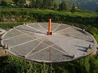
The Quitsato Sundial is a cultural-tourist place located at La Mitad Del Mundo, near to Cayambe, 47 km north of Quito. It was built in 2006 and inaugurated in 2007 as an independent, non-profit project in a 24,756 ft² area. Its main goal is to share crucial aspects of the astronomical knowledge of the prehispanic cultures of the region. The expositions are carried out by community members as a self-sustaining project. According to Google Maps, the central pillar is 4 meters south of the true equator.

Cochasquí

Cochasquí is the "most extensive and most important complex" of Pre-Columbian and pre-Inca Empire ruins in northern Ecuador. The site lies some 30 kilometres (19 mi) in straight-line distance northeast of Quito in Pedro Moncayo Canton in Pichincha Province at 3,040 metres (9,970 ft) meters above sea level.

Inca-Caranqui Archaeological site in Ecuador

The Inca-Caranqui archaeological site is located in the village of Caranqui on the southern outskirts of the city of Ibarra, Ecuador. The ruin is located in a fertile valley at an elevation of 2,299 metres (7,543 ft). The region around Caranqui, extending into the present day country of Colombia, was the northernmost outpost of the Inca Empire and the last to be added to the empire before the Spanish conquest of 1533. The archaeological region is also called the Pais Caranqui.

Pambamarca Fortress Complex

The Pambamarca Fortress Complex consists of the ruins of a large number of pukaras and other constructions of the Inca Empire. The fortresses were constructed in the late 15th century by the Incas to overcome the opposition of the people of the Cayambe chiefdom to the expansion of the Incas in the Andes highlands of present-day northern Ecuador. The Pambamarca fortreses are located in Cayambe Canton in Pichincha Province about 32 kilometres (20 mi) in a straight-line distance northeast of the city of Quito.

Rumicucho

Rumicucho or Pucara de Rumicucho is an archaeological site of the Inca Empire in the parroquia of San Antonio de Pichincha, in Quito Canton, Pichincha Province. Ecuador. Rumicucho is a pucara located 23 kilometres (14 mi) in a straight-line distance north of the city of Quito at an elevation of 2,401 metres (7,877 ft). Rumicucho in the Quechua language means "stone corner", perhaps referring to its strategic location between the territory of the Yumbo people to the east and the chiefdoms of the Pais Caranqui to the north.

Manuela de la Santa Cruz y Espejo

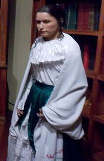
María Manuela Dominga de Espejo y Aldaz, known as Manuela of the Holy Cross and Mirror was an Ecuadorian journalist, nurse, feminist, and revolutionary. She was the sister of Eugenio Espejo, with whom she discussed and shared Enlightenment and revolutionary, pro-revolutionary thought and ideas.

References

  1. Cobo, Cristóbal (2004). "El sitio arqueológico Sobre el Monte Catequilla en la Latitud Cero". Memorias del Simposio ARQ-13 del 51 Congreso Internacional de Americanistas (in Spanish). Chile: Pereira editores.
  2. Kelley, David H.; Milone, Eugene F.; Aveni, A.F. (18 February 2011). Exploring Ancient Skies: A Survey of Ancient and Cultural Astronomy. Springer. p. 467. ISBN   978-1-4419-7623-9 . Retrieved 16 July 2012.
  3. Adès, Harry; Graham, Melissa (4 January 2010). The Rough Guide to Ecuador. Penguin. pp. 245–. ISBN   978-1-84836-191-1 . Retrieved 20 July 2012.
  4. Zambrano, Ricardo P. (2006). Quito: Patrimonio de la Humanidad (in Spanish). Libresa. pp. 49–. ISBN   978-9978-49-052-5 . Retrieved 20 July 2012.
  5. Costales, Piedad Peñaherrera de; Samaniego, Alfredo Costales; Peñaherrera, Jaime Costales (1996). Mitos Quitu-Cara (in Spanish). Editorial Abya Yala. pp. 40–. ISBN   978-9978-04-423-0 . Retrieved 20 July 2012.
  6. Folklore (in Spanish). Lima: s.n. 1942. p. 130. Retrieved 20 July 2012.
  7. Jacobs, Michael (5 May 2011). Andes. Granta Publications. p. 153. ISBN   978-1-84708-386-9 . Retrieved 16 July 2012.

Coordinates: 0°0′0″N78°25′43.3″W / 0.00000°N 78.428694°W / 0.00000; -78.428694

Geographic coordinate system Coordinate system

A geographic coordinate system is a coordinate system that enables every location on Earth to be specified by a set of numbers, letters or symbols. The coordinates are often chosen such that one of the numbers represents a vertical position and two or three of the numbers represent a horizontal position; alternatively, a geographic position may be expressed in a combined three-dimensional Cartesian vector. A common choice of coordinates is latitude, longitude and elevation. To specify a location on a plane requires a map projection.