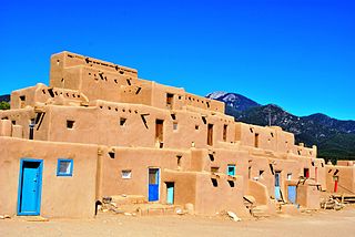
Taos Pueblo is an ancient pueblo belonging to a Taos-speaking (Tiwa) Native American tribe of Puebloan people. It lies about 1 mile (1.6 km) north of the modern city of Taos, New Mexico. The pueblos are considered to be one of the oldest continuously inhabited communities in the United States. This has been designated a UNESCO World Heritage Site.

Taos is a town in Taos County in the north-central region of New Mexico in the Sangre de Cristo Mountains, incorporated in 1934. As of the 2010 census, its population was 5,716. Other nearby communities include Ranchos de Taos, Cañon, Taos Canyon, Ranchitos, El Prado, and Arroyo Seco. The town is close to Taos Pueblo, the Native American village and tribe from which it takes its name.

Rio Arriba County is a county in the U.S. state of New Mexico. As of the 2010 census, the population was 40,246. Its county seat is Tierra Amarilla. Its northern border is the Colorado state line.

Mora County is a county in the US state of New Mexico. As of the 2010 census, the population was 4,881. Its county seat is the census-designated place (CDP) Mora. The county has another CDP, Watrous, a village, Wagon Mound, New Mexico, and 12 smaller unincorporated settlements. Mora became a formal county in the US, in what was then the New Mexico Territory, on February 1, 1860. Ecclesiastically, the county is within the Roman Catholic Archdiocese of Santa Fe. County population peaked at about 14,000 around 1920, declining to about 4,000 to 5,000 since the 1970s; the 2016 estimate was 4,500.

In the Southwestern United States, the term Pueblo refers to communities of Native Americans, both in the present and in ancient times. The first Spanish explorers of the Southwest used this term to describe the communities housed in apartment structures built of stone, adobe mud, and other local material. These structures were usually multi-storied buildings surrounding an open plaza. The rooms were accessible only through ladders lowered by the inhabitants, thus protecting them from break-ins and unwanted guests. Larger pueblos were occupied by hundreds to thousands of Pueblo people. Various federally recognized tribes have traditionally resided in pueblos of such design.

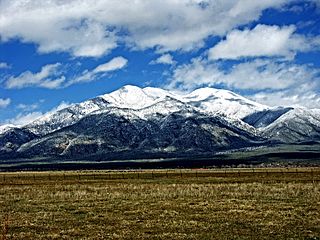
Wheeler Peak is the highest natural point in the U.S. state of New Mexico. It is located northeast of Taos and south of Red River in the northern part of the state, and just 2 miles (3.2 km) southeast of the ski slopes of Taos Ski Valley. It lies in the Sangre de Cristo Mountains, the southernmost subrange of the Rocky Mountains. The peak's elevation is 13,167 feet (4,013 m).
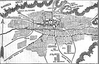
The Capture of Santa Fe, also known as the Battle of Santa Fe or the Battle of Cañoncito, took place near Santa Fe, New Mexico, the capital of the Mexican Province of New Mexico, during the Mexican–American War on 8 August through 14 August 1846. No shots were fired during the capturing of Santa Fe.

Carson National Forest is a national forest in northern New Mexico, United States. It encompasses 6,070 square kilometers and is administered by the United States Forest Service. The Forest Service's "mixed use" policy allows for its use for recreation, grazing, and resource extraction.

Tohajiilee, Cañoncito Band of Navajos is a non-contiguous section of the Navajo Nation lying in parts of western Bernalillo, eastern Cibola, and southwestern Sandoval counties in the U.S. state of New Mexico, west of the city of Albuquerque. It is a Navajo phrase roughly translated in English as "Dipping Water".

Joseph Horace Eaton was an American artist and a career officer in the United States Army. He served as a major during the American Civil War. In recognition of his service, in 1866 he was nominated and in 1867 he was confirmed for appointment to the grade of brevet brigadier general in the regular army to rank from March 13, 1865.

Cañoncito is an unincorporated community in Bernalillo County, New Mexico, United States. Cañoncito is located along New Mexico State Road 14 13.5 miles (21.7 km) east of central Albuquerque.
Cañoncito or Canoncito may refer to the following places in the U.S. state of New Mexico:
Cañoncito is an unincorporated community in Rio Arriba County, New Mexico, United States. Cañoncito is located on Embudo Creek 3.4 miles (5.5 km) east-southeast of Dixon.
Cañoncito is an unincorporated community in Santa Fe County, New Mexico, United States. Cañoncito is located on Interstate 25, 11.5 miles (18.5 km) southeast of Santa Fe. Nuestra Señora de Luz Church and Cemetery, which is listed on the National Register of Historic Places, is located in Cañoncito.
Canoncito is an unincorporated community in Mora County, New Mexico, United States. Canoncito is located along New Mexico State Road 518 25 miles (40 km) north of Las Vegas.
Canoncito is an unincorporated community in San Miguel County, New Mexico, United States. Canoncito is 15.2 miles (24.5 km) north-northwest of Las Vegas.
The Dixon Studio Tour is the oldest continuously-running studio tour in northern New Mexico. It occurs annually in the fall in the Embudo Valley, and encompassing Dixon, Rinconada, Embudo, Apodaca and Cañoncito, and Cuestacitas.
Operation Santa Fe was a security operation conducted during the Vietnam War by the U.S. 1st Brigade, 9th Infantry Division, the 1st Australian Task Force and the Army of the Republic of Vietnam (ARVN) 18th Division against the May Tao Secret Zone, South Vietnam from 3 November 1967 to 5 January 1968.