Cedar Bluff State Park

Last updated
Cedar Bluff State Park
Kansas State Park
Cedarblufflimestone.jpg
Limestone on the edge of Cedar Bluff
CountryFlag of the United States.svg  United States
StateFlag of Kansas.svg  Kansas
County Trego County, Kansas
Elevation2,185 ft (666 m) [1]
Coordinates 38°48′41″N99°43′57″W / 38.81139°N 99.73250°W / 38.81139; -99.73250 Coordinates: 38°48′41″N99°43′57″W / 38.81139°N 99.73250°W / 38.81139; -99.73250   [1]
Area850 acres (344.0 ha)
Established1962
Management Kansas Department of Wildlife, Parks and Tourism
USA Kansas location map.svg
Red pog.svg
Location in Kansas
Website: Cedar Bluff State Park

Cedar Bluff State Park is a public recreation area located 21 miles (34 km) southeast of WaKeeney and 23 miles (37 km) southwest of Ellis in Trego County, Kansas, United States.

WaKeeney, Kansas City and County seat in Kansas, United States

WaKeeney is a city in and the county seat of Trego County, Kansas, United States. As of the 2010 census, the city population was 1,862.

Ellis, Kansas City in Kansas, United States

Ellis is a city in Ellis County, Kansas, United States. As of the 2010 census, the city population was 2,062.

Trego County, Kansas County in the United States

Trego County is a county located in the U.S. state of Kansas. As of the 2010 census, the county population was 3,001. Its county seat and largest city is WaKeeney.

Contents

The state park is divided into two areas, comprising 850 acres (340 ha), straddling the 6,800-acre (2,800 ha) Cedar Bluff Reservoir. The Bluffton Area—300 acres (120 ha) on the north shore—is the most developed and receives extensive use. The Page Creek Area—500 acres (200 ha) on the south shore—offers primitive camping as well as 36 utility sites. [2] West of the Page Creek Area are the juniper-lined, 100-foot-tall (30 m) limestone bluffs from which the reservoir's name was derived (junipers were often misidentified as "cedars" by early settlers).

State park protected area managed at the federated state level

State parks are parks or other protected areas managed at the sub-national level within those nations which use "state" as a political subdivision. State parks are typically established by a state to preserve a location on account of its natural beauty, historic interest, or recreational potential. There are state parks under the administration of the government of each U.S. state, some of the Mexican states, and in Brazil. The term is also used in the Australian state of Victoria. The equivalent term used in Canada, Argentina, South Africa and Belgium, is provincial park. Similar systems of local government maintained parks exist in other countries, but the terminology varies.

Cedar Bluff Reservoir

Cedar Bluff Reservoir is a reservoir in Trego County, Kansas, United States. Built and managed by the U.S. Bureau of Reclamation for irrigation and area water supply, it is also used for flood control and recreation. Cedar Bluff State Park is located on its shore.

Juniper genus of plants

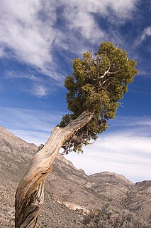
Junipers are coniferous plants in the genus Juniperus of the cypress family Cupressaceae. Depending on taxonomic viewpoint, between 50 and 67 species of junipers are widely distributed throughout the Northern Hemisphere, from the Arctic, south to tropical Africa, from Ziarat, Pakistan, east to eastern Tibet in the Old World, and in the mountains of Central America. The highest-known juniper forest occurs at an altitude of 16,000 ft (4,900 m) in southeastern Tibet and the northern Himalayas, creating one of the highest tree-lines on earth.

Threshing Machine Canyon, the site of an 1850s Native American attack on a wagon train bearing a threshing machine, is accessed by a road west of the park. In the historic canyon one can find carvings dating back to the mid-19th century. [3]

Threshing machine agricultural machine

A threshing machine or thresher is a piece of farm equipment that threshes grain, that is, it removes the seeds from the stalks and husks. It does so by beating the plant to make the seeds fall out.

Canyon Deep ravine between cliffs

A canyon or gorge is a deep cleft between escarpments or cliffs resulting from weathering and the erosive activity of a river over geologic timescales. Rivers have a natural tendency to cut through underlying surfaces, eventually wearing away rock layers as sediments are removed downstream. A river bed will gradually reach a baseline elevation, which is the same elevation as the body of water into which the river drains. The processes of weathering and erosion will form canyons when the river's headwaters and estuary are at significantly different elevations, particularly through regions where softer rock layers are intermingled with harder layers more resistant to weathering.

See also

Related Research Articles

Cossatot River State Park-Natural Area

Cossatot River State Park-Natural Area is a 5,299.65-acre (2,144.69 ha) Arkansas state park in Howard County and Polk County, Arkansas in the United States. The park follows a rough, undeveloped 12.5 miles (20.1 km) of the Cossatot River. The river itself is included in Arkansas's Natural and Scenic Rivers System and the National Park Service's list of National Wild and Scenic Rivers, making it a whitewater rafting destination. The rough nature of the river, including Class III, IV, and dangerous Class V rapids, make the park-natural area a popular destination for skilled canoeists, kayakers, and playboaters. The park became a part of the system in 1988 after the Arkansas Department of Parks and Tourism and Arkansas Natural Heritage Commission agreed to cooperative management after acquiring the property from the Weyerhaeuser Corporation.

Cheney State Park

Cheney State Park is a state park of Kansas in the United States. Completed in 1964, the park is located in Kingman and Reno counties in Kansas, 5 miles north of Cheney and 20 miles west of Wichita.

Elk City State Park state park in Kansas, USA

Elk City State Park is a state park in Montgomery County, Kansas, United States, located west of Independence.

Kanopolis State Park

Kanopolis State Park contains a reservoir, desert plants such as yucca, a prairie dog town, and scenic sandstone canyons. It is located in the Smoky Hills region of the U.S. state of Kansas. The park is located southwest of the city of Salina, just south of I-70.

Wilson Lake (Kansas) reservoir in Kansas, United States of America

Wilson Lake is a reservoir in the U.S. state of Kansas, on the border of Russell County and Lincoln County. Built and managed by the U.S. Army Corps of Engineers for flood control, it is also used for wildlife management and recreation. Several parks are located along its shoreline, including Wilson State Park.

Perry Lake (Kansas) lake in Kansas, United States

Perry Lake is a US Army Corps of Engineers operated reservoir in northeast Kansas. Its primary purposes are flood control, water reserve for nearby areas and regional recreation. The lake is approximately 11,150 acres (45 km²) in size, with over 160 miles of shoreline. Perry Lake's full multi-purpose pool elevation is 891.5 feet above sea level. Perry Lake is located about 40 miles west of Kansas City, just northwest of Lawrence, Kansas. Its close proximity to Kansas City, Lawrence, and the state capitol, Topeka, make it a very popular destination, with the nickname "Paradise on the Plains".

Wilson State Park (Kansas)

Wilson State Park is a public recreation area found on the south shore of 9,000-acre (3,600 ha) Wilson Lake reservoir approximately 10 miles (16 km) north of the city of Wilson in Russell County, Kansas, United States. Located at the reservoir's eastern end, the state park covers 945 acres (382 ha) divided into two areas by the reservoir's southeastern arm: the Hell Creek area on the west side and the Otoe area on the east side. The Hell Creek area hosts a marina. Both areas include hiking trails, swimming beaches, boat ramps, and camping facilities.

El Dorado Lake reservoir in Kansas, United States of America

El Dorado Lake is a reservoir on the Walnut River 0.5 miles (0.80 km) northeast of El Dorado in the Flint Hills region of Kansas. Built and managed by the U.S. Army Corps of Engineers, it is used for flood control, recreation, and water supply. El Dorado State Park is located on its shore.

Crooked River (Oregon) tributary of the Deschutes River in the U.S. state of Oregon

The Crooked River is a tributary, 125 miles (201 km) long, of the Deschutes River in the U.S. state of Oregon. The river begins at the confluence of the South Fork Crooked River and Beaver Creek. Of the two tributaries, the South Fork Crooked River is the larger and is sometimes considered part of the Crooked River proper. A variant name of the South Fork Crooked River is simply "Crooked River". The Deschutes River flows north into the Columbia River.

John Redmond Reservoir

John Redmond Reservoir is a reservoir on the Neosho River in eastern Kansas. Built and managed by the U.S. Army Corps of Engineers, it is used for flood control, recreation, water supply, and wildlife management. It borders the Flint Hills National Wildlife Refuge to the northwest.

Sylvan Lake State Park

Sylvan Lake State Park is a Colorado state park located in Eagle County, 10 miles (16 km) south of Eagle, Colorado. The 1,548-acre (626 ha) park established in 1987 and surrounded by the White River National Forest includes a 42-acre (17 ha) lake and 1.5 miles (2.4 km) of trails. Facilities include a visitors center, boat ramp, campsites, cabins, yurts and picnic sites. Plant communities include aspen groves, lodgepole pine and Douglas fir forests on moist slopes. Ponderosa pine and juniper are found on drier slopes. Wetland and riparian areas exist near the reservoir and creek. Common wildlife includes black bear, elk, mule deer, pine marten and beaver.

Keith Sebelius Lake

Keith Sebelius Lake, formerly known as Norton Reservoir, is a man-made reservoir on Prairie Dog Creek in northwest Kansas. Built and managed by the U.S. Bureau of Reclamation, it is used for flood control, irrigation, recreation, and local water supply. Prairie Dog State Park is located on its shore.

Waconda Lake

Waconda Lake, also known as Glen Elder Reservoir, is a reservoir in Mitchell County and Osborne County, Kansas, United States. Built and managed by the U.S. Bureau of Reclamation for flood control and irrigation, it is also used for recreation. Glen Elder State Park is located on its north shore.

Kaw River State Park

Kaw River State Park is a state park in Topeka, Kansas, USA. Kaw River, the only urban type state park in Kansas, is relatively small at 76 acres (31 ha). The property was donated to the state in 2005 and officially opened to the public on September 4, 2010, making it the most recent unit of the Kansas State Park service.

Lovewell Reservoir

Lovewell Reservoir is a reservoir in Jewell County, Kansas, United States. Built and managed by the U.S. Bureau of Reclamation, it is used for flood control, irrigation, and recreation. Lovewell State Park is located on its north shore.

Kanopolis Lake

Kanopolis Lake is a reservoir in Ellsworth County in the Smoky Hills of central Kansas, about 31 miles southwest of Salina and a few miles southeast of the town of Kanopolis. The lake is formed by Kanopolis Dam. Completed in 1948 as a flood control and water conservation project of the United States Army Corps of Engineers, the dam impounds the Smoky Hill River.

Cheney Reservoir

Cheney Reservoir is a reservoir on the North Fork Ninnescah River in Reno, Kingman, and Sedgwick counties of Kansas in the United States. Built and managed by the U.S. Bureau of Reclamation for local water supply, it is also used for flood control and recreation. Cheney State Park is located on its shore.

Council Grove Lake

Council Grove Lake is a reservoir on the Neosho River in east-central Kansas. Built and managed by the U.S. Army Corps of Engineers, it is used for flood control, recreation, and water supply.

References

  1. 1 2 "Cedar Bluff State Park Office". Geographic Names Information System . United States Geological Survey.
  2. "Cedar Bluff State Park". Kansas Department of Wildlife, Parks and Tourism. Retrieved November 22, 2012.
  3. "Cedar Bluff Reservoir, State Park, and Wildlife Area". Kansas Office of Tourism & Travel. Retrieved May 24, 2017.