Mushroom Rock | |
---|---|
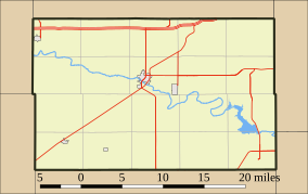
Location of Mushroom Rock State Park in Ellsworth County, KansasMap showing location of park | |
Location | Carneiro and Ellsworth, Kansas, Ellsworth County, Kansas, Smoky Hills, Kansas, United States |
Coordinates | 38°43′33″N98°01′50″W / 38.72583°N 98.03056°W |
Area | 5 acres |
Elevation | 488 m (1,601 ft) |
Established | 25 April 1965 |
Operator | Kansas Department of Wildlife, Parks and Tourism |
Website | KDWP Website |
Mushroom Rock State Park is noted for its mushroom rock formations. It is located in the Smoky Hills region of north-central Kansas in Ellsworth County, Kansas, United States.
These rocks are the remains of beach sands and sediments of the Cretaceous Period, the interval of geologic time from about 144 to 66 million years ago. Sandstone and sedimentary rock is held together by natural cement. The concretions that make up Mushroom Rocks are cemented calcium carbonate. The largest rock measures 27 feet in diameter. [1] There are two mushrooms and a giant shoe rock, as well as numerous other rock formations in the 5-acre (2.0 ha) park.
Mushroom Rock is Kansas's smallest state park; [2] as well as being "one of the 8 wonders of Kansas Geography." [2] Mushroom Rock State Park is managed by Kanopolis State Park, [1] under regulation of Kansas Department of Wildlife, Parks and Tourism. The rock used to serve as meeting places for pioneers and Native Americans. [1]
Other rock formations in Kansas:
Ellsworth County is a county located in the U.S. state of Kansas. Its county seat and most populous city is Ellsworth. As of the 2020 census, the county population was 6,376. The county was named after Fort Ellsworth.
Ellsworth is a city in and the county seat of Ellsworth County, Kansas, United States. As of the 2020 census, the population of the city was 3,066. Known as a cow town in the 1870s, when the Kansas Pacific Railroad operated a stockyard here for shipping cattle to eastern markets, in the 21st century, it serves as the trading center of the rural county.
Kanopolis is a city in Ellsworth County, Kansas, United States. As of the 2020 census, the population of the city was 443. It was built on the site of Fort Harker, a United States Army post that housed infantry and cavalry troops involved in the Indian Wars from 1867 to 1872.
The Smoky Hill River is a 575-mile (925 km) river in the central Great Plains of North America, running through Colorado and Kansas.
A mushroom rock, also called rock pedestal, or a pedestal rock, is a naturally occurring rock whose shape, as its name implies, resembles a mushroom. The rocks are deformed in a number of different ways: by erosion and weathering, glacial action, or from a sudden disturbance. Mushroom rocks are related to, but different from, yardang.
The Kansas Geological Survey (KGS), a research and service division of the University of Kansas, is charged by statute with studying and providing information on the geologic resources of Kansas. The KGS has no regulatory authority and does not take positions on natural resource issues.
Rock City is a park located on hillsides overlooking the Solomon River in Ottawa County, Kansas. It is 3.6 miles south of Minneapolis, Kansas and just over 0.5 mile west of Kansas highway K-106 and the Minneapolis City County Airport on Ivy Road. In a patch of prairie about 500 meters long and 40 meters wide, Rock City contains three clusters of large spherical boulders. These three clusters contain a total of 200 spherical boulders. It has been designated as a National Natural Landmark.
Castle Rock is a 70 ft (21 m) tall chalk pillar landmark in Gove County, Kansas, United States. The formation and the nearby badlands are located in the Smoky Hills region of Kansas, which is approximately 11 mi (18 km) south of I-70 near Quinter, Kansas.
The Smoky Hills are an upland region of hills in the central Great Plains of North America. They are located in the Midwestern United States, encompassing north-central Kansas and a small portion of south-central Nebraska.
Kanopolis State Park contains a reservoir, desert plants such as yucca, a prairie dog town, and scenic sandstone canyons. It is located in the Smoky Hills region of the U.S. state of Kansas. The park is located southwest of the city of Salina, just south of I-70.
Carneiro is an unincorporated community in Ellsworth County, Kansas, United States. It is located approximately 10 miles (16 km) east of Ellsworth, north of Mushroom Rock State Park and Kanopolis Lake.
The Black Hills is an isolated mountain range rising from the Great Plains of North America in western South Dakota and extending into Wyoming, United States. Black Elk Peak, which rises to 7,244 feet (2,208 m), is the range's highest summit. The Black Hills encompass the Black Hills National Forest. The name of the hills in Lakota is Pahá Sápa. The Black Hills are considered a holy site. The hills are so called because of their dark appearance from a distance, as they are covered in evergreen trees.
This is a list of the National Register of Historic Places listings in Ellsworth County, Kansas.
The Kansas Department of Wildlife and Parks (KDWP) is a state cabinet-level agency led by a Secretary of Wildlife and Parks appointed by the Governor of Kansas. The Office of the Secretary is located in Topeka, the state capital of Kansas. A seven-member, bipartisan commission, also appointed by the Governor, advises the Secretary and approves regulations governing outdoor recreation and fish and wildlife resources in Kansas. KDWP employs approximately 420 full-time employees in five divisions: Executive Services, Administrative Services, Fisheries and Wildlife, Law Enforcement, and Parks. At full staffing, KDWP Law Enforcement Division (Kansas Game Wardens) is staffed by 83 positions.
Kanopolis Lake is a reservoir in Ellsworth County in the Smoky Hills of central Kansas, about 31 miles southwest of Salina and a few miles southeast of the town of Kanopolis. The lake is formed by Kanopolis Dam. Completed in 1948 as a flood control and water conservation project of the United States Army Corps of Engineers, the dam impounds the Smoky Hill River.
K-141 is a 13.47-mile-long (21.68 km) north–south state highway in Ellsworth County in central Kansas. The highway connects K-4 west of Marquette and K-140 northeast of Carneiro with Kanopolis Lake. The entire length of K-141 is a part of the Prairie Trail Scenic Byway, which was designated to highlight the history, culture, and nature of the area. The highway is a two-lane road its entire length.
Langley is an unincorporated community in Ellsworth County, Kansas, United States. It is located approximately 4 miles (6.4 km) south of Kanopolis Lake.
Venango is an unincorporated community in Ellsworth County, Kansas, United States. It is located on the east bank of the Kanopolis Lake.
Yankee Run is an unincorporated community in Ellsworth County, Kansas, United States. It is located on the west bank of the Kanopolis Lake.
Terra Cotta is a ghost town in Ellsworth County, Kansas, United States.