Center Ridge, Arkansas

Last updated

Center Ridge, Arkansas
Conway County Arkansas Incorporated and Unincorporated areas Center Ridge Highlighted 0512790.svg
Location of Center Ridge in Conway County, Arkansas.
USA Arkansas location map.svg
Red pog.svg
Center Ridge
Coordinates: 35°22′26″N92°33′47″W / 35.37389°N 92.56306°W / 35.37389; -92.56306
Country United States
State Arkansas
County Conway
Area
[1]
  Total9.52 sq mi (24.67 km2)
  Land9.47 sq mi (24.53 km2)
  Water0.05 sq mi (0.14 km2)
Elevation
[2]
728 ft (222 m)
Population
 (2020)
  Total290
  Density30.62/sq mi (11.82/km2)
Time zone UTC-6 (Central (CST))
  Summer (DST) UTC-5 (CDT)
Area code 501
GNIS feature ID2612124 [2]

Center Ridge is an unincorporated census-designated place in Conway County, Arkansas, United States. Per the 2020 census, the population was 2,235. [3]

Contents

Demographics

Historical population
CensusPop.Note
2010 388
2020 290−25.3%
U.S. Decennial Census [4]
2010 [5] 2020 [6]

2020 census

Center Ridge CDP, Arkansas – Racial and ethnic composition
Note: the US Census treats Hispanic/Latino as an ethnic category. This table excludes Latinos from the racial categories and assigns them to a separate category. Hispanics/Latinos may be of any race.
Race / Ethnicity (NH = Non-Hispanic)Pop 2010 [5] Pop 2020 [6] % 2010% 2020
White alone (NH)34325988.40%89.31%
Black or African American alone (NH)2065.15%2.07%
Native American or Alaska Native alone (NH)1303.35%0.00%
Asian alone (NH)200.52%0.00%
Pacific Islander alone (NH)000.00%0.00%
Some Other Race alone (NH)000.00%0.00%
Mixed Race or Multi-Racial (NH)3160.77%5.52%
Hispanic or Latino (any race)791.80%3.10%
Total388290100.00%100.00%

Education

Center Ridge is the headquarters of the Nemo Vista School District and home to Nemo Vista High School. The school's mascot is the Redhawks and red and white serve as the school colors.

Notable people

Catholic Point

To the southeast of Center Ridge is a small Italian settlement named Catholic Point that was founded in the late nineteenth century. It maintains its cultural identity and attracts over 2500 people yearly to its annual church picnic. [7]

Related Research Articles

<span class="mw-page-title-main">Prairie Creek, Arkansas</span> CDP in Arkansas, United States

Prairie Creek is a census-designated place (CDP) in Benton County, Arkansas, United States. Per the 2020 census, the population was 2,217. It is a lakefront community adjacent to Beaver Lake and Rogers within the Northwest Arkansas region.

<span class="mw-page-title-main">Landmark, Arkansas</span> CDP in Arkansas, United States

Landmark is a census-designated place (CDP) in Pulaski County, Arkansas, United States. Per the 2020 census, the population was 3,585. It is part of the Little Rock–North Little Rock–Conway Metropolitan Statistical Area.

<span class="mw-page-title-main">Salem, Saline County, Arkansas</span> CDP in Arkansas, United States

Salem is a census-designated place (CDP) in Saline County, Arkansas, United States. Per the 2020 census, the population was 2,544. It is part of the Little Rock–North Little Rock–Conway Metropolitan Statistical Area.

<span class="mw-page-title-main">Buena Vista, Michigan</span> Place in Michigan, United States

Buena Vista is an unincorporated community and census-designated place (CDP) within Buena Vista Charter Township, Saginaw County in the U.S. state of Michigan. The U.S. Census Bureau has defined a census-designated place (CDP) with the same name for statistical purposes. The CDP has no official status as a municipality and the boundaries defined by the Census Bureau may not precisely correspond to local understanding of the Buena Vista area. The CDP consists of an area adjacent to the city of Saginaw on its east side and mostly east of Interstate 75. The population was 7,845 at the 2000 census.

<span class="mw-page-title-main">Kirby, Arkansas</span> Census-designated place in Arkansas, United States

Kirby is an unincorporated census-designated place in northern Pike County, Arkansas, United States. The community lies on U.S. Route 70; it is located halfway between Daisy and Glenwood. Per the 2020 census, the population was 721.

Magnet Cove is a census-designated place (CDP) and former town in Hot Spring County, Arkansas, United States. It is located in the Ouachita Mountains southeast of Hot Springs, on Arkansas Highway 51 north of U.S. Highway 270. As of the 2020 census, the town of Magnet Cove had a population of 692.

<span class="mw-page-title-main">Roland, Arkansas</span> Census-designated place in Arkansas, United States

Roland is a census-designated place in Pulaski County, Arkansas, United States. It is part of the Central Arkansas metropolitan area. Per the 2020 census, the population was 820.

<span class="mw-page-title-main">Cherokee City, Arkansas</span> Census-designated place in Arkansas, United States

Cherokee City is an unincorporated census-designated place (CDP) in Benton County, Arkansas, United States. Per the 2020 census, the population was 73. It is the location of Coon Creek Bridge, which is located on Cty Rd. 24 and is listed on the National Register of Historic Places. The community was named for the Cherokee, since the Trail of Tears crossed the landscape when the Cherokee migrated west to Indian territory, now Oklahoma in the late 1830s. The town is within the Northwest Arkansas region, located about 5 miles east of Oklahoma and 4 miles south of the Missouri state line.

<span class="mw-page-title-main">Maysville, Arkansas</span> Census-designated place in Arkansas, United States

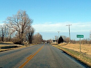
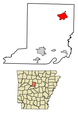
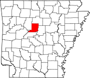
Maysville is an unincorporated community and census-designated place (CDP) in Benton County, Arkansas, United States. It is the westernmost settlement in the state of Arkansas. Per the 2020 census, the population was 117. It is located in the Northwest Arkansas region.

<span class="mw-page-title-main">New Blaine, Arkansas</span> Census-designated place in Arkansas, United States

New Blaine is an unincorporated community and census-designated place (CDP) in Logan County, Arkansas, United States. Per the 2020 census, the population was 173.

<span class="mw-page-title-main">Kingston, Arkansas</span> Census-designated place in Arkansas, United States

Kingston is an unincorporated community and census-designated place (CDP) in northeast Madison County, Arkansas, United States. It was first listed as a CDP in the 2020 census with a population of 97.

Springfield is an unincorporated community and census-designated place (CDP) located in the north central part of Arkansas in Conway County. It was first listed as a CDP in the 2020 census with a population of 223.

<span class="mw-page-title-main">Avilla, Arkansas</span> Census-designated place in Arkansas, United States

Avilla is a census-designated place in Saline County, Arkansas, United States. Per the 2020 census, the population was 1,325.

<span class="mw-page-title-main">Hagarville, Arkansas</span> Census-designated place in Arkansas, United States

Hagarville is a census-designated place in Johnson County, Arkansas, United States. Per the 2020 census, the population was 142.

<span class="mw-page-title-main">Lost Bridge Village, Arkansas</span> Census-designated place in Arkansas, United States

Lost Bridge Village is a residential subdivision near the town of Garfield in Benton County, Arkansas, United States. Per the 2020 census, the population was 397. It is located in the Northwest Arkansas region.

<span class="mw-page-title-main">Rye, Arkansas</span> Census-designated place in Arkansas, United States

Rye is a census-designated place in Cleveland County, Arkansas, United States. Per the 2020 census, the population was 123.

<span class="mw-page-title-main">Staves, Arkansas</span> Census-designated place in Arkansas, United States

Staves is a census-designated place in Cleveland County, Arkansas, United States. Per the 2020 census, the population was 133.

<span class="mw-page-title-main">Tumbling Shoals, Arkansas</span> Census-designated place in Arkansas, United States

Tumbling Shoals is a census-designated place in Cleburne County, Arkansas, United States. Per the 2020 census, the population was 902.

Woodlawn is a census-designated place in Cleveland County, Arkansas, United States. Per the 2020 census, the population was 174.

Jerusalem is an unincorporated community and census-designated place (CDP) in Conway County, Arkansas, United States. It was first listed as a CDP in the 2020 census with a population of 137. Jerusalem is located on Arkansas Highway 124, 18 miles (29 km) north-northwest of Morrilton. Jerusalem has a post office with ZIP code 72080.

References

  1. "2020 U.S. Gazetteer Files". United States Census Bureau. Retrieved October 29, 2021.
  2. 1 2 U.S. Geological Survey Geographic Names Information System: Center Ridge, Arkansas
  3. "Center Ridge CDP, Arkansas". United States Census Bureau . Retrieved April 15, 2022.
  4. "Decennial Census of Population and Housing by Decades". US Census Bureau.
  5. 1 2 "P2 Hispanic or Latino, and Not Hispanic or Latino by Race – 2010: DEC Redistricting Data (PL 94-171) – Center Ridge CDP, Arkansas". United States Census Bureau .
  6. 1 2 "P2 Hispanic or Latino, and Not Hispanic or Latino by Race – 2020: DEC Redistricting Data (PL 94-171) – Center Ridge CDP, Arkansas". United States Census Bureau .
  7. Taylor, Larry, The Encyclopedia of Arkansas History and Culture: Catholic Point (Conway County) , retrieved April 2, 2018

35°22′26″N92°33′47″W / 35.37389°N 92.56306°W / 35.37389; -92.56306