Montgomery County is a county located in the U.S. state of Ohio. As of the 2010 census, the population was 535,153, making it the fifth-most populous county in Ohio. The county seat is Dayton. The county was named in honor of Richard Montgomery, an American Revolutionary War general killed in 1775 while attempting to capture Quebec City, Canada.

Tyler County is a county in the U.S. state of West Virginia. As of the 2010 census, the population was 9,208. Its county seat is Middlebourne. The county was founded in 1814 and is named after John Tyler, Sr., father of President John Tyler.

Wayne County is a county located in east central Indiana, United States on the border with Ohio. As of the 2010 census, the population was 68,917. The county seat is Richmond.

Centerville is a town in Center Township, Wayne County, in the U.S. state of Indiana. The population was 2,552 at the 2010 census.

Centerville is an unincorporated community in Montgomery County in the southwest region of the U.S. commonwealth of Virginia.
Wayne Township is one of the eleven townships of Warren County, Ohio, United States. It is located in the northeast part of the county and includes the village of Waynesville, Ohio. Its population in 2000 was 7,250, up from 5,744 in 1990; 4,436 of this total lived in the unincorporated portions of the township. Waynesville is noted for its antique stores and is the home of a sauerkraut festival. Caesar Creek State Park is located here.

State Route 114 is a primary state highway in the U.S. state of Virginia. Known as Peppers Ferry Road, the state highway runs 10.32 miles (16.61 km) from U.S. Route 11 in Fairlawn east to US 460 in Christiansburg. SR 114 is the northernmost of three east–west highways between Radford and Christiansburg and the most direct highway between Radford and Blacksburg. The state highway also connects those cities with the Radford Army Ammunition Plant.

Washington Township is the largest of nine townships of Montgomery County, Ohio, United States. As of the 2010 census, the population was 56,607, with 32,610 persons residing within the unincorporated portion of the township, and 23,997 persons residing within the city of Centerville.
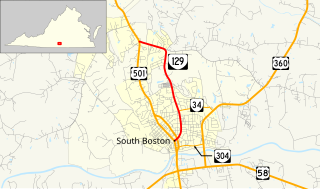
State Route 129 is a primary state highway in the U.S. state of Virginia. The state highway runs 3.18 miles (5.12 km) from U.S. Route 501 in South Boston north to US 501 at Centerville. SR 129 is the old alignment of US 501 and its predecessor, old SR 18, in central Halifax County.

State Route 176 is a primary state highway in the U.S. state of Virginia. Known for most of its length as Parksley Road, the state highway runs 2.58 miles (4.15 km) from SR 316 in Parksley east to U.S. Route 13 at Centerville in central Accomack County.

Centerville is an unincorporated community in Linn County, Kansas, United States. Centerville is 16.5 miles (26.6 km) west-northwest of Pleasanton. Centerville has a post office with ZIP code 66014.

Claypool is an unincorporated community in Logan County, West Virginia, United States. Claypool is located along West Virginia Route 10 and Huff Creek 3.5 miles (5.6 km) east of Man.
Stonecoal is an unincorporated community in Wayne County, West Virginia, United States. Stonecoal is located on the Tug Fork and U.S. Route 52 2.8 miles (4.5 km) north of Kermit.
Centerville may refer to the following places in the U.S. state of West Virginia:
Centerville is an unincorporated community in Tyler County, West Virginia, USA. Centerville is located along West Virginia Route 18 5.4 miles (8.7 km) southeast of Middlebourne. Centerville has a post office with ZIP code 26320; the post office uses the name Alma.
Tyler Mountain is an unincorporated community in Kanawha County, West Virginia, United States. Tyler Mountain is located at the junction of West Virginia Route 62 and West Virginia Route 501 5.5 miles (8.9 km) west-northwest of Charleston.
Pleasant Hill is an unincorporated community in Wood County, West Virginia, United States. Pleasant Hill is located on County Route 38 5.7 miles (9.2 km) south of Parkersburg.

State Route 514 is a state highway in Knox and Holmes Counties in central Ohio. 19.89 miles (32.01 km) long, it connects US 62 and the southern terminus of SR 205 in Danville to SR 226 in the community of Centerville just south of Shreve.

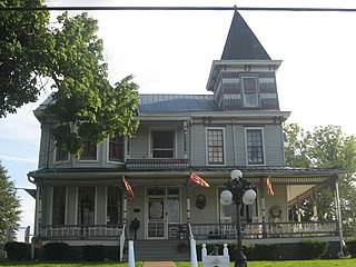
Centerville Historic District is a national historic district located at Centerville, Wayne County, Indiana. The district encompasses 115 contributing buildings in the central business district and surrounding residential sections of Centerville. It developed between about 1817 and 1873 and includes representative examples of Greek Revival, Italianate, and Federal style architecture. During this period it was county seat of Wayne County. Located in the district is the separately listed Oliver P. Morton House. Other notable contributing buildings include Morton's Row, Lantz' Row, Archway row, Tarkington Homestead, Jacob Julian House (1857), the Mansion House (1837), the Jones House, and the American House (1838–39).