Cerro Arequita

Last updated
Cerro Arequita
Arequita 01 (cropped).JPG
Cerro Arequita ca. 2011.
Highest point
Elevation 305 m (1,001 ft)
Coordinates 34°17′27″S55°16′01″W / 34.29083°S 55.26694°W / -34.29083; -55.26694
Naming
English translationCerro (Hill in Spanish); Arequita (Water falling from the high rock over the caves in Guaraní)
Language of name Spanish/Guaraní
Geography
Uruguay topographic location map.png
Red triangle with thick white border.svg
Cerro Arequita
Uruguay
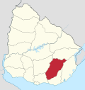
Location10 km north of Minas,
Lavalleja Department,
Uruguay
Parent range Cuchilla Grande
Geology
Mountain type Hill
Climbing
Easiest route Hike
Cerro Arequita, oil painting by Carlos Federico Saez, 1899. Arequita(1899).png
Cerro Arequita, oil painting by Carlos Federico Sáez, 1899.

Cerro Arequita is a hill located in Lavalleja Department, Uruguay.

Contents

Overview

Its name is of Guarani origin, meaning "water falling from the high rock over the caves". [1]

Since 2024 it is part of the National Park of Arequita, a nature sanctuary full of native species: armadillos, skunks, foxes, Geoffroy's cats, gray brockets, capybaras, river otters, nutrias, bats, chingolos, chalk-browed mockingbirds, dusky-legged guans, turkey vultures, savannah vultures. [2]

An endemic epiphyte flowering plant species is Tillandsia arequitae . [3]

In art

Bibliography

References

  1. Sequeira, Alejandro; Casaubou, Cristina; Olveira, Armando (July 2010). "Arequita" (PDF). Áreas protegidas del Uruguay (in Spanish). 2. Retrieved 15 February 2014.
  2. "Áreas protegidas del Uruguay - Parque Arequita" (PDF). El País (in Spanish). 2 July 2010. Retrieved 16 October 2019.
  3. "Tillandsia arequitae". Royal Botanic Gardens, Kew: World Checklist of Selected Plant Families. Retrieved 25 August 2025.