Chanchal

Last updated

Chanchal
Town
Chanchal Rajbari.jpg
Chanchal Rajbari
West Bengal location map.svg
Red pog.svg
Chanchal
Location in West Bengal, India
India location map 3.png
Red pog.svg
Chanchal
Chanchal (India)
Asia laea location map.svg
Red pog.svg
Chanchal
Chanchal (Asia)
Coordinates: 25°23′N87°59′E / 25.39°N 87.99°E / 25.39; 87.99
CountryFlag of India.svg  India
State West Bengal
District Malda
Area
  Total1.7896 km2 (0.6910 sq mi)
Population
 (2011)
  Total5,570
  Density3,100/km2 (8,100/sq mi)
Languages
  Official Bengali [1] [2]
  Additional officialEnglish [1]
Time zone UTC+5:30 (IST)
PIN
732123
Vehicle registration WB 83/WB 84
Lok Sabha constituency Maldaha Uttar
Vidhan Sabha constituency Chanchal
Website wb.gov.in

Chanchal is a census town in Malda district in the state of West Bengal, India. It is the headquarters of the Chanchal subdivision.

Contents

Geography

Chanchal
Cities, towns and locations in the northern portion of Malda district (including Chanchal subdivision and Old Malda, Habibpur, Bamangola and Gazole CD blocks)
M: municipal town, CT: census town, R: rural/ urban centre, F: Facility, H: historical centre
Owing to space constraints in the small map, the actual locations in a larger map may vary slightly

Area overview

The area shown in the adjacent map covers two physiographic regions – the Barind in the east and the tal in the west. The eastern part is comparatively high (up to 40 metres above mean sea level at places) and uneven. The soils of the eastern region are “hard salty clays of a reddish hue and the ground is baked hard as iron.” It lies to the east of the Mahananda River. The area lying to the west of the Mahananda River, the tal, is a flat low land and “is strewn with innumerable marshes, bils and oxbow lakes.” The tal area is prone to flooding by local rivers. [3] The total area is overwhelmingly rural. [4] [5] There are two important historical/ archaeological sites in the area – Pandua and Jagjivanpur. [6]

Note: The map alongside presents some of the notable locations in the area. All places marked in the map are linked in the larger full screen map.

Location

Chanchal is located at 25°23′N87°59′E / 25.39°N 87.99°E / 25.39; 87.99 . [7] Chanchal is the headquarter of the Chanchal subdivision. Also, the headquarter of the ChanchalI CD block is here. [8]

There is an announcement that Chanchal and Gazole would be amongst the 22 new municipalities to be formed in West Bengal. [9] The matter has also been reported in the press, but till November 2018, there has been no formal announcement or notification. [10]

Climate

Chanchal has three distinct seasons: summer, winter and monsoon. In summer the temperature sometimes reaches 45 degree Celsius. Winters are generally chilled and cool and sometimes temperature goes below 3 degree Celsius. During the monsoons (between June and September), the town is lashed by moderate to heavy rains.
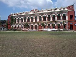
History

It was the home of Raja Saratchandra Rai Bahadur, who built the Chanchal palace. The King was married to Queen Dakshyani. One part of the palace was transformed into a government college in 1969.The other part of the Palace is now Chanchal Subdivisional Court.[ citation needed ]

Chanchal Raj Bari DSC 0244-Pano.jpg
Chanchal Raj Bari
Chanchal Sub-Divisional Court and Chanchal College Chanchal Sub Divisional Court.jpg
Chanchal Sub-Divisional Court and Chanchal College

Demographics

According to the 2011 Census of India, Chanchal had a total population of 5,570, of which 2,287 (51%) were males and 2,743 (49%) were females. Population in the age range 0–6 years was 634. The total number of literate persons in Chanchal was 4,936 (78.04% of the population over 6 years). [11]

Infrastructure

According to the District Census Handbook, Maldah, 2011, Chanchal covered an area of 1.7896 km2. The protected water-supply involved overhead tank, tube well/ borewell. It had 900 domestic electric connections, 400 road lighting points. Among the medical facilities it had 1 family welfare centre, 1 maternity & child welfare centre. Among the educational facilities, it had 1 primary school, 1 middle school, 1 secondary school, 1 higher secondary school, 1 general degree college. Among the social, cultural and recreational facilities it had 1 cinema theatre, 1 public library. [12]

Civic administration

Police station

Chanchal police station under West Bengal police has jurisdiction over Chanchal I and Chanchal II CD blocks. [13] [14]

CD block HQ

The headquarters of Chanchal I CD block is at Chanchal. [13] [15] [16]

Transport

Chanchal is on National Highway 31. [17]

Roadways

Chanchal is connected by bus services like NBSTC and private buses to cities like Balurghat, Berhampore, Siliguri, Kolkata, Asansol, Raiganj, Malda, Dinhata, Suri, Ranaghat through National Highway 31 (India).

Education

Healthcare

Chanchal Super Speciality Hospital Chanchal Super Speciality Hospital.jpg
Chanchal Super Speciality Hospital

Chanchal Super Speciality Hospital at Chanchal Roy Para, Chanchal (with blood bank and other digital facilities) is a major medical facility. There are primary health centres in Chanchal I CD Block at Kharba (with 10 beds) and Singia (Nadishik PHC) (with 10 beds). [18]

Notable people

Related Research Articles

Kharba is a village in Chanchal I CD Block in Chanchal subdivision of Malda district in the Indian state of West Bengal. The town is located on the western banks of the Mahananda River.

<span class="mw-page-title-main">Chanchal II</span> Community development block in West Bengal, India

Chanchal II is a community development block that forms an administrative division in Chanchal subdivision of Malda district in the Indian state of West Bengal.

<span class="mw-page-title-main">Chanchal I</span> Community development block in West Bengal, India

Chanchal I is a community development block that forms an administrative division in Chanchal subdivision of Malda district in the Indian state of West Bengal.

Ratua is a town in the Ratua I CD block in the Chanchal subdivision of Malda district in the state of West Bengal, India.

Harishchandrapur is a village in the Harishchandrapur I CD block in the Chanchal subdivision of Malda district in the state of West Bengal, India.

Habibpur is a village in the Habibpur CD block in the Malda Sadar subdivision of Malda district in the state of West Bengal, India.

Gazole is a town in Malda district in the Indian state of West Bengal. Gazole police station serves this city. The headquarters of Gazole block is Gazole.

Pakuahat is a village in the Bamangola CD block in the Malda Sadar subdivision of Malda district in the state of West Bengal, India.

Pukhuria is a village in the Ratua II CD block in the Chanchal subdivision of Malda district in the state of West Bengal, India.

Khanta is a village in the Harishchandrapur II CD block in the Chanchal subdivision of Malda district in the state of West Bengal, India.

Malatipur is a village in the Chanchal II CD block in the Chanchal subdivision of Malda district in the state of West Bengal, India.

Rangabhita is a census town in the Gazole CD block in the Malda Sadar subdivision of Malda district in the state of West Bengal, India.

Baksinagar is a census town in the Habibpur CD block in the Malda Sadar subdivision of Malda district in the state of West Bengal, India.

Hatimari is a village in the Gazole CD block in the Malda Sadar subdivision of Malda district in the state of West Bengal, India.

Jhangra is a census town in the Old Malda CD block in the Malda Sadar subdivision of Malda district in the state of West Bengal, India.

Chhatinamor is a census town in the Old Malda CD block in the Malda Sadar subdivision of Malda district in the state of West Bengal, India.

Araidanga is a populated place, not identified as a separate place in 2011 census, in the Ratua II CD block in the Chanchal subdivision of Malda district in the state of West Bengal, India.

Mashaldaha is a village in the Harishchandrapur II CD block in the Chanchal subdivision of Malda district in the state of West Bengal, India.

Daulatnagar is a village and a gram panchayat in the Harishchandrapur II CD block in the Chanchal subdivision of Malda district in the state of West Bengal, India.

Pipla Kasimpur is a village and a in the Harishchandrapur I CD block in the Chanchal subdivision of Malda district in the state of West Bengal, India.

References

  1. 1 2 "Fact and Figures". www.wb.gov.in. Retrieved 15 January 2019.
  2. "52nd Report of the Commissioner for Linguistic Minorities in India" (PDF). nclm.nic.in. Ministry of Minority Affairs. p. 85. Archived from the original (PDF) on 25 May 2017. Retrieved 15 January 2019.
  3. "District Census Handbook Maldah, Series 20, Part XII A" (PDF). Census of India 2011, Pages 13-15: Physiography. Directorate of Census Operations, West Bengal. Retrieved 9 November 2018.
  4. "District Statistical Handbook 2014 Malda". Table 2.1 , 2.2, 2.4b. Department of Statistics and Programme Implementation, Government of West Bengal. Retrieved 9 November 2018.
  5. "C.D. Block Wise Primary Census Abstract Data(PCA)". West Bengal – District-wise CD Blocks. Registrar General and Census Commissioner, India. Retrieved 9 November 2018.
  6. "District Census Handbook Maldah, Series 20, Part XII A" (PDF). Census of India 2011, Page 98: Brief Description of Places of Religious, Historical or Archaeological Importance and Places of Tourist Interest of the District. Directorate of Census Operations, West Bengal. Retrieved 9 November 2018.
  7. "Yahoo maps location of Chanchal". Yahoo maps. Retrieved 7 December 2008.
  8. "Contact details of Block Development Officers". Malda district. Panchayats and Rural Development Department, Government of West Bengal. Retrieved 26 December 2008.[ permanent dead link ]
  9. "Decentralisation of Governance: 22 new municipalities to come up in Bengal". All India Trinamool Congress. Archived from the original on 4 July 2018. Retrieved 23 October 2018.
  10. "West Bengal to have 22 new municipalities". Outlook 11 June 2014. Retrieved 23 October 2018.
  11. "District Census Handbook, Maldah , Series 20, Part XII B" (PDF). Rural PCA-C.D. blocks wise Village Primary Census Abstract, location no. 312245, pages 26-27. Directorate of Census Operations West Bengal. Retrieved 12 August 2021.
  12. "District Census Handbook Maldah, Census of India 2011, Series 20, Part XII A" (PDF). Section II Town Directory, Pages 775-786; Statement I: Status and Growth History, Page 775; Statement III: Civic & Other Amenities, Pages 779-780; Statement IV: Medical Facilities 2009, Pages 781-782; Section V: Educational, Recreational and Cultural Facilities: Pages 783-785; Statement VI: Industry & Banking, Page 786. Directorate of Census Operations, West Bengal. Retrieved 8 August 2021.
  13. 1 2 "District Statistical Handbook 2014 Malda". Table 2.1, 2.2, 2.4b. Department of Statistics and Programme Implementation, Government of West Bengal. Archived from the original on 21 January 2019. Retrieved 9 November 2018.
  14. "Malda District Police". Telephone Numbers. District Police. Archived from the original on 9 November 2018. Retrieved 9 November 2018.
  15. "District Census Handbook: Maldah, Series 20 Part XII A" (PDF). Map of Maldah with CD Block HQs and Police Stations (on the fourth page). Directorate of Census Operations, West Bengal, 2011. Retrieved 9 November 2018.
  16. "BDO Offices under Malda District". Department of Mass Education Extension & Library Services, Government of West Bengal. West Bengal Public Library Network. Archived from the original on 12 October 2018. Retrieved 8 November 2018.
  17. Google maps
  18. "Health & Family Welfare Department". Health Statistics. Government of West Bengal. Archived from the original on 28 October 2021. Retrieved 14 November 2018.