
Almoloya de Juárez is a town in the State of Mexico and the seat of the municipality of Almoloya de Juárez. The name Almoloya comes from the Nahuatl, that is properly Almoloyan, composed of: atl, "water"; molo "impersonal voice of moloni, to flow the source" and yan, "place"; that it means "place where flows the water source".
Ixtapaluca is a city and a municipality in the eastern part of the State of Mexico in Mexico. It lies between the Federal District and the western border of the state of Puebla. The name Ixtapaluca means "Where the salt gets wet".

Ciudad Nicolás Romero is the largest city and municipal seat of the municipality of Nicolás Romero in State of Mexico, Mexico. It is located 58 km from the city of Toluca, the state capital and lies in the north-central part of the state, just northwest of the Federal District. The seat/municipality's current name is to honor Nicolás Romero, who fought for Benito Juárez during the Reform War and the French intervention in Mexico. He was executed there by the French. The town adopted this name in 1898. The area was settled by the Otomi and named Azcapotzaltongo by the Aztecs after conquering it. During colonial times, it was known as San Pedro Azcapotzaltongo. It was then called Monte Bajo from 1821 to 1898, when the current name was adopted. Both the municipality and city are commonly referred to as Nicolás Romero.

San Juan Bautista Tuxtepec, or simply referred to as Tuxtepec, is the head of the municipality by the same name and is the second most populous city of the Mexican state of Oaxaca. It is part of the Tuxtepec District of the Papaloapan Region. As of the 2020 census, the city is home to a population of 103,609 and 159,452 in the municipality, though census data are often under reported for various reasons. The municipality resides in the region called La Cuenca, is located 36 feet above sea level, and occupies an area of approximately 580 square miles (1,500 km2). The city itself is surrounded by the Papaloapan River, and lies a few kilometers south of the Cerro de Oro Dam on its tributary the Santo Domingo River. The municipality is bordered by the state of Veracruz in the north, the municipalities of Loma Bonita to the east and San José Chiltepec to the south. It is almost 100 miles (160 km) to the port of Veracruz, 130 miles (210 km) to Oaxaca City, the state capital, and 310 miles (500 km) to Mexico City.

The Albuquerque–Santa Fe–Las Vegas combined statistical area is made up of eight counties in north central New Mexico. The combined statistical area consists of the Albuquerque and Santa Fe metropolitan statistical areas, and the Las Vegas, Los Alamos, and Española micropolitan statistical areas. The 2013 delineations included the Grants micropolitan statistical area, but it was removed in the 2018 revisions. As of the 2010 census, the CSA had a population of 1,146,049. The population of the CSA is 1,178,664 as of the July 1, 2018 Census Bureau estimate. Roughly 56% of New Mexico's residents live in this area. Prior to the 2013 redefintions, the CSA consisted only of the Santa Fe metropolitan statistical area and the Española micropolitan statistical area. The total land area of the Albuquerque–Santa Fe–Las Vegas combined statistical area in the 2013 definition is 26,421 sq. mi.
Tultepec is a city and municipality located in State of Mexico, Mexico. It lies directly north of Mexico City in the northeastern part of the State of Mexico, making it part of the Greater Mexico City urban area. The name comes from Náhuatl meaning 'hill of the 'tule'. The census of 2005 reported a population of 57,586 for the city and 110,145 for the municipality as a whole.

Tlaxiaco is a city, and its surrounding municipality of the same name, in the Mexican state of Oaxaca. It is located in the Tlaxiaco District in the south of the Mixteca Region, with a population of about 17,450.

Tlatlaya is a small town and municipality located in the southeast of the State of Mexico in Mexico. The word “Tlatlaya” means when the hearth is black and red.
Jiquipilco Municipality is one of the municipalities of the State of Mexico in Mexico. It is north of the Toluca Valley, part of the region consisting of the southern and western slopes of Cerro La Catedral, which has a concentration of speakers of the Otomi language. It is about 40 km from Toluca, the state capital. The name is a corruption of Nahuatl “Xiquipilli”, meaning “the place of saddlebags”. Jiquipilco is situated on the transversal volcanic axis that crosses Mexico in an area surrounded by lakes and volcanoes. This portion is called "Anahuac”.
Huautla de Jimenez is a town and municipality in the Mexican state of Oaxaca. It is part of the Teotitlán District in the north of the Cañada Region.
Aculco is a municipality located in the Atlacomulco Region of the State of Mexico in Mexico. The municipality is located to northwestern Mexico State. The name comes from Nahuatl. The municipal seat is the town of Aculco de Espinoza, although both the town and municipality are commonly referred to as simply "San Jerónimo Aculco".

Acambay is a town and municipio (municipality) located in northern State of Mexico. The township of Acambay is the municipal seat of the municipio of the same name.
San Jose Villa de Allende is a town and seat of the municipality of Villa de Allende located 70 kilometers to the west of the city of Toluca. Villa de Allende was named in honor of Ignacio Allende, a hero of the Mexican War of Independence.
Ixtlahuaca de Rayón is a city and municipality north of Toluca in the northwest part of the State of Mexico, in Mexico. The distance between Mexico City and Ixtlahuaca is 32 km. The name Ixthahuaca comes from Náhuatl and means plains without trees. The city and municipality were officially established by decree on November 14, 1816 by the Congress of the State of Mexico.

Jilotepec de Molina Enríquez and Jilotepec de Abasolo are a town and a municipality located northwest zone of the State of Mexico, in Mexico. However, both entities are interchangeably referred to as "Jilotepec". This name comes from Náhuatl, meaning "hill of corncobs". It is located in hilly and forested terrain an hour from Mexico City, Toluca, 40 minutes from San Juan del Río, 30 minutes from Tula and 20 from Tepeji. The Mexico City–Querétaro and the new Transoceanic Freeways converge within its territory that unite the coasts of Mexico from Veracruz to Michoacán.
Tepetlaoxtoc de Hidalgo is a town and the seat of the municipality of Tepetlaoxtoc, which contains the archeological site of Tepetlaoxtoc, in the State of Mexico in Mexico. The name Tepetlaoxtoc comes from Náhuatl and means in limestone caves, and is used interchangeably to refer to the town, the municipality and the archeological ruins. 'de Hidalgo' was added to the town's name to honor Miguel Hidalgo who began the Mexican War of Independence. It is located about 100 km northeast of Mexico City.

Tonaya is a town and municipality, in Jalisco in central-western Mexico. The municipality covers an area of 463.67 km2.

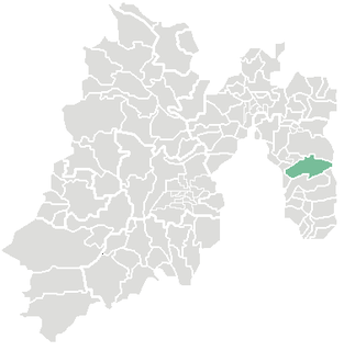
Tlalmanalco is a town and municipality located in the far south-eastern part of the State of Mexico. The name is from the Nahuatl language, meaning “flat area.” The municipality's seal shows flat land, with a pyramid on it, representing its pre-Hispanic history, surrounded by small mountains, which is how the area was represented in Aztec codices. The municipality is bordered by the municipalities of Chalco, Ixtapaluca, Cocotitlan, Temamatla, Tenango del Aire, Ayapango and Amecameca. It also shares a border with the neighboring state of Puebla. Much of the municipality borders the Iztaccihuatl-Popocatepetl National Park. For this reason, Iztaccihuatl volcano dominates the landscape. The town has been designated as a “Pueblo con Encanto” by the government of the State of Mexico.

Villa del Carbón is a town and municipality located in the northern part of Mexico State, just northwest of Mexico City. While the town of Villa del Carbón is the largest in the municipality, it is not the oldest. The municipality contains a number of villages of Otomí and Nahua origins, in which much of the indigenous culture still survives. The municipality's territory was defined in 1714 when a region known as Chiapan, split into what is now Chapa de Mota and Villa del Carbón. At that time, however, the community which is now a municipal seat did not have an official name; it was known first only by the name of its church Nuestra Señora de la Peña de Francia, and later by being a major supplier of charcoal. This would lead to the name of Villanueva del Carbón de Nuestra Señora Santa María de la Peña de Francia, which eventually shortened to Villa del Carbón. The major portions of the municipality's glyph, which serves as it coat-of-arms, does not reflect the town of Villa del Carbón but rather two of its oldest communities: Taxhimay and San Lorenzo Pueblo Nuevo.
Otumba is a municipio (municipality) of State of Mexico in Mexico. The municipal seat and largest settlement is Otumba de Gómez Farías. The municipality of Otumba has a land area of some 143.42 square kilometres (55 sq mi), and a population recorded in the intermedial 2005 census, the Conteo de Población y Vivienda, of 29,873.

