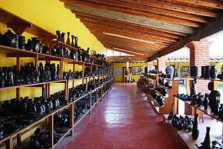
Barro negro pottery is a style of pottery from Oaxaca, Mexico, distinguished by its color, sheen and unique designs. Oaxaca is one of few Mexican states which is characterized by the continuance of its ancestral crafts, which are still used in everyday life. Barro negro is one of several pottery traditions in the state, which also include the glazed green pieces of Santa María Atzompa; however, barro negro is one of the best known and most identified with the state. It is also one of the most popular and appreciated styles of pottery in Mexico. The origins of this pottery style extends as far back as the Monte Alban period and for almost all of this pottery's history, had been available only in a grayish matte finish. In the 1950s, a potter named Doña Rosa devised a way to put a black metallic like sheen onto the pottery by polishing it before firing. This look has made the pottery far more popular. From the 1980s to the present, an artisan named Carlomagno Pedro Martínez has promoted items made this way with barro negro sculptures which have been exhibited in a number of countries.
Teoloyucan is a city and municipality located in State of Mexico, Mexico. It lies 45 km north of the Federal District in the northeastern part of the state of México, and is part of the Greater Mexico City urban area. During the colonial period the area's name had a number of variations, including Teohuilloyocan, Teohuilloyucan, Theoloyucan, Teoloyucan Coaquileque and Tehuilloyocan. The name comes from Nahuatl meaning place of glass or place of crystal rock.

Zumpango is a municipality located to northeastern part of the state of Mexico in Zumpango Region. It lies directly north of the Mexico City within the Greater Mexico City urban area. This area is under rapid development large scale housing projects; however, transportation and other infrastructure have not kept up with the growing population. The city of Zumpango lies near Lake Zumpango, the last of the five interconnected lakes which covered much of the Valley of Mexico in the pre Hispanic period. The name Zumpango is derived from the Nahuatl word “Tzompanco” which means string of scalps.

Tultepec is a city and municipality located in State of Mexico, Mexico. It lies directly north of Mexico City in the northeastern part of the State of Mexico, making it part of the Greater Mexico City urban area. The name comes from Náhuatl meaning 'hill of the 'tule'. The census of 2005 reported a population of 57,586 for the city and 110,145 for the municipality as a whole.

Tepotzotlán is a city and a municipality in the Mexican state of Mexico. It is located 40 km (25 mi) northeast of Mexico City about a 45-minute drive along the Mexico City-Querétaro at marker number 41. In Aztec times, the area was the center of a dominion that negotiated to keep most of its independence in return with being allied with the Aztec Triple Alliance. Later, it would also be part of a "Republic of the Indians," allowing for some autonomy under Spanish rule as well. The town became a major educational center during the colonial period when the Jesuits established the College of San Francisco Javier. The college complex that grew from its beginnings in 1580 would remain an educational center until 1914. Today this complex houses the Museo del Virreinato, with one of the largest collections of art and other objects from this time period.

Tequixquiac is a municipality located in the Zumpango Region of the State of Mexico in Mexico. The municipality is located 84 kilometres (52 mi) north of Mexico City within the valley that connects the Valley of Mexico with the Mezquital Valley. The name comes from Nahuatl and means "place of tequesquite waters". The municipal seat is the town of Santiago Tequixquiac, although both the town and municipality are commonly referred to as simply "Tequixquiac".

Huehuetoca is a municipio (municipality) in State of Mexico, central Mexico, and also the name of its largest town and municipal seat.

Animas Trujano is a town and municipality in Oaxaca in south-western Mexico. The municipality covers an area of 6.7 km², and it is part of the Centro District in the Valles Centrales region. Its climate is warm most of the time, and the municipal area has a diversity of both animal and plant species. As of 2005, the municipality had a total population of 3189, the majority of them being Catholic. Approximately 69 people speak an indigenous language, according to the 2005 INEGI census. The origin of the name "Animas Trujano" dates to the times of the Mexican War of Independence. Originally, the municipality was just called "Animas", but people decided to add the word "Trujano" in honor to Valerio Trujano. He spent a little time in Animas, but then he was executed by the Spanish royalist army during the Mexican War of Independence. One of the attractions of Animas Trujano is the "Danza de la Pluma". People also celebrate the feast day of the Virgin of Guadalupe on December 12, a festival in honor of the Virgin of Rosario, the Holy Week and more.

San Bartolo Coyotepec is a town and municipality located in the center of the Mexican state of Oaxaca. It is in the Centro District of the Valles Centrales region about fifteen km south of the capital of Oaxaca.

Santa María Coyotepec is a town and municipality in Oaxaca in southern Mexico. The municipality covers an area of km². It is part of the Centro District in the Valles Centrales region. As of 2005, the municipality had a total population of 2070.
Otumba is a municipio (municipality) of State of Mexico in Mexico. The municipal seat and largest settlement is Otumba de Gómez Farías. The municipality of Otumba has a land area of some 143.42 square kilometres (55 sq mi), and a population recorded in the intermedial 2005 census, the Conteo de Población y Vivienda, of 29,873.

Coyotepec (municipality) is a town and municipality in Puebla in south-eastern Mexico.

Centro District is located in the Valles Centrales Region of the State of Oaxaca, Mexico. The district includes the state capital Oaxaca and satellite towns. The district has an average elevation of 1,550 meters. The climate is mild, with average temperatures ranging from 16°C in Winter to 25°C in spring.

The Museo Estatal de Arte Popular de Oaxaca or MEAPO is a small museum in the municipality of San Bartolo Coyotepec just south of the city of Oaxaca in Mexico. It is run by the state of Oaxaca to showcase the entity's handcrafts and folk art tradition, through its permanent collection, online “cyber-museum,” collaboration with national and international entities, and sponsorship of events such as craft markets, conferences, and temporary exhibitions. It is dedicated to the crafts and to the artisans and the cultures behind the items. Its collection contains samples of most of the crafts produced in the state, especially the Central Valleys region, but most of its collection consists of barro negro pottery, the specialty of San Bartolo Coyotepec. It is run by director Carlomagno Pedro Martínez, a recognized artisan and artist in barro negro.

Carlomagno Pedro Martínez is a Mexican artist and artisan in “barro negro” ceramics from San Bartolo Coyotepec, in the Mexican state of Oaxaca. He comes from a family of potters in a town noted for the craft. He began molding figures as a child and received artistic training when he was 18. His work has been exhibited in Mexico, the U.S. and Europe and he has been recognized as an artist as well as an artisan. Today, he is also the director of the Museo Estatal de Arte Popular de Oaxaca (MEAPO) in his hometown. In 2014, Martínez was awarded Mexico's National Prize for Arts and Sciences

Doña Rosa, full name Rosa Real Mateo de Nieto, was a Mexican ceramics artisan from San Bartolo Coyotepec, Oaxaca, Mexico. She is noted for inventing a technique to make the local pottery type, barro negro, black and shiny after firing. This created new markets for the ceramics with collectors and tourists.

Mexican handcrafted fireworks production is mostly concentrated in the State of Mexico in central Mexico. The self-declared fireworks capital of Mexico is Tultepec, just north of Mexico City. Although the main ingredient for fireworks, gunpowder, was brought by the conquistadors in the 16th century, fireworks became popular in Mexico in the 19th century. Today, it is Latin America’s second largest producer, almost entirely for domestic use, with products ranging from small firecrackers to large shells and frames for pyrotechnics called “castillos” (castles) and “toritos”. The industry is artisanal, with production concentrated in family-owned workshops and small factories with a number operating illegally. The relatively informal production and sales of fireworks have made it dangerous with a number of notable accidents in from the late 1990s to the present, despite attempts to safety regulations.

Region IV is an intrastate region within the State of Mexico. It lies to the north of Mexico City, in the Valley of Mexico, bordering the state of Hidalgo. The whole region is one of the ten in the state which form part of the Metropolitan Area of the Valley of Mexico, although Villa del Carbón is not included in the definition of the metropolitan area.

Oaxaca handcrafts and folk art is one of Mexico's important regional traditions of its kind, distinguished by both its overall quality and variety. Producing goods for trade has been an important economic activity in the state, especially in the Central Valleys region since the pre-Hispanic era which the area laid on the trade route between central Mexico and Central America. In the colonial period, the Spanish introduced new raw materials, new techniques and products but the rise of industrially produced products lowered the demand for most handcrafts by the early 20th century. The introduction of highways in the middle part of the century brought tourism to the region and with it a new market for traditional handcrafts. Today, the state boasts the largest number of working artisans in Mexico, producing a wide range of products that continue to grow and evolve to meet changing tastes in the market.


