Related Research Articles

The Municipalities of Colombia are decentralized subdivisions of the Republic of Colombia. Municipalities make up most of the departments of Colombia with 1,122 municipalities (municipios). Each one of them is led by a mayor (alcalde) elected by popular vote and represents the maximum executive government official at a municipality level under the mandate of the governor of their department which is a representative of all municipalities in the department; municipalities are grouped to form departments.

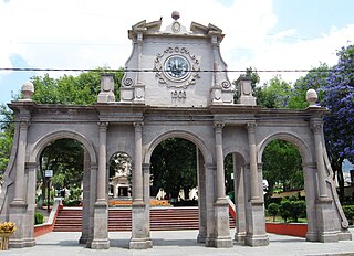
Almoloya de Juárez is a town in the State of Mexico and the seat of the municipality of Almoloya de Juárez. The name Almoloya comes from the Nahuatl, that is properly Almoloyan, composed of: atl, "water"; molo "impersonal voice of moloni, to flow the source" and yan, "place"; that it means "place where flows the water source".
Ixtapaluca is a city and a municipality in the eastern part of the State of Mexico in Mexico. It lies between the Federal District and the western border of the state of Puebla. The name Ixtapaluca means "Where the salt gets wet".

Ciudad Nicolás Romero is the largest city and municipal seat of the municipality of Nicolás Romero in State of Mexico, Mexico. It is located 58 km from the city of Toluca, the state capital and lies in the north-central part of the state, just northwest of the Federal District. The seat/municipality's current name is to honor Nicolás Romero, who fought for Benito Juárez during the Reform War and the French intervention in Mexico. He was executed there by the French. The town adopted this name in 1898. The area was settled by the Otomi and named Azcapotzaltongo by the Aztecs after conquering it. During colonial times, it was known as San Pedro Azcapotzaltongo. It was then called Monte Bajo from 1821 to 1898, when the current name was adopted. Both the municipality and city are commonly referred to as Nicolás Romero.
Huixquilucan Municipality is one of the municipalities in State of Mexico, Mexico. It lies adjacent to the west side of the Federal District and is part of Greater Mexico City but independent of Mexico City itself. The name "Huixquilucan" comes from Nahuatl meaning, "place full of edible thistles."

San Juan Bautista Tuxtepec, or simply referred to as Tuxtepec, is the head of the municipality by the same name and is the second most populous city of the Mexican state of Oaxaca. It is part of the Tuxtepec District of the Papaloapan Region. As of the 2020 census, the city is home to a population of 103,609 and 159,452 in the municipality, though census data are often under reported for various reasons. The municipality resides in the region called La Cuenca, is located 36 feet above sea level, and occupies an area of approximately 580 square miles (1,500 km2). The city itself is surrounded by the Papaloapan River, and lies a few kilometers south of the Cerro de Oro Dam on its tributary the Santo Domingo River. The municipality is bordered by the state of Veracruz in the north, the municipalities of Loma Bonita to the east and San José Chiltepec to the south. It is almost 100 miles (160 km) to the port of Veracruz, 130 miles (210 km) to Oaxaca City, the state capital, and 310 miles (500 km) to Mexico City.
Villa Guerrero is a municipality in the State of Mexico, Mexico. The municipal seat is the town of Villa Guerrero. It is located on the southern slopes of the Nevado de Toluca, also known as Xinantecatl, and is 50 minutes/58 km from Toluca.

Tlatlaya is one of 125 municipalities of the State of Mexico in Mexico. The municipal seat is the town of Tlatlaya which is the eleventh largest town in the municipality. The word “Tlatlaya” means when the hearth is black and red.
Jiquipilco Municipality is one of the municipalities of the State of Mexico in Mexico. It is north of the Toluca Valley, part of the region consisting of the southern and western slopes of Cerro La Catedral, which has a concentration of speakers of the Otomi language. It is about 40 km from Toluca, the state capital. The name is a corruption of Nahuatl “Xiquipilli”, meaning “the place of saddlebags”. Jiquipilco is situated on the transversal volcanic axis that crosses Mexico in an area surrounded by lakes and volcanoes. This portion is called "Anahuac”.
Aculco is a municipality located in the Atlacomulco Region of the State of Mexico in Mexico. The municipality is located to northwestern Mexico State. The name comes from Nahuatl. The municipal seat is the town of Aculco de Espinoza, although both the town and municipality are commonly referred to as simply "San Jerónimo Aculco".
Donato Guerra is one of 125 municipalies in the State of Mexico, Mexico. It's municipal seat is the town of Villa Donato Guerra, which is the 13th largest town in the municipality of Donato Guerra. The area is also known as Malacatepec and La Asunción Malacatepec. (Villa) Donato Guerra is located in the western part of the State of Mexico. In the region that is identified with Valle de Bravo. The town was named in 1880 in honor of Donato Guerra, a distinguished soldier of the War of La Reforma. It is located around 77 kilometers from Toluca which is the capital of the state, on Federal Highway number 35 Mexico City - Zitácuaro.

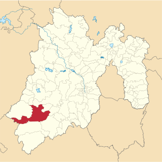
El Oro is one of 125 municipalities in the State of Mexico. The county seat is the town of El Oro de Hidalgo. The name El Oro, is not from Nahuatl, like most other municipality names in the state, but from Spanish, and simply means "the gold." It has subsequently been given an alternative Nahuatl name of "Teocuitlatl," meaning "sacred excrement," referring to gold. Its seal, in the form of an Aztec glyph, contains elements referring to gold and to caves, of which there are many in the municipality. The municipality is located in the northwest of the State of Mexico, 96 km from the state capital of Toluca, and is bounded by the municipalities of Temascalcingo to the north, Jocotitlán to the east, San Felipe del Progreso and San José del Rincón to the south, and by the state of Michoacán to the west. As of 2005, the municipal seat with the formal name of El Oro de Hidalgo had a population of 5,797, and the municipality of El Oro had a population of 31,847. While it made its name as a major gold and silver mining town from the 17th to the early 20th centuries, the mines have since been tapped out and the town is turning to tourism for economic development.
Ixtlahuaca de Rayón ,is a city, municipal seat and 5th largest city in the municipality of Ixtlahuaca north of Toluca in the northwest part of the State of Mexico, in Mexico. The distance between Mexico City and Ixtlahuaca is 32 km. The name Ixthahuaca comes from Náhuatl and means plains without trees. The city and municipality were officially established by decree on November 14, 1816 by the Congress of the State of Mexico.
Tejupilco is a municipality in the State of Mexico, Mexico, located approximately 100 kilometres (62 mi) southwest of the state capital Toluca, along Federal Highway 34. Its municipal seat is Tejupilco de Hidalgo. The municipality has a total area of about 1,327 km2 (512 sq mi), with a contrasting topography ranging from deep ravines and canyons to high ridges; the highest elevation within the municipality reaches some 1,117 metres (3,660 ft) asl. The 2005 census recorded a population of 62,547 inhabitants.
Temascalcingo is one of 125 municipalities in the State of Mexico, Mexico. The municipal seat is the town of Temascalcingo de José María Velasco. It is located in the northeast of the state. The temazcal was very common in Temascalcingo. The name Temascalcingo has its roots in Nahuatl. It means place of the little temazcal. The town is one of the "Pueblo con Encanto" of the State of Mexico.
Luvianos is a small town and municipality located in the southwest of the State of Mexico. It gained municipal status in 2000. People can access Luvianos by driving Federal Road 134 south from Toluca, and then take a detour about 25 minutes north of Tejupilco. The name is derived from a hacienda what was established during colonial times.

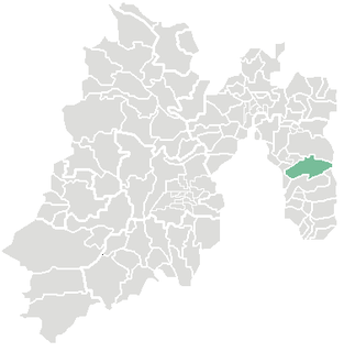
Santiago Papasquiaro is one of the 39 municipalities of Durango, in north-western Mexico. The municipal seat lies at Santiago Papasquiaro. The municipality covers an area of 7,238.4 km². Santiago Papasquiaro municipality is at an average height of 1,730 m (5,675 ft) over the sea-level. The municipality lies east from Sierra Madre Occidental Mountain Range. It neighbors with other municipalities: Canelas and Tepehuanes municipalities at the north; San Dimas and Otáez, south; Nuevo Ideal to the east, Tamazula to the west and El Oro located northeast.
Otumba is a municipality in the State of Mexico in Mexico. The municipal seat and largest town is Otumba de Gómez Farías. The municipality of Otumba has a land area of some 143.42 square kilometres (55 sq mi), and a population recorded in the intermedial 2005 census, the Conteo de Población y Vivienda, of 29,873.
References
- 1 2 3 4 5 6 7 "Enciclopledia de los Municipios de Mexico Estado de Mexico Villa de Allende". Archived from the original on May 27, 2007. Retrieved 2008-05-06.
- 1 2 "Principales resultados por localidad 2005 (ITER)". Archived from the original on 2011-06-13. Retrieved 2008-03-24.
