Zacualpan, State of Mexico

Last updated
Zacualpan

Zacualpan
Zacualpan.svg
Seal
Motto(s): 
A corner close to Heaven
Mexico Estado de Mexico Zacualpan location map.svg
Location of the municipality in the State of Mexico
Mexico States blank map.svg
Red pog.svg
Zacualpan
Location in Mexico
Coordinates: 18°43′17″N99°49′30″W / 18.72139°N 99.82500°W / 18.72139; -99.82500
CountryFlag of Mexico.svg  Mexico
State Mexico (state)
Municipal SeatZacualpan
Government
   Municipal President Fidel Figueroa Gómez (2019-2021) Partido Nueva Alianza (Mexico).svg
Area
  Total305.5 km2 (118.0 sq mi)
Elevation
2,710 m (8,890 ft)
Population
 (2010)
  Total15,121
  Density49.62/km2 (128.5/sq mi)
Time zone UTC-6 (Central Standard Time)
  Summer (DST) UTC-5 (Central Daylight Time)
ZIP code
51800
Area code(s) 721
Website www.facebook.com/zacualpanemexico

Zacualpan is one of the 125 municipalities in the State of Mexico in Mexico. It's municipal seat and largest settlement is the town of Zacualpan. It's located to the South of the state sharing a border with the State of Guerrero, 40 minutes from Ixtapan de la Sal, 1 hour and 50 minutes from the city of Toluca (the State's Capital), and 2 and a half hours from Mexico City. The municipality covers an area of 305.5 km² (1.35% of the area of the State of Mexico). Zacualpan is delimited to the North by the municipalities of Almoloya de Alquisiras and Coatepec Harinas, to the East by Ixtapan de la Sal and the municipality of Pilcaya (Guerrero), to the West by Sultepec, and to the South by Pilcaya, Tetipac, and Pedro Ascencio de Alquisiras (Guerrero).

Contents

The official name of the capital of the municipality is Real de Minas Zacualpan. The capital of the municipality was the first mining town established in the American Continent and mining is still an important economic activity in the life of its inhabitants. Due to its mining roots, its colonial buildings, and its landscape, Zacualpan was named "Pueblo con Encanto" (A Town with Charm) between 2006 and 2009.

The Spanish opened silver mines here around 1540. [1]

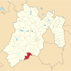
As of 2005, the municipality had a total population of 13,800. [2]

Etymology

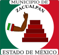
The name of Zacualpan comes from the nahuatl words tzacualli (something that hides, stores, or conceals) and pan (on or above). The hieroglyph that represents the town's seal contains two figures: a 5-step pyramid and an open hand above it. In the Codex Mendoza, the meaning of this hieroglyph has been established as A place where valuable objects are stored. [3]

History

Zacualpan has a long history that goes back to the Pleistocene: the region was inhabited by large mammals such as mastodons, and perhaps some human nomads and hunters established their communities all around the southern region of the State of Mexico.

Prehispanic Period

The Couixcas arrived to the territory that nowadays is Zacualpan around the 12th century. When this group arrived there were already some settlements of Chontales, Matlazincas, and Mazatecas. The migration of the Couixcas seems to have come from what nowadays is the state of Michoacan. For this reason, the oldest cities founded by the Couixca group are found to the west of the region: Sultepec is older than Zacualpan and Zacualpan is older than the towns founded towards the region of Malinalco. After the Couixcas settled in the region, they coexisted with the already settled groups (Matlazincas, Chontales, Mazatecos, etc.) but became the dominant group. [4]

Colonial Period

The first contact between the Couixcas and the Spaniards occurred in November, 1519: Hernan Cortes had sent a delegation under Gonzalo de Umbria and a group of Spaniards and guides provided by Moctezuma Xocoyotzin to survey the existing gold mines in the domain of Zacatula, (Zacatotlan). The shortest known path between Mexico-Tenochtitlan and Zacatula crossed what nowadays is Zacualpan. This route had been used since the beginning of the establishment of Teotihuacan by the toltecas coming from Tula between VII and X AC. Its main purpose was commerce between the villages and cities of the valley of Mexico and the Pacific coast. [4]

The second contact between the Couixcas and the Spaniards happened at the beginning of 1520, when Cortes demanded a tax in gold and silver from all villages through the use of native tax collectors accompanied by Spaniards. This tax was destined to be sent back to Spain then under the reign of Charles V. In 1521, the governors of Matlazingo, Malinalco, and Couixco asked Cortes to make them his vassals [4]

Around that time, it was forbidden and under penalty of death to establish Spanish towns in close contact with indigenous towns. Each new Spanish town was named Real de Minas, and the purpose of these new towns was to exploit the mines found in the adjacent region. Under these conditions, the following Spanish towns were formed: San Esteban del Puerto, Nueva Villa Rica, Medellín Villa de Espíritu Santo, Real of San Lorenzo de Tetzicapan, Real of the Mines of Zacualpan, and the Real of San Salvador of Ayotuxco (also belonging to the mines of Zacualpan). Each Real had a nearby town inhabited by indigenous servants: the Real of Zacualpan had the town of Zotzocola; the Real of Ayotuxco had the town of Cuevillas, and the Real of Tetzicapan had the town of Coloxtitlan. The mines of Zacualpan were worked by indigenous slaves, African slaves, and indigenous workers that were forced to pay the taxes imposed by the Spaniards through their work. [4]

In 1536, the King Charles V sent a group of German experts in mining techniques and metallurgy from the Fugger dynasty with the objective of teaching the Spaniards the newest mining and metallurgy techniques. These experts produced the first alloy of silver minerals in the Hacienda of Nombre de Dios. The first alloy haciendas where established in Zacualpan in 1562 [4]

Independence

During the Mexican War of Independence (1810-1821), the government in Zacualpan was in charge of Manuel de la Concha, who at one point, abandoned the town and came back between 1816 and 1817 under the protection of the lieutenant colonel Manuel Gomez Pedraza and the second lieutenant colonel Mateo Cuitly from the royalist army. At the same time, Pedro Ascencio de Alquisiras conducted a guerrilla warfare in the region, establishing his headquarters in Zacualpan on March 12, 1821. He abandoned the region on June 2 and died during an ambush in Tetecala, Morelos. It is unknown who was left in charge of the government of Zacualpan (perhaps the task fell into the hands of is second-in-command Felipe Martinez). [4]

Mexican Revolution to the Present

At the beginning of the Mexican Revolution, there were 17 small businesses in charge of the existing 40 mines. In 1919, the mine of El Alacran reached peak production and in 1927 consisted of 9 levels with a depth of 300 meters underground. In 1921, the mine of San Fernando reached a modest peak of production too [4]

The census of 1930 reported that the population in Zacualpan had grown to 2,865 inhabitants with 25% of them dedicated to mining activities. By this time, no native dialects were spoken anymore. [4]

Related Research Articles

Guerrero State of Mexico

Guerrero, officially the Free and Sovereign State of Guerrero, is one of the 32 states that comprise the 32 Federal Entities of Mexico. It is divided into 81 municipalities. Its capital city is Chilpancingo and its largest city is Acapulco. It is located in Southwestern Mexico. It is bordered by the states of Michoacán to the north and west, the State of Mexico and Morelos to the north, Puebla to the northeast and Oaxaca to the east. In addition to the capital city, the state's largest cities include Acapulco, Petatlán, Ciudad Altamirano, Taxco, Iguala, Ixtapa, Zihuatanejo, and Santo Domingo. Today, it is home to a number of indigenous communities, including the Nahuas, Mixtecs, Tlapanecs, Amuzgos, and formerly Cuitlatecs. It is also home to communities of Afro-Mexicans in the Costa Chica region.

State of Mexico State of Mexico

The State of Mexico, officially only Mexico, is one of the 32 federal entities of the United Mexican States. It is the most populous, as well as the most densely populated state. It is divided into 125 municipalities and its capital city is Toluca de Lerdo.

Coatepec Harinas Town & Municipality in State of Mexico, Mexico

Coatepec Harinas is one of 125 municipalies in the State of Mexico, Mexico. The municipal seat is the town of Coatepec Harinas. The original name is "Coauhtepetl" which means 'serpent hill' in Náhuatl. Around 1825 because of a boom in flour production, the name "Harinas" was added.

Taxco City in Guerrero, Mexico

Taxco de Alarcón is a small city and administrative center of Taxco de Alarcón Municipality located in the Mexican state of Guerrero. Taxco is located in the north-central part of the state, 36 kilometres from the city of Iguala, 135 kilometres from the state capital of Chilpancingo and 170 kilometres southwest of Mexico City.

Fresnillo City in Zacatecas, Mexico

Fresnillo (/fres'nijo/), founded in 1554 by Francisco de Ibarra, is the second largest city in Zacatecas state, north central Mexico and the seat of Fresnillo municipality. As a rail and highway junction, Fresnillo is the center of a rich mining area known especially for silver, and the location of one of the world's richest silver mines, the Mina Proaño or Fresnillo Mine, which belongs to the Peñoles mining company. It has a mining school, and agriculture and cattle raising are other important economic activities. Fresnillo is also the municipal seat of the municipality of the same name which surrounds it. The municipality had a population of 196,538 and an areal extent of 4,947 square kilometres (1,910 sq mi).

Bolaños Municipality Place in Jalisco, Mexico

Bolaños Municipality is located in the north of the Mexican state of Jalisco.

Uxpanapa (municipality) Municipality in Veracruz, Mexico

Uxpanapa is a municipality in the southeastern part of the state of Veracruz, adjacent to the state of Oaxaca), in Mexico. It is bordered by the municipalities of Jesús Carranza, Hidalgotitlán, Minatitlán, and Las Choapas in Veracruz, as well as Santa María Chimalapa in Oaxaca. It has an area of 2,600 km².

Ixtapan de la Sal Town & Municipality in State of Mexico, Mexico

Ixtapan de la Sal is a town and municipality located in the State of Mexico, Mexico. It is 60 km south of Toluca, the state's capital,, and 120 km south of Mexico City by the Federal Road 55. The word Ixtapan comes from Nahuatl. There are two theories as to the origin of the name. The first one states that it is composed of iztal, which means salt, and pan, which means over or in. The second one states that it comes from iztac which means white; atl which means water; and pan which means in white waters. The phrase de la Sal is Spanish for of salt.

Villa Guerrero is a municipality in the State of Mexico, Mexico. The municipal seat is the town of Villa Guerrero. It is located on the southern slopes of the Nevado de Toluca, also known as Xinantecatl, and is 50 minutes/58 km from Toluca.

Ixtapan del Oro Town & Municipality in State of Mexico, Mexico

Ixtapan del Oro is a town and municipality in the State of Mexico, in Mexico. The name “Ixtapan” comes from Nahuatl and means 'in the place of little salt'. "del Oro" is Spanish, meaning 'of the gold'. This name was added in 1894 when some veins of gold were found here.

Tonatico Municipality is one of the municipalities of the State of Mexico, in Mexico located 153 kilometers from Mexico City, 105 from Cuernavaca, 84 from Toluca, 68 from Taxco and 5 from Ixtapan de la Sal. Tonatico, of Náhuatl origin, is from the Náhuatl word tonatihco, place of the sun.

Texcaltitlán Town & Municipality in State of Mexico, Mexico

Texcaltitlán is a town and a municipality of the State of Mexico in Mexico. It is located 65 km from Toluca on the high plains south of the Nevado de Toluca volcano. The name Texcaltitlán comes from the Nahuatl: texcalli = “rock”; titla= "among", with the complete meaning as “among rocks”.

Pedro Ascencio Alquisiras Municipality in Guerrero, Mexico

Pedro Ascencio Alquisiras is one of the 81 municipalities of Guerrero in south-western Mexico. The municipal seat lies at Ixcapuzalco. The municipality covers an area of 510.1 km².

Pilcaya (municipality) Municipality in Guerrero, Mexico

Pilcaya is one of the 81 municipalities of Guerrero, in south-western Mexico. The municipal seat lies at Pilcaya. The municipality covers an area of 62.1 km².

Taxco de Alarcón (municipality) Municipality in Guerrero, Mexico

Taxco de Alarcón is one of the 81 municipalities of Guerrero, in south-western Mexico. The municipal seat lies at Taxco de Alarcón. The municipality covers an area of 347 km².

Pilcaya is a town and municipal seat of the Municipality of Pilcaya in the state of Guerrero, Mexico, located 153 kilometres (95 mi) from Mexico City, 105 kilometres (65 mi) from Cuernavaca, 84 kilometres (52 mi) from Toluca, 68 kilometres (42 mi) from Taxco and 5 kilometres (3 mi) from Ixtapan de la Sal. The name "Pilcaya" is from the Nahuatl word pilcacyan, place of a hanging object.

Amatepec Municipality in Mexico State, Mexico

Amatepec is one of 125 municipalities, in Mexico State in Mexico. The municipal seat is the town of Amatepec and it's largest town is Palmar Chico. The municipality covers an area of 624.9 km². The name Amatepec comes from Náhuatl meaning "hill of the Amate tree".

Sultepec Municipality in Mexico, Mexico

Sultepec is a municipality in the State of Mexico in Mexico. The municipal seat is Sultepec de Pedro Ascencio de Alquisiras. The municipality covers an area of 552.52 km².

Taxco el Viejo Town in Guerrero, Mexico

Taxco el Viejo is a town in Guerrero, Mexico. As of 2010, it had a population of 3,172. It is located approximately ten kilometers south of the city of Taxco.

Region I is an intrastate region within the State of Mexico, one of 16. It borders the states of Morelos and Guerrero in the south corner of the state. The region comprises thirteen municipalities: Villa Guerrero, Malinalco, Ixtapan de la Sal, Coatepec Harinas. It is largely rural.

References

  1. West,Robert. Early Silver Mining in New Spain, 1531-1555 (1997). Bakewell, Peter (ed.). Mines of Silver and Gold in the Americas. Aldershot: Variorum, Ashgate Publishing Limited. pp. 61–64.CS1 maint: multiple names: authors list (link)
  2. "Zacualpan". Enciclopedia de los Municipios de México. Instituto Nacional para el Federalismo y el Desarrollo Municipal. Archived from the original on May 26, 2007. Retrieved June 6, 2009.
  3. "Enciclopedia de los Municipios de México, ESTADO DE MÉXICO, ZACUALPAN". Archived from the original on 2007-05-26. Retrieved October 23, 2020.
  4. 1 2 3 4 5 6 7 8 "Enciclopedia de los Municipios de México, Estado de Mexico, Zacualpan" . Retrieved November 26, 2020.

Coordinates: 18°43′11″N99°46′48″W / 18.71972°N 99.78000°W / 18.71972; -99.78000