Tonatico Municipality is one of the municipalities of the State of Mexico, in Mexico located 153 kilometers from Mexico City, 105 from Cuernavaca, 84 from Toluca, 68 from Taxco and 5 from Ixtapan de la Sal. Tonatico, of Náhuatl origin, is from the Náhuatl word tonatihco, place of the sun.
Federal Highway 95 connects Mexico City to Acapulco, Guerrero. The Autopista del Sol is a tolled alternative, which bypasses several towns of the state of Guerrero, including the city Iguala, and thus reduces transit time between Acapulco from Mexico city from 8 hours to almost 3.5 hours.
Tetipac is a municipality in the Mexican state of Guerrero. The municipal seat lies at Tetipac. The municipality covers an area of 269.3 km².

Zacualpan is one of the 125 municipalities in the State of Mexico in Mexico. It's municipal seat and largest settlement is the town of Zacualpan. It's located to the South of the state sharing a border with the State of Guerrero, 40 minutes from Ixtapan de la Sal, 1 hour and 50 minutes from the city of Toluca, and 2 and a half hours from Mexico City. The municipality covers an area of 305.5 km². Zacualpan is delimited to the North by the municipalities of Almoloya de Alquisiras and Coatepec Harinas, to the East by Ixtapan de la Sal and the municipality of Pilcaya (Guerrero), to the West by Sultepec, and to the South by Pilcaya, Tetipac, and Pedro Ascencio de Alquisiras (Guerrero).
This is a list of events that happened in 2010 in Mexico. The article also lists the most important political leaders during the year at both federal and state levels.
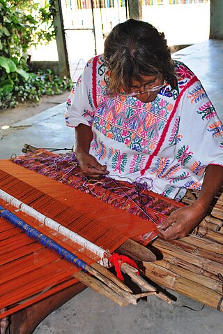
The handcrafts of Guerrero include a number of products which are mostly made by the indigenous communities of the Mexican state of Guerrero. Some, like pottery and basketry, have existed relatively intact since the pre Hispanic period, while others have gone through significant changes in technique and design since the colonial period. Today, much of the production is for sale in the state's major tourism centers, Acapulco, Zihuatanejo and Taxco, which has influence the crafts’ modern evolution. The most important craft traditions include amate bark painting, the lacquerware of Olinalá and nearby communities and the silverwork of Taxdo.

The first federal electoral district of Guerrero(Distrito electoral federal 01 de Guerrero) is one of the 300 electoral districts into which Mexico is divided for elections to the federal Chamber of Deputies and one of eight such districts in the state of Guerrero.
The second federal electoral district of Guerrero is one of the 300 electoral districts into which Mexico is divided for elections to the federal Chamber of Deputies and one of eight such districts in the state of Guerrero.

