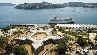
Acapulco de Juárez, commonly called Acapulco, is a city and major seaport in the state of Guerrero on the Pacific Coast of Mexico, 380 kilometres (240 mi) south of Mexico City. Located on a deep, semicircular bay, Acapulco has been a port since the early colonial period of Mexico's history. It is a port of call for shipping and cruise lines running between Panama and San Francisco, California, United States. The city of Acapulco is the largest in the state, far larger than the state capital Chilpancingo. Acapulco is also Mexico's largest beach and balneario resort city. Acapulco de Juárez, Guerrero is the municipal seat of the municipality of Acapulco, Guerrero.

Guerrero, officially the Free and Sovereign State of Guerrero, is one of the 32 states that comprise the 32 Federal Entities of Mexico. It is divided into 81 municipalities. The state has a population of about 3.5 million people. It is located in southwest Mexico and is bordered by the states of Michoacán to the north and west, the State of Mexico and Morelos to the north, Puebla to the northeast and Oaxaca to the east. In addition to the capital city, Chilpancingo and the largest city Acapulco, other cities in Guerrero include Petatlán, Ciudad Altamirano, Taxco, Iguala, Ixtapa, and Zihuatanejo. Today, it is home to a number of indigenous communities, including the Nahuas, Mixtecs, Tlapanecs, Amuzgos, and formerly Cuitlatecs. It is also home to communities of Afro-Mexicans in the Costa Chica region.

Acapulco International Airport, officially Aeropuerto Internacional General Juan N. Álvarez, is an international airport located in Acapulco, Guerrero, Mexico. It serves as a gateway to Acapulco, a popular Mexican tourist destination. The airport also serves charter flights and facilitates various tourism-related activities, flight training, and general aviation. It is named in honor of Juan N. Álvarez, former President of Mexico. The airport is operated by Grupo Aeroportuario Centro Norte (OMA). In 2022, the airport handled 838,991 passengers, and in 2023 it handled 894,012 passengers.
Misantla is a city in the Mexican state of Veracruz, the administrative seat of the municipality (municipio) of the same name. The municipality is bordered by Martínez de la Torre, Colipa and Papantla.
Workers Party of Acapulco was a Mexican Magonist and Socialist political party locally in Acapulco, Mexico. Founded by Juan R. Escudero and existed between 1919 and 1923. POA published Regeneración.

Tlaxiaco is a city, and its surrounding municipality of the same name, in the Mexican state of Oaxaca. It is located in the Tlaxiaco District in the south of the Mixteca Region, with a population of about 17,450.

Ángel Tavira Maldonado was a Mexican composer, musician and violinist of son calentano. He was awarded the Best Actor Award on the 2006 Cannes Film Festival in the Un Certain Regard section for his role in the movie The Violin.
Cutzamala de Pinzón is a city, and the seat of the municipality of Cutzamala de Pinzón, in the Mexican state of Guerrero. As of 2020 the city has a population of 4,717. It is located in the far northwestern part of the state, on the border with Michoacán.
Zacarías Salmerón Daza was a Mexican composer, musician and violinist of son calentano.
Putla Villa de Guerrero or simply Putla, is a town and municipality in the State of Oaxaca, Mexico. It is part of Putla District in the west of the Sierra Sur Region.

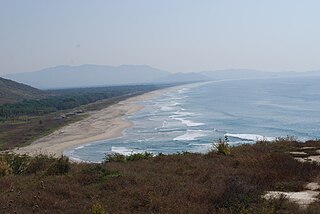
The Costa Chica of Guerrero is an area along the south coast of the state of Guerrero, Mexico, extending from just south of Acapulco to the Oaxaca border. Geographically, it consists of part of the Sierra Madre del Sur, a strip of rolling hills that lowers to coastal plains to the Pacific Ocean. Various rivers here form large estuaries and lagoons that host various species of commercial fish.
Costa Grande of Guerrero is a sociopolitical region located in the Mexican state of Guerrero, along the Pacific Coast. It makes up 325 km (202 mi) of Guerrero's approximately 500 km (311 mi) coastline, extending from the Michoacán border to the Acapulco area, wedged between the Sierra Madre del Sur and the Pacific Ocean. Acapulco is often considered part of the Costa Grande; however, the government of the state classifies the area around the city as a separate region. The Costa Grande roughly correlates to the Cihuatlán province of the Aztec Empire, which was conquered between 1497 and 1504. Before then, much of the area belonged to a dominion under the control of the Cuitlatecs, but efforts by both the Purépecha Empire and Aztec Empire to expand into this area in the 15th century brought this to an end. Before the colonial period, the area had always been sparsely populated with widely dispersed settlements. The arrival of the Aztecs caused many to flee and the later arrival of the Spanish had the same effect. For this reason, there are few archeological remains; however, recent work especially at La Soledad de Maciel has indicated that the cultures here are more important than previously thought. Today, the area economically is heavily dependent on agriculture, livestock, fishing and forestry, with only Zihuatanejo and Ixtapa with significantly developed infrastructure for tourism. The rest of the coast has been developed spottily, despite some government efforts to promote the area.
Federal Highway 95 connects Mexico City to Acapulco, Guerrero. The Autopista del Sol is a tolled alternative, which bypasses several towns of the state of Guerrero, including the city Iguala, and thus reduces transit time between Acapulco from Mexico city from 8 hours to almost 3.5 hours.

Juan R. Escudero is a municipality in the Mexican state of Guerrero. The municipal seat lies at Tierra Colorada. The municipality covers an area of 652.6 km².
Cuajinicuilapa is a municipality in the Mexican state of Guerrero. The municipal seat lies at Cuajinicuilapa. The municipality covers an area of 857.1 km². In 2020, the municipality had a total population of 26,627, up from 25,537 in 2005.
Tehuacalco is an archeological site located near the city of Chilpancingo, Guerrero, Mexico. It was the first archeological site associated with the Yope people to be excavated, in the 2000s. The site is on a hill surrounded by mountains, which were worshipped by the Yope. Four marked the cardinal directions and one, Compuerta, was used to mark solar events such as equinoxes and solstices as the sun rose behind it. Tehuacalco was occupied as a ceremonial site from about 400CE to about 1100CE. The site was opened to the public in 2008.

The Triangle of the Sun is a tourist area in the state of Guerrero that runs through the Sierra Madre del Sur of that state. This tourist area is formed by the cities of Acapulco in the south, the pair of Ixtapa-Zihuatanejo in the north, and Taxco in the center of the state. These cities are those that receive more tourists in Guerrero.

Manuel Añorve Baños is a Mexican politician affiliated with the Institutional Revolutionary Party (PRI). He served as a senator in the 64th and 65th Legislature of the Mexican Congress, representing the state of Guerrero. He also is a two-time federal deputy and two-time former mayor of Acapulco.
Federal Highway 95D is a toll highway connecting Mexico City to Acapulco, Guerrero. Highway 95D is among the most important toll roads in the country, serving as a backbone for traffic out of Mexico City toward Morelos and tourist destinations in Guerrero.

San Nicolás is a municipality in the Mexican state of Guerrero. It is located 165 kilometres (103 mi) southeast of the state capital of Chilpancingo. It is named after its patron saint, Nicholas of Tolentino. Its creation from the municipality of Cuajinicuilapa was approved in 2021 and went into force on 21 May 2022.