
Guanajuato, officially the Free and Sovereign State of Guanajuato, is one of the 32 states that make up the Federal Entities of Mexico. It is divided into 46 municipalities and its capital city is Guanajuato.
Totolapan is a municipality in the north of the Mexican state of Morelos, surrounded by the State of Mexico to the north; to the south with Tlayacapan and Atlatlahucan; to the east and southeast with Atlatlahucan; and to the west with Tlalnepantla.

San Miguel de Allende is the principal city in the municipality of San Miguel de Allende, located in the far eastern part of Guanajuato, Mexico. A part of the Bajío region, the town lies 274 km (170 mi) from Mexico City, 86 km (53 mi) from Querétaro and 97 km (60 mi) from the state capital of Guanajuato. The town's name derives from a 16th-century friar, Juan de San Miguel, and a martyr of Mexican Independence, Ignacio Allende, who was born in a house facing the central plaza. San Miguel de Allende was a critical epicenter during the historic Chichimeca War (1540–1590) when the Chichimeca held back the Spanish Empire during the initial phases of European colonization. Today, an old section of the town is part of a proclaimed World Heritage Site, attracting thousands of tourists and new residents from abroad every year.

Arandas is a municipality of the Altos Sur region of the state of Jalisco in Mexico. Arandas is also the name of the municipality's main township and the center of the municipal government. The city centre is located approximately 86 miles (138 km) east of Guadalajara, the state capital. Arandas is accessible to residents of Guadalajara by the Mexican Federal Highway 80D and Jalisco State Highway 314.
Azángaro is a town in Southern Peru, capital of the province Azángaro in the region of Puno.
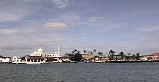
Tlacotalpan is a municipality located in the eastern coastal region of the Mexican state of Veracruz. It covers a total surface area of 646.51 km2 (250 sq mi), accounting for 0.89% of the state total. The municipal seat is the city of Tlacotalpan, Veracruz, a UNESCO World Heritage Site.
Cuitlatec, or Cuitlateco, is an extinct language of Mexico, formerly spoken by an indigenous people known as Cuitlatec.
Chalma is a municipality in the Mexican state of Veracruz.
El Higo is a municipality of the Mexican state of Veracruz. It is located in the state's Huasteca Alta region. The municipal seat is the village of El Higo, Veracruz.

Atoyac de Álvarez is a municipality in the Mexican state of Guerrero. The municipal seat lies at Atoyac de Álvarez. The municipality covers an area of 1,638.4 km2 (632.6 sq mi).

Juárez Hidalgo is a town and one of the 84 municipalities of Hidalgo, in central-eastern Mexico. Created in 1869, its name honours both Benito Juárez and Miguel Hidalgo. The present-day municipal seat was known as Itztapanitla prior to European contact and, in colonial times, as San Guillermo.
Omitlán de Juárez is a town and one of the 84 municipalities of Hidalgo, in central-eastern Mexico. The municipality covers an area of 110.5 km².

Tasquillo is a town and one of the 84 municipalities of Hidalgo, in central-eastern Mexico. it is located km 5 from the Mexican Federal Highway 45 and km 10 from the nearby city of Ixmiquilpan in the central west part of the state of Hidalgo.

La Manzanilla de La Paz is a town and municipality, in Jalisco in central-western Mexico. The municipality covers an area of 134 km². As of 2020, the municipality had a total population of 4,099.
Juchitepec is a municipality in State of Mexico in central Mexico. The municipal seat is the city of Juchitepec de Mariano Rivas. Juchitepec means “Hill of the Flowers” in Nahuatl. The municipality covers an area of 149.56 km2. It has one major community outside the seat called San Matias Cuijingo. The municipality is located at the southwest of the state, and borders the municipalities of Tenango del Aire, Tepetlixpa, Ozumba and Ayapango in the State of Mexico, and with Totolapan and Tlalnepantla in the state of Morelos to the south, and the borough of Milpa Alta in Mexico City to the west. A large part of the population is employed in commerce. Other major economic activities include agriculture and livestock. As of the 2010 census, the municipality had a total population of 23,497 inhabitants.
Santa María Apazco is a town and municipality in Oaxaca in south-western Mexico. It is part of the Nochixtlán District in the southeast of the Mixteca Region.
San Jerónimo Tecuanipan is a town and municipality in the Mexican state of Puebla in south-eastern Mexico. In 2020, the municipality reported a total population of 6,597, an increase of 13.2% from 2010.
San Matías Tlalancaleca is a town and municipality in the Mexican state of Puebla in south-eastern Mexico. The population of San Matias Tlalancaleca was 20,974 inhabitants in 2015.
Sarapiquí is the name of the district number 14 of the canton of Alajuela, that in turn belongs to the province of Alajuela in Costa Rica.
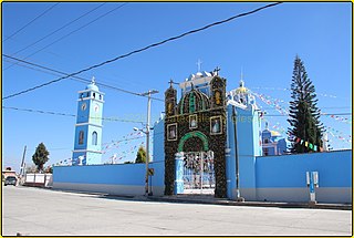
On October 5, 2022, gunmen allegedly associated with the Los Tequileros cartel killed over 20 people, including the town mayor Conrado Mendoza Almeda, in San Miguel Totolapan, Guerrero, Mexico.


