| Tlacoachistlahuaca | |
|---|---|
| Municipal seat and city | |
 Tlacoachistlahuaca Location in Mexico | |
| Coordinates: 18°13′N99°29′W / 18.217°N 99.483°W Coordinates: 18°13′N99°29′W / 18.217°N 99.483°W | |
| Country | |
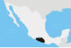
| State | Guerrero |
| Municipality | Tlacoachistlahuaca |
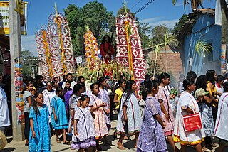
Tlacoachistlahuaca is a city and seat of the municipality of Tlacoachistlahuaca, in the state of Guerrero, south-western Mexico. [1]

Tlacoachistlahuaca is one of the 81 municipalities of Guerrero, in south-western Mexico. The municipal seat lies at Tlacoachistlahuaca. The municipality covers an area of 450.6 km².

Guerrero, officially the Free and Sovereign State of Guerrero, is one of the 31 states which, with the Federal District, comprise the 32 Federal Entities of Mexico. It is divided in 81 municipalities and its capital city is Chilpancingo and its largest city is Acapulco.

Mexico, officially the United Mexican States, is a country in the southern portion of North America. It is bordered to the north by the United States; to the south and west by the Pacific Ocean; to the southeast by Guatemala, Belize, and the Caribbean Sea; and to the east by the Gulf of Mexico. Covering almost 2,000,000 square kilometres (770,000 sq mi), the nation is the fifth largest country in the Americas by total area and the 13th largest independent state in the world. With an estimated population of over 120 million people, the country is the eleventh most populous state and the most populous Spanish-speaking state in the world, while being the second most populous nation in Latin America after Brazil. Mexico is a federation comprising 31 states and Mexico City, a special federal entity that is also the capital city and its most populous city. Other metropolises in the state include Guadalajara, Monterrey, Puebla, Toluca, Tijuana and León.