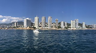
Acapulco de Juárez, commonly called Acapulco, Guerrero, is a city and major seaport in the state of Guerrero on the Pacific Coast of Mexico, 380 kilometres (240 mi) south of Mexico City. Acapulco is located on a deep, semicircular bay and has been a port since the early colonial period of Mexico's history. It is a port of call for shipping and cruise lines running between Panama and San Francisco, California, United States. The city of Acapulco is the largest in the state, far larger than the state capital Chilpancingo. Acapulco is also Mexico's largest beach and balneario resort city. Acapulco de Juárez, Guerrero is the municipal seat of the municipality of Acapulco, Guerrero.

Oaxaca, officially the Free and Sovereign State of Oaxaca, is one of the 32 states that compose the Federative Entities of the United Mexican States. It is divided into 570 municipalities, of which 418 are governed by the system of usos y costumbres with recognized local forms of self-governance. Its capital city is Oaxaca de Juárez.

Guerrero, officially the Free and Sovereign State of Guerrero, is one of the 32 states that comprise the 32 Federal Entities of Mexico. It is divided into 81 municipalities. The state has a population of about 3.5 million people. It is located in southwest Mexico and is bordered by the states of Michoacán to the north and west, the State of Mexico and Morelos to the north, Puebla to the northeast and Oaxaca to the east. In addition to the capital city, Chilpancingo and the largest city Acapulco, other cities in Guerrero include Petatlán, Ciudad Altamirano, Taxco, Iguala, Ixtapa, and Zihuatanejo. Today, it is home to a number of indigenous communities, including the Nahuas, Mixtecs, Tlapanecs, Amuzgos, and formerly Cuitlatecs. It is also home to communities of Afro-Mexicans in the Costa Chica region.
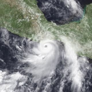
Hurricane Pauline was one of the deadliest Pacific hurricanes to make landfall in Mexico. The sixteenth tropical storm, eighth hurricane, and seventh major hurricane of the 1997 Pacific hurricane season, Pauline developed out of a tropical wave from Africa on September 16, 1997, moving across South America and into the Pacific Ocean. On October 5, the depression intensified into a tropical storm early the next day and by October 7, Pauline had reached hurricane intensity. It initially moved eastward, then turned northwestward and quickly strengthened to reach peak winds of 135 mph (217 km/h). It paralleled the Mexican coastline a short distance offshore before weakening and making landfall near Puerto Ángel, Oaxaca, on October 9, and dissipated the next day.

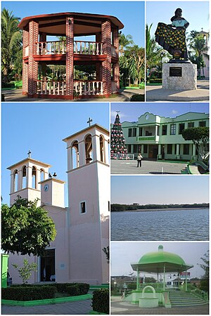
Pinotepa Nacional is a city and seat of the municipality of the same name, in the Mexican state of Oaxaca. It is located in the Jamiltepec District in the west of the Costa Region. The name Pinotepa means "toward the crumbling hill" in Náhuatl.

The Costa Chica of Guerrero is an area along the south coast of the state of Guerrero, Mexico, extending from just south of Acapulco to the Oaxaca border. Geographically, it consists of part of the Sierra Madre del Sur, a strip of rolling hills that lowers to coastal plains to the Pacific Ocean. Various rivers here form large estuaries and lagoons that host various species of commercial fish.
Costa Grande of Guerrero is a sociopolitical region located in the Mexican state of Guerrero, along the Pacific Coast. It makes up 325 km (202 mi) of Guerrero's approximately 500 km (311 mi) coastline, extending from the Michoacán border to the Acapulco area, wedged between the Sierra Madre del Sur and the Pacific Ocean. Acapulco is often considered part of the Costa Grande; however, the government of the state classifies the area around the city as a separate region. The Costa Grande roughly correlates to the Cihuatlán province of the Aztec Empire, which was conquered between 1497 and 1504. Before then, much of the area belonged to a dominion under the control of the Cuitlatecs, but efforts by both the Purépecha Empire and Aztec Empire to expand into this area in the 15th century brought this to an end. Before the colonial period, the area had always been sparsely populated with widely dispersed settlements. The arrival of the Aztecs caused many to flee and the later arrival of the Spanish had the same effect. For this reason, there are few archeological remains; however, recent work especially at La Soledad de Maciel has indicated that the cultures here are more important than previously thought. Today, the area economically is heavily dependent on agriculture, livestock, fishing and forestry, with only Zihuatanejo and Ixtapa with significantly developed infrastructure for tourism. The rest of the coast has been developed spottily, despite some government efforts to promote the area.
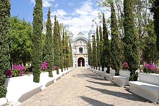
Ocotlán de Morelos is a town and municipality in the state of Oaxaca, about 35 km south of the center of the city of Oaxaca along Highway 175. It is part of the Ocotlán District in the south of the Valles Centrales Region. The area was a significant population center at the time of the Spanish Conquest, and for that reason an important Dominican monastery was established here in the 16th century. The complex still exists, with the church still being used for worship and the cloister area used as a museum. While mostly quiet, the city is an important distribution and transportation center for the south of the Central Valleys region of Oaxaca, a function which is expected to be reinforced with the opening of new highway being built to connect the city of Oaxaca with the Pacific coast. The city is known for artist Rodolfo Morales, who painted aspects of his hometown in his works and sponsored projects to save and restore historic monuments here. For generations the municipality has been known for its crafts, with the ceramics making Aguilar family producing some of the best known craftsmen.
Santiago Jamiltepec is a town, and the seat of surrounding municipality of the same name, in the Mexican state of Oaxaca. It is located in the Jamiltepec District in the west of the Costa Chica Region, 30 km east of Pinotepa Nacional on Federal Highway 200, and 460 km southwest of state capital Oaxaca de Juárez.
Federal Highway 95 connects Mexico City to Acapulco, Guerrero. The Autopista del Sol is a tolled alternative, which bypasses several towns of the state of Guerrero, including the city Iguala, and thus reduces transit time between Acapulco from Mexico city from 8 hours to almost 3.5 hours.
Cuajinicuilapa is a municipality in the Mexican state of Guerrero. The municipal seat lies at Cuajinicuilapa. The municipality covers an area of 857.1 km². In 2020, the municipality had a total population of 26,627, up from 25,537 in 2005.
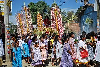
Xochistlahuaca is a town in Xochistlahuaca Municipality located in the southeast corner of the Mexican state of Guerrero. It is part of this state's Costa Chica region and while near the Pacific Ocean, most of the territory is mountainous. The population is dominated by the indigenous Amuzgo ethnicity, whose women are noted for their traditional hand woven garments, especially the huipil, which is made both for home use and for sale outside the area.

Tropical Storm Carlos was the first of five tropical cyclones to make landfall during the 2003 Pacific hurricane season. It formed on June 26 from a tropical wave to the south of Mexico. It quickly strengthened as it approached the coast, and early on June 27 Carlos moved ashore in Oaxaca with winds of 65 mph (105 km/h). The storm rapidly deteriorated to a remnant low, which persisted until dissipating on June 29. Carlos brought heavy rainfall to portions of southern Mexico, peaking at 337 mm (13.3 in) in two locations in Guerrero. Throughout its path, the storm damaged about 30,000 houses, with a monetary damage total of 86.7 million pesos. At least nine people were killed throughout the country, seven due to mudslides and two from river flooding; there was also a report of two missing fishermen.

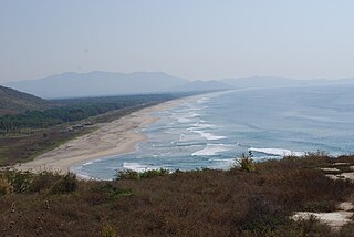
The Costa Region or Costa Chica lies on the Pacific coast of the state of Oaxaca, Mexico, south of the more mountainous Sierra Sur inland from the coast. It includes the districts of Jamiltepec, Juquila and Pochutla.
Hurricane Dolores was regarded as the worst hurricane to strike Acapulco since 1938. Developing on June 13, 1974, the system rapidly organized into a tropical storm the next day off the southern coast of Mexico. Over the following day, Dolores developed an eye-like feature and attained hurricane status. With peak winds of 80 mph (130 km/h), the storm made landfall near Acapulco. Once onshore, Dolores rapidly dissipated and was last noted on June 17.
The 2012 Guerrero–Oaxaca earthquake struck southern Mexico with a moment magnitude of 7.4 at on Tuesday, 20 March. Its epicenter was near Ometepec, in the border between the states of Guerrero and Oaxaca. With a shallow focus of 20 km, the earthquake caused strong shaking over a large area along the Oaxaca–Guerrero border and the adjacent Pacific coastline. Significant tremors were felt in areas up to several hundred kilometers away, including Mexico City and also in Guatemala. Two people were killed and over 30,000 houses were damaged or destroyed.
The Amuzgos are an indigenous people of Mexico. They primarily live in a region along the Guerrero/Oaxaca border, chiefly in and around four municipalities: Xochistlahuaca, Tlacoachistlahuaca and Ometepec in Guerrero, and San Pedro Amuzgos in Oaxaca. Their languages are similar to those of the Mixtec, and their territories overlap. They once dominated a larger area, from La Montaña down to the Costa Chica of Guerrero and Oaxaca, but Mixtec expansion, rule and later Spanish colonization has pushed them into the more inaccessible mountain regions and away from the coast. The Amuzgos maintain much of their language and dress and are known for their textiles, handwoven on backstrap looms with very intricate two-dimensional designs. The Amuzgo area is very poor with an economy mostly dependent on subsistence agriculture and handcraft production.

The Mexican South Pacific Coast mangroves ecoregion covers the mangrove sites along the coast of the Pacific Ocean coast of Mexico, across the states of Michoacán, Guerrero, and Oaxaca. These mangrove forests are mostly around lagoons, typically those fed by rivers from the interior in the Sierra Madre del Sur Mountains. The ecoregion is small: collectively, it covers only 1,295 km2.
A moment magnitude Mw 7.0 or 7.1 earthquake occurred near the city of Acapulco in the Mexican state of Guerrero at on 7 September with an estimated intensity of VIII (Severe) on the MMI scale. The earthquake killed 13 people and injured at least 23 others. At least 1.6 million people in Mexico were affected by the earthquake which resulted in localized severe damage. The earthquake occurred on the anniversary of the 2017 Chiapas earthquake which measured Mw 8.2. It was also the largest earthquake in Mexico since the 2020 Oaxaca earthquake.

Tropical Storm Lester was a short-lived tropical cyclone that caused severe rainfall and flash flooding in southern Mexico in September 2022. The thirteenth named storm of the 2022 Pacific hurricane season, Lester developed from an area of disturbed weather that formed offshore the Pacific Coast of Mexico on September 13. The disturbance spawned an area of low pressure two days later, which quickly organized into a tropical depression at 18:00 UTC on September 15. Moving slowly northwestward, the depression strengthened into Tropical Storm Lester the following morning. Despite being located over very warm sea surface temperatures and in a moist environment, Lester was unable to intensify further and remained a minimal tropical storm as it slowly approached the coast of Mexico, due to moderately strong wind shear. Lester made landfall near Punta Maldonado in extreme southwestern Guerrero as a tropical depression around 12:00 UTC on September 17. The cyclone quickly dissipated over the rough terrain of Mexico later that day.