
The State of Mexico, officially just Mexico, is one of the 32 federal entities of the United Mexican States. Commonly known as Edomex to distinguish it from the name of the whole country, it is the most populous, as well as the most densely populated, state in the country.

Zihuatanejo de Azueta is a municipality in the Mexican state of Guerrero. It includes the major resort communities of Zihuatanejo and Ixtapa in addition to numerous other towns. In 2010 it had a population of 118,211 inhabitants. It has an area of 1468 km². Its municipal seat is the city of Zihuatanejo. Its municipal president for the 2005-08 period was Silvano Blanco Deaquino.

Práxedis Gilberto Guerrero is the municipal seat of the municipality of Práxedis G. Guerrero in the northern Mexican state of Chihuahua.

Villaflores is a municipality in the southern Mexican state of Chiapas, and the name of its largest settlement and seat of the municipal government. Situated in the Sierra Madre de Chiapas range, the municipality has an area of approximately 1232 km2 at an average elevation of 540m above mean sea level.
The Instituto Nacional para el Federalismo y el Desarrollo Municipal is a decentralised agency of the Mexican federal government. It has responsibility for promoting the ideals of federalism between the several levels of government in Mexico, by acting to coordinate and implement policies, programmes and services that are designed to strengthen inter-governmental relations between the federal and "subsidiary" levels of governance at the state and municipal levels.
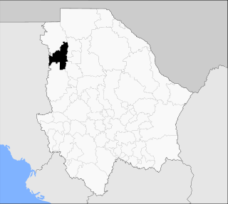
Casas Grandes Municipality is located in the northern Mexican state of Chihuahua. The municipal seat is the town of Casas Grandes, Chihuahua.
Vicente Guerrero is a municipality in the Mexican state of Durango. The municipal seat lies at Vicente Guerrero. The municipality covers an area of 402.24 km² and is composed of 19 localities.
Alcozauca de Guerrero is a municipality in the Mexican state of Guerrero. The municipal seat lies at Alcozauca de Guerrero. The municipality covers an area of 55,160 hectares.

Iliatenco is a municipality in the Mexican state of Guerrero. The municipal seat lies at Iliatenco. In 2005, the municipality had a total population of 10,039 and is the newest of municipalities in Guerrero, formed in 2005
Leonardo Bravo is a municipality in the Mexican state of Guerrero. The municipal seat lies at Chichihualco. The municipality covers an area of 852 km².

Tixtla de Guerrero is a municipality in the Mexican state of Guerrero. The municipal seat lies at Tixtla de Guerrero. The municipality covers an area of 290 square kilometres (110 sq mi).
Chilpancingo de los Bravo is a municipality in the Mexican state of Guerrero. The municipal seat is Chilpancingo de los Bravo.
Mártir de Cuilapán is a municipality in the Mexican state of Guerrero. The municipal seat lies at Apango. The municipality covers an area of 499.8 km2.
Teloloapan is a municipality in the Mexican state of Guerrero. The municipal seat is the city of Teloloapan. It is enclosed in the heart of the Southern Sierra Madre in the northern part of said region. It has the geographical coordinates 18°22′04″N 99°52′26″O and an altitude of 1,860 metres above sea level.
Xochistlahuaca Municipality is a municipality in the Mexican state of Guerrero. The municipal seat lies at Xochistlahuaca. The municipality covers an area of 321.1 km².

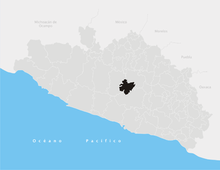
Zitlala is a municipality in the Mexican state of Guerrero.
Tekom Municipality is a municipality in the Mexican state of Yucatán. Tekom is also the name of the municipality's largest settlement and seat of the municipal government. In the XII national census conducted by INEGI in 2000, Tekom municipality recorded a population of 2,660 inhabitants. In the intermediate census count undertaken by INEGI in 2005, the total municipal population was recorded as 2,933 inhabitants, 2,413 of whom spoke one of the recognised indigenous languages of Mexico.

Tancanhuitz is a town and one of the 58 municipalities of the state of San Luis Potosí in central Mexico. It is located in the southeastern part of the state, approximately 330 km (210 mi) from the city of San Luis Potosí. The municipality covers an area of 134.05 km².
María Fermina Rivera was an insurgent in the Mexican War of Independence where she was a part of Vicente Guerrero's small force. Rivera was born in Tlaltizapán, in what today is the state of Morelos. In 1821, Rivera accompanied her husband into combat on the front line with Guerrero’s forces and continued fighting for independence throughout the last years of the war.

