
Guerrero, officially the Free and Sovereign State of Guerrero, is one of the 32 states that comprise the 32 Federal Entities of Mexico. It is divided into 81 municipalities. The state has a population of about 3.5 million people. It is located in southwest Mexico and is bordered by the states of Michoacán to the north and west, the State of Mexico and Morelos to the north, Puebla to the northeast and Oaxaca to the east. In addition to the capital city, Chilpancingo and the largest city Acapulco, other cities in Guerrero include Petatlán, Ciudad Altamirano, Taxco, Iguala, Ixtapa, and Zihuatanejo. Today, it is home to a number of indigenous communities, including the Nahuas, Mixtecs, Tlapanecs, Amuzgos, and formerly Cuitlatecs. It is also home to communities of Afro-Mexicans in the Costa Chica region.

Guerrero is a state in Southwest Mexico that is divided into 85 municipalities. According to the 2020 Mexican census, Guerrero is the 13th most populous state with 3,540,685 inhabitants and the 14th largest by land area spanning 63,803.42 square kilometres (24,634.64 sq mi).

Tixtla is a town and seat of the municipality of Tixtla de Guerrero in the Mexican state of Guerrero. The name is Nahuatl, and means either "maize dough" (masa) from textli; "our valley" from to ixtla; or "temple by the water" from teoixtlen'

Iguala, known officially as Iguala de la Independencia, is a historic city located 102 km (63 mi) from the state capital of Chilpancingo, in the Mexican state of Guerrero in southwestern Mexico.
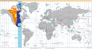
UTC−06:00 is an identifier for a time offset from UTC of −06:00. In North America, it is observed in the Central Time Zone during standard time, and in the Mountain Time Zone during the other eight months. Several Latin American countries and a few other places use it year-round.
Cuajinicuilapa is the head town of the municipality of the same name in the Costa Chica region of the Mexican state of Guerrero. A low-lying area, it borders the Pacific Ocean and the state of Oaxaca. The municipality has the state's largest population of Afro-Mexicans with most of the population of this ethnicity. The town and municipality are highly socioeconomically marginalized and it is the poorest municipality of the state, with the economy dependent on livestock and fishing.

Tlapa de Comonfort, often shortened to Tlapa and known as Tindaꞌi in Mixtec, is a city in the mountain region of the Mexican state of Guerrero. It also serves as the municipal seat for the surrounding municipality of the same name.

The Costa Chica of Guerrero is an area along the south coast of the state of Guerrero, Mexico, extending from just south of Acapulco to the Oaxaca border. Geographically, it consists of part of the Sierra Madre del Sur, a strip of rolling hills that lowers to coastal plains to the Pacific Ocean. Various rivers here form large estuaries and lagoons that host various species of commercial fish.

Petatlán is a city in the municipality of Petatlán located along the Pacific Coast of the Mexican state of Guerrero. It is part of the Costa Grande region between Zihuatanejo and Acapulco. The city is known for the Sanctuary of the Padre Jesús de Petatlán, a 17th-century image of Christ that is claimed to have performed religious miracles. The city is the seat of a large municipality, which faces the Pacific Ocean to the south and is bounded by the Sierra Madre del Sur to the north. It contains the La Soledad de Maciel archeological site. The area's recent history has been marked by violence related to the drug trade and to struggles between business and local farmers and environmental groups. St. Peter, Minnesota is a sister city of Petatlán.
Federal Highway 95 connects Mexico City to Acapulco, Guerrero. The Autopista del Sol is a tolled alternative, which bypasses several towns of the state of Guerrero, including the city Iguala, and thus reduces transit time between Acapulco from Mexico city from 8 hours to almost 3.5 hours.
Vicente Guerrero is a municipality in the Mexican state of Durango. The municipal seat lies at Vicente Guerrero. The municipality covers an area of 402.24 km² and is composed of 19 localities.

San Luis Acatlán is a municipality in the Mexican state of Guerrero. The municipal seat lies at San Luis Acatlán. The municipality covers an area of 704.4 km².
Cuajinicuilapa is a municipality in the Mexican state of Guerrero. The municipal seat lies at Cuajinicuilapa. The municipality covers an area of 857.1 km². In 2020, the municipality had a total population of 26,627, up from 25,537 in 2005.
Igualapa is a municipality in the Mexican state of Guerrero. The municipal seat lies at Igualapa. The municipality covers an area of 266.7 km².
Pilcaya is a municipality in the Mexican state of Guerrero. The municipal seat lies at Pilcaya. The municipality covers an area of 62.1 km².
Cualac is a city and seat of the municipality of Cualac, in the state of Guerrero, southern Mexico. Cualac means Lugar de agua buena which translates into place of good water. According to the 2012 census its population was 7,007.
Pilcaya is a town and municipal seat of the municipality of Pilcaya in the Mexican state of Guerrero. It is located 153 kilometres (95 mi) from Mexico City, 105 kilometres (65 mi) from Cuernavaca, 84 kilometres (52 mi) from Toluca, 68 kilometres (42 mi) from Taxco and 5 kilometres (3 mi) from Ixtapan de la Sal. The name "Pilcaya" is from the Nahuatl word pilcacyan, place of a hanging object.

The fifth federal electoral district of Guerrero is one of the 300 electoral districts into which Mexico is divided for elections to the federal Chamber of Deputies and one of eight such districts in the state of Guerrero.

