
Guerrero, officially the Free and Sovereign State of Guerrero, is one of the 32 states that comprise the 32 Federal Entities of Mexico. It is divided into 81 municipalities. The state has a population of about 3.5 million people. It is located in southwest Mexico and is bordered by the states of Michoacán to the north and west, the State of Mexico and Morelos to the north, Puebla to the northeast and Oaxaca to the east. In addition to the capital city, Chilpancingo and the largest city Acapulco, other cities in Guerrero include Petatlán, Ciudad Altamirano, Taxco, Iguala, Ixtapa, and Zihuatanejo. Today, it is home to a number of indigenous communities, including the Nahuas, Mixtecs, Tlapanecs, Amuzgos, and formerly Cuitlatecs. It is also home to communities of Afro-Mexicans in the Costa Chica region.

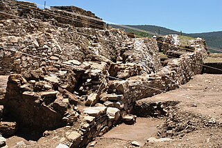
Teopantecuanitlan is an archaeological site in the Mexican state of Guerrero that represents an unexpectedly early development of complex society for the region. The site dates to the Early to Middle Formative Periods, with the archaeological evidence indicating that some kind of connection existed between Teopantecuanitlan and the Olmec heartland of the Gulf Coast. Prior to the discovery of Teopantecuanitlan in the early 1980s, little was known about the region's sociocultural development and organization during the Formative period.
Copalillo is a municipality in the Mexican state of Guerrero. The municipal seat lies at Copalillo. The municipality covers an area of 898.6 km².
Atenango del Río is a city in the southern Mexican state of Guerrero. It serves as the seat of the surrounding municipality of Atenango del Río.

Cuetlajuchitlán is a Mesoamerican archaeological site located 3 kilometers southeast of Paso Morelos, in the northeast of the Mexican state of Guerrero.
Ixcateopan is an archaeological site located in the town and municipality of Ixcateopan de Cuauhtémoc, 36 kilometers from Taxco, in the isolated and rugged mountains of the northern part of the Mexican state of Guerrero.
The Guerrero Nahuatl language is a Nahuan language spoken by about 125,000 people in Mexico.

Manuel Jiménez Ramírez was a Mexican carver, sculptor and painter credited as the originator of the Oaxacan version of “alebrijes,” animal creatures carved in wood and painted in strong contrasting colours with intricate designs. He was a charismatic and philosophical person, who believed he was the reincarnation of an artist. He began making animal figures of clay when he was a child but changed to wood carving later, creating human figures, nativity scenes, masks and more as well as the alebrijes. His work can be found in public and private collections in various parts of the world, especially in the United States.

Gumercindo España Olivares was a Mexican artisan who specialized in traditional toys hand carved from wood. He was from a family of toymakers, beginning with his grandfather, which started in clay but switched to wood. In addition to making traditional toys, the artisan also experimented with new designs, such as those related to the history of Guanajuato. His efforts have won him various awards.
Exothea is a genus of flowering plants belonging to the family Sapindaceae.

The second federal electoral district of Guerrero is one of the 300 electoral districts into which Mexico is divided for elections to the federal Chamber of Deputies and one of eight such districts in the state of Guerrero.
The fourth federal electoral district of Guerrero is one of the 300 electoral districts into which Mexico is divided for elections to the federal Chamber of Deputies and one of eight such districts in the state of Guerrero.
The sixth federal electoral district of Guerrero is one of the 300 electoral districts into which Mexico is divided for elections to the federal Chamber of Deputies and one of eight such districts in the state of Guerrero.

