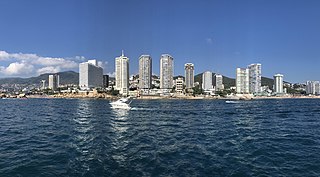
Acapulco de Juárez, commonly called Acapulco, is a city and major seaport in the state of Guerrero on the Pacific Coast of Mexico, 380 kilometres (240 mi) south of Mexico City. Acapulco is located on a deep, semicircular bay and has been a port since the early colonial period of Mexico's history. It is a port of call for shipping and cruise lines running between Panama and San Francisco, California, United States. The city of Acapulco is the largest in the state, far larger than the state capital Chilpancingo. Acapulco is also Mexico's largest beach and balneario resort city. Acapulco de Juárez is the municipal seat of the municipality of Acapulco.

Guerrero, officially the Free and Sovereign State of Guerrero, is one of the 32 states that comprise the 32 Federal Entities of Mexico in Mexico. It is divided in 81 municipalities. The state has a population of about 3.5 million people. It is located in southwest Mexico and is bordered by the states of Michoacán to the north and west, the State of Mexico and Morelos to the north, Puebla to the northeast and Oaxaca to the east. In addition to the capital city, Chilpancingo and the largest city Acapulco, other cities in Guerrero include Petatlán, Ciudad Altamirano, Taxco, Iguala, Ixtapa, and Zihuatanejo. Today, it is home to a number of indigenous communities, including the Nahuas, Mixtecs, Tlapanecs, Amuzgos, and formerly Cuitlatecs. It is also home to communities of Afro-Mexicans in the Costa Chica region.

Taxco de Alarcón is a small city and administrative center of Taxco de Alarcón Municipality located in the Mexican state of Guerrero. Taxco is located in the north-central part of the state, 36 kilometres from the city of Iguala, 135 kilometres from the state capital of Chilpancingo and 170 kilometres southwest of Mexico City.

Tixtla is a town and seat of the Tixtla de Guerrero Municipality in the Mexican state of Guerrero. The name is Nahuatl, and means either "maize dough" (masa) from textli; "our valley" from to ixtla; or "temple by the water" from teoixtlen'

Iguala, known officially as Iguala de la Independencia, is a historic city located 102 km (63 mi) from the state capital of Chilpancingo, in the Mexican state of Guerrero in southwestern Mexico.
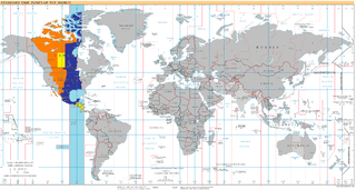
UTC−06:00 is an identifier for a time offset from UTC of −06:00. In North America, it is observed in the Central Time Zone during standard time, and in the Mountain Time Zone during the other eight months. Several Latin American countries and a few other places use it year-round.
Cuajinicuilapa is the head town of the municipality of the same name in the Costa Chica region of the Mexican state of Guerrero. A low-lying area, it borders the Pacific Ocean and the state of Oaxaca. The municipality has the state's largest population of Afro-Mexicans with most of the population of this ethnicity. The town and municipality are highly socioeconomically marginalized and it is the poorest municipality of the state, with the economy dependent on livestock and fishing.
Vicente Guerrero is a small town and seat of the Vicente Guerrero Municipality in the Mexican state of Durango. As of 2010, the city of Vicente Guerrero had a population of 15,982.

The Costa Chica of Guerrero is an area along the south coast of the state of Guerrero, Mexico, extending from just south of Acapulco to the Oaxaca border. Geographically, it consists of part of the Sierra Madre del Sur, a strip of rolling hills that lowers to coastal plains to the Pacific Ocean. Various rivers here form large estuaries and lagoons that host various species of commercial fish.
Federal Highway 95 connects Mexico City to Acapulco, Guerrero. The Autopista del Sol is a tolled alternative, which bypasses several towns of the state of Guerrero, including the city Iguala, and thus reduces transit time between Acapulco from Mexico city from 8 hours to almost 3.5 hours.
Vicente Guerrero is one of the 39 municipalities of Durango, in north-western Mexico. The municipal seat lies at Vicente Guerrero. The municipality covers an area of 402.24 km² and is composed of 19 localities.
Cuajinicuilapa is one of the 81 municipalities of Guerrero, in southern Mexico. The municipal seat lies at Cuajinicuilapa. The municipality covers an area of 857.1 km². In 2020, the municipality had a total population of 26,627, up from 25,537 in 2005.
Cualac is one of the 81 municipalities of Guerrero, in south-western Mexico. The municipal seat lies at Cualac. The municipality covers an area of 196.8 km².
Pilcaya is one of the 81 municipalities of Guerrero, in south-western Mexico. The municipal seat lies at Pilcaya. The municipality covers an area of 62.1 km².
Pilcaya is a town and municipal seat of the Municipality of Pilcaya in the state of Guerrero, Mexico, located 153 kilometres (95 mi) from Mexico City, 105 kilometres (65 mi) from Cuernavaca, 84 kilometres (52 mi) from Toluca, 68 kilometres (42 mi) from Taxco and 5 kilometres (3 mi) from Ixtapan de la Sal. The name "Pilcaya" is from the Nahuatl word pilcacyan, place of a hanging object.
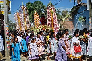
Xochistlahuaca is a town in Xochistlahuaca Municipality located in the southeast corner of the Mexican state of Guerrero. It is part of this state's Costa Chica region and while near the Pacific Ocean, most of the territory is mountainous. The population is dominated by the indigenous Amuzgo ethnicity, whose women are noted for their traditional hand woven garments, especially the huipil, which is made both for home use and for sale outside the area.
The Guerrero Nahuatl language is a Nahuan language spoken by about 125,000 people in Mexico.
The Conglomerado Cualac is a geologic formation in Mexico. First described by Guzmán in 1959, under the name Cuarcita Cualac. Later, Erben (1956) gave it their actual name. It consist of thick beds of a hard, white and sometimes yellowish conglomerate with a cuarcitic matrix. This conglomerate compounds almost exclusively of milky quartz pebbles between .5 and 5 centimeters of diameter. It also presents, in less quantity, pebbles of schist, gneiss, and tuff. Its thickness varies between 30 and more than 200 meters. It preserves fossils dating back to the Jurassic period.
Chiaucingo is a city in the Cualac municipality of the state of Guerrero in Mexico. With a population of 1,331 inhabitants, it is the second largest populated settlement in Cualac. In Chiaucingo, 53.76% of adults speak an indigenous language.

