Zinacantepec

Last updated

Zinacantepec
Municipality
PlazaZinacantepec.JPG
Main Plaza of Zinacantepec
Glifo Zinacantepec.png
Mexico States blank map.svg
Red pog.svg
Zinacantepec
Location in Mexico
Coordinates: 19°17′00″N99°44′00″W / 19.28333°N 99.73333°W / 19.28333; -99.73333
CountryFlag of Mexico.svg  Mexico
State State of Mexico
Municipal SeatSan Miguel Zinacantepec
Municipality Created1826
Government
  Municipal President
PRI logo (Mexico).svg
Manuel Vilchis Viveros (2022-2024)
Area
  Municipality308.68 km2 (119.18 sq mi)
Elevation
(of seat)
2,740 m (8,990 ft)
Population
 (2005) Municipality
  Municipality136,167
  Seat
46,569
Time zone UTC-6 (Central (US Central))
  Summer (DST) UTC-5 (Central)
Postal code (of seat)
51350
Area code 722
Website(in Spanish) /Official site

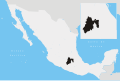
Zinacantepec is a municipality located just west of the city of Toluca in Mexico State, Mexico. [1] The municipal seat is the town of San Miguel Zinacantepec. Zinacantepec is Nahuatl for "bat mountain" and its Aztec glyph is a bat on a mountain. [1] It is named after a small mountain which contained two caves which used to be filled with thousands of bats. [2]

Contents

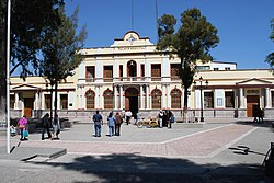
In the 18th century, the residents of this mountain moved to settle alongside the Franciscan monastery established here in the 16th century. [2] This monastery is the best preserved of a network of missionaries established in the Toluca Valley in the mid 16th century. Today, the complex functions as the parish church, with the cloister dedicated as the colonial era museum of the state of Mexico. [3]

History

The history of the town and municipality begins about 1500 years ago at an elevation now named "Cerro de Murciélago" or Bat Mountain. The hill contained two caves that used to be filled with thousands of bats. The presence of these animals was considered a sign of fertility. The hill remained populated until the 18th century, when a plague pushed the population toward the Franciscan monastery, which functioned as a hospital. [2] A deity named Zinacan was associated with the mountain. Shortly after the Spanish Conquest, this deity would be believed to be an incarnation of the Devil. [4] Today, the bat population of the area is limited to a few caves in the Nevado de Toluca National Park. [2] The mountain is mined for gravel and alongside it is the Hacienda de Santa Cruz de los Patos, which is now part of the Mexiquense College, as a research center and library. [4]

The earliest known ethnicity in the area is the Otomi, who still are present, especially in smaller communities in the municipality such as San Luis Mextepec and Acahulaco. In the south of the municipality, there are Matlatzincas; however, there are very few. The area was conquered by the Aztecs in the latter 15th century by Axayacatl. Zinacantepec was then ruled from Tlacopan as a tributary province. [1]

Former monastery ExMonasteryZinacantepec.JPG
Former monastery

During the Spanish conquest of the Aztec Empire, the Otomis sided with the Spanish and the Matlazincas against Aztecs. Gonzalo de Sandoval came to the Toluca Valley with 18 cavalry and 100 infantry. They were joined by 60,000 Otomi and conquered the Matlatzincas. The area around what is now the city of Toluca, including Zinacantepec, came under the rule of Hernán Cortés administrated by his cousin Juan Gutiérrez Altamirano  [ es ] in what would become the County of Santiago de Calimaya. The west part of the valley became part of the encomendero of Juan de Sámano. This same family founded the Hacienda de la Gavia which owned much of the arable land in the municipality. [1]

While no battles were fought here during the Mexican War of Independence, many here joined the army of Miguel Hidalgo y Costilla against the colonial government, with many fighting at the Battle of Monte de las Cruces. After the war, Zinacantepec became a municipality in 1826. [1]

During the Reform War, vandalism and general lawlessness gripped the municipality as well as neighboring Toluca. This was finally put to an end by Felipe Berriozabal in the 1860s. During the Mexican Revolution, Zinacantepec was taken in 1912 by General José Limón and Alberto Sámano in support of Francisco I. Madero. The Zapatistas camped in some of the smaller communities of the municipalities, confronting federal forces and sacking homes. [1]

The 2000s to the present are marked by political and economic problems for the municipality. Starting in 2005, the municipality has had serious financial difficulties, mostly due to its debt. These financial problems have caused inadequacies in the drainage, garbage collection and health services. [5] In 2007, residents protested the lack of adequate garbage collection by bringing their garbage to the municipal palace and threatened to leave it there. They claim that in some areas, garbage had not been collected for months, requiring children to wear masks on their way to school. [6] In 2008, councilman Leonardo Bravo Hernandez was sentenced to 18 months for the misappropriation of 100 million pesos during the city council session of 2003–2006. [7] José Consuelo González Xingú, a municipal delegate was shot and killed in January 2010 in San Antonio Acajhualco, a community in the municipality. Gonzalez Xingú had presented a complaint to the Mexico State Commission of Human Rights for acts of intimidation and abuse among the municipal police force. Prior to this, Gonzalez Xingu had also made a formal complaint to the state about the municipal president for nepotism, which was ratified. The municipal president denies involvement. [8] The municipal president, Gustavo Vargas Cruz, has been under investigation for the murder of Jesus Consuelo Xingú. One of the reported gunmen has been apprehended. [9]

Until 2008, Zinacantepec was the only municipality with roads with no right-of-way markers. In that year, the direction and signaling of all the roads was reworked in a systematic way. [10]

Zinacantepec will be the western terminus for the Toluca–Mexico City commuter rail when service commences in 2018. [11]

Town

Municipal palace in town center ZinMuniPal2.JPG
Municipal palace in town center

Although just west of the city of Toluca, Zinacantepec remains mostly rural, preserving much of its traditions and customs from over 300 years ago. [12] Major religious festivals include one in honor of the Virgin of Los Dolores (also called Del Rayo) from May 21 to 23 and one for the patron of the town, the Archangel Michael on December 3. [1] One legend associated with the Virgin was that the image was left at the local monastery by a woman who had been cured of the plague. In 1762, a bolt of lightning struck and destroyed the church tower, but the Virgin, who was inside, was unharmed. [4]

Nave of the parish of San Miguel NaveZinacan.JPG
Nave of the parish of San Miguel

The town’s main church, the Parish of San Miguel, was the monastery church until the monastery church was closed during the Reform War. The church remained open but with non-monastic priests. [1] The structure dates from the 17th century, and has typical features for constructions from that time such as a cruciform plan, a central dome and an ornate two tier bell tower. Since it was Franciscan, the facade is a sober Baroque with minimal ornamentation. Inside, on the south wall is a stone pulpit decorated with carved scales. It also contains an unusual ceramic baptismal font which dates from the early colonial period. The rest of the church is fairly modern but colonial paintings and church furnishings from earlier periods can be found in the sacristy. [3]

Market day is Sunday when the street fill with vendors and local specialties such as red and green mole, local produce, tamales and small tacos made with corn tortillas about 6 cm in diameter. Local drinks include pulque and fruit liquors. [1] [4]

Universidad Politécnica Del Valle de Toluca has its secondary campus in the town. It offers programs of study in engineering and business. [13]

Monastery complex

View of cloister area with bell tower CloisterBellTower.JPG
View of cloister area with bell tower

The Toluca Valley was evangelized by the Franciscans starting from the 1520s. During the 1550s and 1560s, a network of missions was built spreading out from Toluca, where missionaries would begin by studying the languages and customs of the native peoples of the valley. Of these missions, the monastery at Zinacantepec is the best preserved. [3] The mission with its open chapel was begun in 1550, with the rest of the monastery built between 1560 and 1570. [1] [3] The modern town of Zinacantepec was built around it when the local populace abandoned the nearby hill and settled around the monastery in the 18th century. [2] The monastery remained in operation from the early colonial period until the Reform War when it was closed by the government. It is said that it was occupied by Zapatista forces during the Mexican Revolution. Later in the 20th century, part of it was used to house priests who ran the still functioning Parish of San Miguel. It was declared a national monument in 1933. [1] In 1976, the State of Mexico took over the cloister portion of the complex (leaving the church open for worship) and began to renovate it with the purpose of founding a museum, along with the Fondo Nacional para Actividades Sociales (FONAPAS). [1] The museum was opened in 1980 as the Museo del Virrenato del Valle de Toluca (Museum of Viceregal Art of the Valley of Toluca. [14] The collection is housed in the rooms of the cloister with the open chapel area serving as the main entrance. [1] The oldest portion of the complex is the open chapel, which dates from the time when the structure began as a small mission. The chapel is integrated into a porteria (a porch like entrance or arcade) in the front of the building, which was added in the 1560s. The altarpiece of the chapel is recessed into the back wall which has a pediment and contains ten panels. The central figure is of the Archangel Michael, the original patron saint of the mission. Above him is a female saint, possibly Saint Clare, with archangels and luminaries of the Church on the surrounding panels. God, the Father looks down from the pediment with the Four Evangelists at the base. [3]

Mural of the genealogy of the Franciscan Order MuralGenFranciscanZina.JPG
Mural of the genealogy of the Franciscan Order

In a small room on the south end of the porteria is the original mission baptistery. Here is the first baptismal font, which is a huge monolithic basin cut from gray volcanic stone. The outside is carved with both Christian and indigenous symbols. Carved medallions illustrate episodes in Christ’s life, and there is a relief of the Archangel Michael casting Lucifer from heaven. The indigenous symbolism includes Aztec speech markers and pre-Hispanic water imagery. [3] Encircling the cord rim is a Spanish and Nahuatl inscription which says, “This baptismal font and the room in which it is found was mandated by the venerable guardian Fray Martin de Aguirre in the village of Zinacantepec in the year 1581.” [4] This font is one of the most important pieces at the museum. [15]

Above the low main door into the cloister, there is a mural from the 16th century called the “Tree of Life” which illustrates a genealogical tree of the Franciscan Order, growing from the chest of Francis of Assisi. Unlike many of the other frescos, this one contains various colors, including red and green accents, flesh tones and framed by bands of color. [3] This murals as well as the font and the panels of the altarpieces were designed for the early evangelical efforts of the monastery. [1]

Inside the main entrance is a vestibule which leads to the main courtyard of the cloister. This area is plainer than the porteria, with only black and white 16th-century frescos adorning the walls and some gray gargoyles on the upper parts of the columns. Many of the frescos and gargoyles are now fragmentary. The cloister has two floors and courtyard surrounded by 20 arches supported by Tuscan columns. The ceilings are made from large wood beams and the floors are paved in local stone. [3] [4] On the north and south sides of the upper cloister there are two sundials. One is meant to be used in the summer and the other in winter. [1]

Antecoro or "Hall of the Viceroys" AntecoroZina.JPG
Antecoro or "Hall of the Viceroys"

The cloister complex is now the Museo Virreinal de Zinacantepec (Viceregal Museum of Zinacantepec). [15] It has twenty exhibition halls, with more than 275 works of art over the three centuries of the colonial period in Mexico. The collection also include more ordinary items such as cooking utensils, weapons, furniture and clay objects. [14] The collection includes sixty paintings of viceroys and archbishops of New Spain, wood sculptures of religious figures, Spanish armour and a Christ figure made of “pasta de cana” or meshed corn stalks. [1] Most of the paintings have been classified an anonymous due to the lack of signatures. The museum is considered to have one of the most important colonial era collections in the state, along with the Ex Monastery of Acolman and the Museo Nacional del Virreinato in Tepotzotlan. More than 300 pieces of the collection were the subject of a major restoration project in 2003 at a cost of 500,000 pesos. [15]

Another important aspect of the museum is its library. This library contains 1,587 volumes about 43 subjects including theology, philosophy, law, history and others. The oldest book here is a copy of the Suma Teologia by Thomas of Aquinas. The books had been in the care of the Museum of Bellas Artes in Mexico City than the Municipal Library of Toluca before coming to Zinacantepec, The books have been available to academics since 2005. The bookshelves and some other furniture are original to the monastery. [16]

Municipality

Nevado de Toluca and farmlands Nevado de Toluca.jpg
Nevado de Toluca and farmlands

As municipal seat, the town of Zinacantepec is the local governing authority for more than 130 other named communities, [17] which together form a territory of 308.68km2. [1] About one third of the municipality’s population lives in the town proper. [17] Despite its rural and traditional nature, very few speakers of indigenous languages are left. The municipality is bordered by the municipalities of Almoloya de Juárez, Texcaltitlán, Toluca, Calimaya, Temascaltepec, Amanalco, Villa Guerrero and Coatepec Harinas. [1]

The dominating geographical feature here is the Nevado de Toluca volcano, with a significant part of the National Park being located in the municipality. Elevation here varies between 3,200 and 2750 meters above sea level and the soil is made of composites from past lava flows and ash deposits from the nearby volcano, which is now dormant. Some other smaller volcanoes exist here, such as the Molcajete, which were formed by the Nevado’s third stage of eruptions. Surface water is mostly in the form of the Tejalpa River, some small streams and some fresh water springs, all of which are fed by the runoff from the Nevado de Toluca. The area has a temperate, mildly wet climate with freezes common in the foothills of the volcano. Highs in the summer are around 28C with lows in the winter can get to −5C. Most rains falls between the months of June to October. Much of the wild vegetation is forest with pines, cedars and fir trees, which mostly exist in the national park, along with most of the wildlife, which includes squirrels, opossums, coyotes, eagles, crows and some snakes and other reptiles. [1]

Agriculture is still the main economic staple of the municipality, employing the vast majority of residents. Crops grown here include corn, potatoes, fava beans, carrots, spinach, onions, radishes and other vegetables, mostly grown on family farms. The raising of livestock is important here with cattle, pigs and sheep being the principle animals. [1] A few haciendas still exist including the San Juan de la Huertas and the San Pedro Tajalpa, where Porfirio Díaz and his wife spent time in its large mansion, which still exists. [4] There is one small industrial zone which contains a number of industries with the largest being BIMBO, Coca-Cola and Gas CIMSA. Commerce is mostly limited to basic needs. There are sand and gravel mines such as San Juan de las Huertas and Loma Alta in the community of San Cristobañ Tecolit. [1]

See also

Related Research Articles

<span class="mw-page-title-main">Tlaxcala (city)</span> Municipality in Tlaxcala, Mexico

Tlaxcala, officially Tlaxcala de Xicohténcatl, is the capital city of the Mexican state of Tlaxcala and seat of the municipality of the same name. The city did not exist during the pre-Hispanic period but was laid out by the Spanish as a center of evangelization and governance after the Spanish conquest of the Aztec Empire. The city was designated as a diocese but eventually lost that status to Puebla as its population declined. The city still has many of its old colonial structures, including the former Franciscan monastery, and newer civic structures like the Xicohtencatl Theatre.

<span class="mw-page-title-main">State of Mexico</span> State of central Mexico

The State of Mexico, officially just Mexico, is one of the 32 federal entities of the United Mexican States. Commonly known as Edomex to distinguish it from the name of the whole country, it is the most populous, as well as the most densely populated, state in the country.

<span class="mw-page-title-main">Tenancingo, State of Mexico</span> Municipality in State of Mexico, Mexico

Tenancingo is one of 125 municipalities in the State of Mexico, Mexico. The municipal seat is the town of Tenancingo de Degollado. The municipality is located in the south of the state, in the Tenancingo Valley, just outside the Toluca Valley. The official name of the municipality is only Tenancingo but the town is Tenancingo de Degollado and is often confused with Tenancingo, Tlaxcala, which is a town in a different state.

<span class="mw-page-title-main">Acolman</span> Town & Municipality in State of Mexico, Mexico

Acolman de Nezahualcóyotl is a town and municipality located in the northern part of State of Mexico, part of the Greater Mexico City area, just north of the city proper. According to myth, the first man was placed here after being taken out of Lake Texcoco. In the community of Tepexpan, the fossilized bones more than 12,000 years old of a man were found in the 20th century. The settlement was founded in the eighth century and was an important commerce center at the time of the Spanish conquest of the Aztec Empire.

<span class="mw-page-title-main">Texcoco de Mora</span> City in State of Mexico, Mexico

Texcoco de Mora is a city located in the State of Mexico, 25 km northeast of Mexico City. Texcoco de Mora is the municipal seat of the municipality of Texcoco. In the pre-Hispanic era, this was a major Aztec city on the shores of Lake Texcoco. After the Conquest, the city was initially the second most important after Mexico City, but its importance faded over time, becoming more rural in character. Over the colonial and post-independence periods, most of Lake Texcoco was drained and the city is no longer on the shore and much of the municipality is on lakebed. Numerous Aztec archeological finds have been discovered here, including the 125 tonne stone statue of Tlaloc, which was found near San Miguel Coatlinchán and now resides at the Museum of Anthropology in Mexico City.

<span class="mw-page-title-main">Otumba de Gómez Farías</span> Town in State of Mexico, Mexico

Otumba or Otumba de Gómez Farías is a town and municipal seat of the municipality of Otumba located in the northeast of the State of Mexico, just northeast of Mexico City. Historically, this area is best known as the site of the Battle of Otumba and as an important crossroads during the colonial period where incoming viceroys ceremoniously were handed power by their predecessors. Today, it is a rural municipality undergoing changes as urbanization arrives here from the Mexico City area. However, one element from the past that is still remembered is that of burros or donkeys. During the colonial period, Otumba was an important market for the animals, and they are still culturally important. Each year, the municipality sponsors a Feria de Burros or Donkey Fair, where the animals star in fashion shows, costume contests, and races. There is also a donkey sanctuary for unwanted animals.

<span class="mw-page-title-main">Monasteries on the slopes of Popocatépetl</span> Historic site in Areas south and east of Popocatépetl, Mexico

The Earliest Monasteries on the Slopes of Popocatepetl are sixteen earliest 16th-century monasteries which were built by the Augustinians, the Franciscans and the Dominicans in order to evangelize the areas south and east of the Popocatépetl volcano in central Mexico. These monasteries were recognized by the UNESCO as World Heritage Sites in 1994, because they served as the model for the early monastery and church buildings as well as evangelization efforts in New Spain and some points beyond in Latin America. These monasteries almost uniformly feature a very large atrium in front of a single nave church with a capilla abierta or open chapel. The atrium functioned as the meeting point between the indigenous peoples and the missionary friars, with mass for the newly converted held outdoors instead of within the church. This arrangement can be found repeated in other areas of Mexico as these friars continued to branch out over New Spain.

<span class="mw-page-title-main">Tenango del Valle</span> Municipality in State of Mexico, Mexico

The municipality of Tenango del Valle is located in the southern portion of the Valley of Toluca in Mexico State, about 72 km southwest of Mexico City and 25 km south of Toluca. The municipal seat is the city of Tenango de Arista. While the seat is officially named Tenango de Arista, it is more commonly referred to as Tenango del Valle, as this was the original name of the town. Tenango del Valle is best known as the site of the Teotenango archeological site, which was a walled city inhabited from about 900 C.E. to 1550 C.E.

<span class="mw-page-title-main">Temoaya</span> Municipality in State of Mexico, Mexico

Temoaya is a municipality in the State of Mexico, Mexico. It's municipal seat is the town of Temoaya which is the sixth largest town in the municipality. It is located 18 kilometres (11 mi) from Toluca and 85 kilometres (53 mi) from Mexico City. It is known for its large ethnic Otomi population, the Centro Ceremonial Otomí and its tradition of making Persian style rugs using Mexican designs.

Texcaltitlán is a town and a municipality of the State of Mexico in Mexico. It is located 65 km from Toluca on the high plains south of the Nevado de Toluca volcano. The name Texcaltitlán comes from the Nahuatl: texcalli = “rock”; titla= "among", with the complete meaning as “among rocks”.

<span class="mw-page-title-main">Toluca</span> State capital in Mexico, Mexico

Toluca, officially Toluca de Lerdo, is the state capital of the State of Mexico as well as the seat of the Municipality of Toluca. Toluca has a population of 910,608 as of the 2020 census. The city forms the core of the Greater Toluca metropolitan area, which with a combined population of 2,347,692 forms the fifth most populous metropolitan area in the country.

<span class="mw-page-title-main">Almoloya del Río</span> Town & Municipality in State of Mexico, Mexico

Almolya del Río is a town and municipality located in the State of Mexico 26 km from the state capital of Toluca. It is located 2,600 meters above sea level. The name Almoloya comes from the Nahuatl phrase almoloyán which means place where water flows out. "del Rio" means "of the river" in Spanish and refers to the Lerma River, which originates here.

<span class="mw-page-title-main">Amanalco</span> Municipality and town in Mexico, Mexico

Amanalco is a municipality, in Mexico State in Mexico. The municipal seat is the town of Amanalco de Becerra and includes several larger towns including San Juan, San Jerónimo, San Bartolo, and San Mateo. The municipality covers an area of 219.49 km².

<span class="mw-page-title-main">Calimaya</span> Town & Municipality in State of Mexico, Mexico

Calimaya is a town and municipality located just south of Toluca, the capital of the State of Mexico in central Mexico. The settlement was probably established around 800 BCE, when the city of Teotenango was in existence. It remained an important town through the colonial period, part of the vast lands held by a family which came to be known as the Counts of Calimaya. The town is home to one of the oldest examples of an open chapel in the State of Mexico. Today, the municipality is still mostly agricultural but there has been a rapid construction of housing divisions, changing parts of it from rural to suburban.

<span class="mw-page-title-main">Ozumba</span> Municipality in State of Mexico, Mexico

Ozumba is one of 125 municipalities in the State of Mexico. Its municipal seat is the town of Ozumba de Alzate. It is located in the southeast portion of the Valley of Mexico, 70 km southeast of Mexico City near the Mexico City-Cuautla highway. The main feature of this area is the Parish of the Immaculate Conception which began as a Franciscan monastery in the 16th century. The entrance to the cloister area contains murals related to the early evangelization efforts of this order. They include scenes such as Hernán Cortés greeting the first Franciscan missionaries in Mexico, the martyrdom of some of the first young converts to Christianity and even a scene where the monks are flogging Cortés. The church itself inside has suffered the theft of a number of its antique pieces. The name Ozumba comes from Nahuatl meaning "over the streams of water". "de Alzate" was added to the formal name in honor of the scientist José Antonio Alzate y Ramirez Santillana who was born here.

<span class="mw-page-title-main">Huejotzingo</span> City and municipality in Puebla, Mexico

Huejotzingo ( is a small city and municipality located just northwest of the city of Puebla, in central Mexico. The settlement's history dates back to the pre-Hispanic period, when it was a dominion, with its capital a short distance from where the modern settlement is today. Modern Huejotzingo is located where a Franciscan monastery was founded in 1525, and in 1529, the monks moved the indigenous population of Huejotzingo to live around the monastery. Today, Huejotzingo is known for the production of alcoholic apple cider and fruit preserves, as well as its annual carnival. This carnival is distinct as it centers on the re-enactment of several historical and legendary events related to the area. The largest of these is related to the Battle of Puebla, with about 2, 000 residents representing French and Mexican forces that engage in mock battles over four days.

<span class="mw-page-title-main">San Pedro Cholula</span> Municipality in Puebla, Mexico

San Pedro Cholula is a municipality in the Mexican state of Puebla and one of two municipalities which made up the city of Cholula. The city has been divided into two sections since the pre Hispanic era, when revolting Toltec-Chichimecas pushed the formerly dominant Olmec-Xicallanca to the eastern side of the city in the 13th century. The new lords called themselves Cholutecas and built a new temple to Quetzalcoatl on the San Pedro side, which eventually eclipsed the formerly prominent Great Pyramid of Cholula, now on the San Andrés side. When the Spanish arrived in the 16th century, the city of Cholula was an important religious and economic center, but the center of power was on the San Pedro side, centered on what is now the main city plaza and the San Gabriel monastery. The division of the city persisted and San Pedro remained the more dominant, with Spanish families moving onto that side and the rest of the population quickly becoming mestizo. Today, San Pedro is still more commercial and less residential than neighboring San Andrés with most of its population employed in industry, commerce and services rather than agriculture. Although Cholula's main tourist attraction, the Pyramid, is in San Andrés, San Pedro has more tourism infrastructure such as hotels, restaurants and bars.

The Nevado de Toluca National Park is located southwest of the city of Toluca, Mexico State. It was decreed a park in 1936, primarily to protect the Nevado de Toluca volcano, which forms nearly the park's entire surface and is the fourth highest peak in Mexico. It is 45 km from Toluca and 135 from Mexico City. The park was established with the aim of conservation, but the park is under increasing pressure from the growth of the Toluca metropolitan area as well as from illegal logging done by local communities who need the income. The volcano has been long extinct and has a large crater in which are two shallow lakes. The crater and lakes are popular with visitors from Mexico State and Mexico City, especially when there is snow. There are a number of archeological sites in the park, including the lakes themselves, which contain numerous offerings of copal and other items that were deposited during the pre-Hispanic period. The park offers activities such as hiking, mountain biking and horseback riding as well as limited skiing facilities. Due to its altitude, the summit of the Nevado is significantly colder than the surrounding area.

<span class="mw-page-title-main">Cuernavaca Cathedral</span>

The Cuernavaca Cathedral is the Roman Catholic church of the Diocese of Cuernavaca, located in the city of Cuernavaca, Morelos, Mexico. The church and its surrounding monastery is one of the early 16th century monasteries in the vicinity of the Popocatepetl volcano inscribed as a World Heritage Site by UNESCO, built initially for evangelization efforts of indigenous people after the Spanish conquest of the Aztec Empire. By the 18th century, the church of the monastery began to function as the parish church of the city and in the late 19th century, it was elevated to the rank of a cathedral. Unlike many cathedrals in Mexico, this one does not face the city's main square, but rather is located just to the south, in its own walled compound, which it shares with a number of other structures. Unlike the other monastery structures from its time, the importance of this church provoked a number of renovation projects, the last of which occurred in 1957. This one took out the remaining older decorations of the interior and replaced them with simple modern ones. This renovation work also uncovered a 17th-century mural that covers 400 square metres (4,300 sq ft) of the interior walls and narrates the story of Philip of Jesus and twenty three other missionaries who were crucified in Japan.

<span class="mw-page-title-main">Ixtenco</span> Place in Tlaxcala, Mexico

Ixtenco is located in Ixtenco Municipality in the southeast of the Mexican state of Tlaxcala. It is a traditional Otomi community, which has conserved its agricultural economic base and various traditions. However, it is one of the poorest and least populated of the state's municipalities. The town's main landmark is the San Juan Bautista Parish and the municipality contains the remains of colonial era haciendas. The municipality lies on an old lava flow from the nearby La Malinche Volcano, which provides its volcanic soil, but because of the destruction of forests and overgrazing, erosion is a significant problem.

References

  1. 1 2 3 4 5 6 7 8 9 10 11 12 13 14 15 16 17 18 19 20 21 "Enciclopedia de los Municipios de Mexico Estado de Mexico Zinacantepec" (in Spanish). INAFED. Archived from the original on September 27, 2007. Retrieved March 3, 2010.
  2. 1 2 3 4 5 Cruz, Raúl (November 1, 2008). "Dan identidad a Zinacantepec" [They give identity to Zinacantepec]. Reforma (in Spanish). Mexico City. p. 6.
  3. 1 2 3 4 5 6 7 8 "Zinacantépec, a colonial convento near Toluca, Mexico". Exploring Colonial Mexico The Espadaña Press Web site. Archived from the original on September 19, 2010. Retrieved March 3, 2010.
  4. 1 2 3 4 5 6 7 Valdespino, Martha (June 17, 1999). "Vamonos de Paseo/ Zinacantepec: Historias bajo el Nevado" [Lets look around/Zinacantepec:Stories under the Nevado]. Reforma (in Spanish). Mexico City. p. 6.
  5. Gomez, Enrique I (January 25, 2005). "Preven diputados reducir adeudo a Zinacantepec" [Deputies foresee reduction in Zinacantepec’s debt]. Reforma (in Spanish). Mexico City. p. 9.
  6. Miranda Torres, Rodrigo (November 28, 2007). "La alcaldía de Zinacantepec, un "basurero"" [The municipality of Zinacantepec, a "dump"]. El Sol de Toluca (in Spanish). Toluca, Mexico. Retrieved March 3, 2010.
  7. Dávila, Israel (October 26, 2008). "Saldría con fianza ex edil de Zinacantepec" [Ex alderman of Zinacantepec skips bail]. La Jornada (in Spanish). Mexico City. Retrieved March 3, 2010.
  8. Dávila, Israel (January 14, 2010). "Asesinan a delegado municipal que denunció anomalías en Zinacantepec" [Municipal delegate who denouced anomalies in Zinacantepec murdered]. La Jornada (in Spanish). Mexico City. p. 30. Retrieved March 3, 2010.
  9. "Alcalde de Zinacantepec sigue bajo investigación por homicidio" [Mayor of Zinacantepec still under investigation for murder]. Milenio (in Spanish). Mexico City. February 1, 2010. Retrieved March 3, 2010.[ dead link ]
  10. Miranda Torres, Rodrigo (July 3, 2008). "Zinacantepec, único municipio sin reordenamiento vial" [Zinacantepec, the only municipality without road realignment]. El Sol de Toluca (in Spanish). Toluca, Mexico. Retrieved March 3, 2010.
  11. "Recorrido de la Obra". Ciudad de Mexico. Retrieved March 7, 2017.
  12. Martinez, Israel (November 9, 2002). "Zinacantepec: Evocan pasado religioso" [Zinacantepec:Evoking religious past]. Reforma (in Spanish). Mexico City. p. 10.
  13. "Universidad Politécnica del Valle de Toluca" (in Spanish). Acolman, Mexico: Universidad Politécnica del Valle de Toluca. Retrieved March 3, 2010.
  14. 1 2 "Sobre el exConvento" (in Spanish). Instituto Mexiquense de Cultura. Archived from the original on January 11, 2010. Retrieved March 3, 2010.
  15. 1 2 3 Velasco, Eduardo (January 3, 2002). "Rescatan arte sacro de Zinacantepec bajo el Nevado" [Rescuing sacred art of Zinacantepec]. Reforma (in Spanish). Mexico City. p. 3.
  16. "Museo de Zinacantepec, depósito de joyas de la historia nacional" [Museum of Zinacantepec, deposit of jewels of national history]. Noticias Televisa (in Spanish). Mexico City. NOTIMEX. December 29, 2009. Retrieved March 3, 2010.
  17. 1 2 "INEGI Census 2005" (in Spanish). Archived from the original on March 28, 2007. Retrieved March 3, 2010.