The State of Mexico, officially just Mexico, is one of the 32 federal entities of the United Mexican States. Commonly known as Edomex to distinguish it from the name of the whole country, it is the most populous, as well as the most densely populated, state in the country.
Coatepec Harinas is one of 125 municipalities in the State of Mexico, Mexico. The municipal seat is the town of Coatepec Harinas. The original name is "Coauhtepetl" which means 'serpent hill' in Náhuatl. Around 1825 because of a boom in flour production, the name "Harinas" was added.
Zacazonapan is a municipality near Mexico City. It's municipal seat is the village of Zacazonapan. The name comes from Nahuatl and roughly translates to "in the River of the Dry Corn plants"
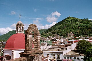
Tenancingo is one of 125 municipalities in the State of Mexico, Mexico. The municipal seat is the town of Tenancingo de Degollado. The municipality is located in the south of the state, in the Tenancingo Valley, just outside the Toluca Valley. The official name of the municipality is only Tenancingo but the town is Tenancingo de Degollado and is often confused with Tenancingo, Tlaxcala, which is a town in a different state.
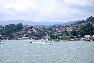
Valle de Bravo is one of 125 municipalities in the State of Mexico, Mexico. The largest town and municipal seat is the town of Valle de Bravo. It is located on the shore of Lake Avándaro, approximately 156 km southwest of Mexico City and west of Toluca on highways 15, 134 or 1. It takes about two hours to drive from Mexico City to Valle de Bravo, making it a popular weekend getaway for the capital's affluent upper class.

Ciudad Nicolás Romero is the largest city and municipal seat of the municipality of Nicolás Romero in State of Mexico, Mexico. It is located 58 km from the city of Toluca, the state capital and lies in the north-central part of the state, just northwest of the Federal District. The seat/municipality's current name is to honor Nicolás Romero, who fought for Benito Juárez during the Reform War and the French intervention in Mexico. He was executed there by the French. The town adopted this name in 1898. The area was settled by the Otomi and named Azcapotzaltongo by the Aztecs after conquering it. During colonial times, it was known as San Pedro Azcapotzaltongo. It was then called Monte Bajo from 1821 to 1898, when the current name was adopted. Both the municipality and city are commonly referred to as Nicolás Romero.

Zinacantepec is a municipality located just west of the city of Toluca in Mexico State, Mexico. The municipal seat is the town of San Miguel Zinacantepec. Zinacantepec is Nahuatl for "bat mountain" and its Aztec glyph is a bat on a mountain. It is named after a small mountain which contained two caves which used to be filled with thousands of bats.
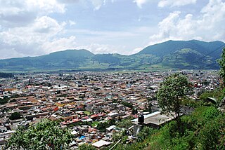
The municipality of Tenango del Valle is located in the southern portion of the Valley of Toluca in Mexico State, about 72 km southwest of Mexico City and 25 km south of Toluca. The municipal seat is the city of Tenango de Arista. While the seat is officially named Tenango de Arista, it is more commonly referred to as Tenango del Valle, as this was the original name of the town. Tenango del Valle is best known as the site of the Teotenango archeological site, which was a walled city inhabited from about 900 C.E. to 1550 C.E.
Tejupilco de Hidalgo is the seat of Tejupilco Municipality in the State of Mexico, Mexico. It is located approximately 100 kilometres (62 mi) southwest of the state capital Toluca, along Federal Highway 34. The name Tejupilco comes from Náhuatl meaning "between the toes". "De Hidalgo" was added to honor Father Miguel Hidalgo who initiated the Mexican War of Independence.
Tlatlaya is one of 125 municipalities of the State of Mexico in Mexico. The municipal seat is the town of Tlatlaya which is the eleventh largest town in the municipality. The word “Tlatlaya” means when the hearth is black and red.
Jiquipilco Municipality is one of the municipalities of the State of Mexico in Mexico. It is north of the Toluca Valley, part of the region consisting of the southern and western slopes of Cerro La Catedral, which has a concentration of speakers of the Otomi language. It is about 40 km from Toluca, the state capital. The name is a corruption of Nahuatl “Xiquipilco”, meaning “in the saddlebags”. Jiquipilco is situated on the transversal volcanic axis that crosses Mexico in an area surrounded by lakes and volcanoes. This portion is called "Anahuac”.

Acambay is a town and municipio (municipality) located in northern State of Mexico. The township of Acambay is the municipal seat of the municipio of the same name.
San Jose Villa de Allende is a town and municipal seat of the municipality of Villa de Allende. It is the fifth largest town in the municipality. It is located 70 kilometers to the west of the city of Toluca. Villa de Allende was named in honor of Ignacio Allende, a hero of the Mexican War of Independence.
Santo Tomás de los Plátanos also known as Nuevo Santo Tomás de los Plátanos is a town and municipal seat of the municipality of Santo Tomás, located in the center-west of Mexico State, in Mexico. It is approximately 185 km from Mexico City, and 107 km from Toluca.
Otzoloapan Municipality is a municipality located at the southeast of the State of Mexico. The name is from the Náhuatl 'Oceloapan' which means "river of lynxes". It is located in the southwest part of the state bordering the state of Michoacán.

El Oro is one of 125 municipalities in the State of Mexico within the United Mexican States. The municipal seat is the town of El Oro de Hidalgo. The name El Oro means "the gold" in Spanish. It has subsequently been given an alternative Nahuatl name of "Teocuitlatl", meaning "sacred excrement". Its seal, in the form of an Aztec glyph, contains elements referring to gold and to caves, of which there are many in the municipality.
Tejupilco is a municipality in the State of Mexico, Mexico, located approximately 100 kilometres (62 mi) southwest of the state capital Toluca, along Federal Highway 134. Its municipal seat is Tejupilco de Hidalgo. The municipality has a total area of about 1,327 km2 (512 sq mi), with a contrasting topography ranging from deep ravines and canyons to high ridges; the highest elevation within the municipality reaches some 1,117 metres (3,660 ft) asl. The 2005 census recorded a population of 62,547 inhabitants.
Temascalcingo is one of 125 municipalities in the State of Mexico, Mexico. The municipal seat is the town of Temascalcingo de José María Velasco. It is located in the northeast of the state. The temazcal was very common in Temascalcingo. The name Temascalcingo has its roots in Nahuatl. It means place of the little temazcal. The town is one of the "Pueblo con Encanto" of the State of Mexico.
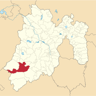
Luvianos is a small town and municipality located in the southwest of the State of Mexico. It gained municipal status in 2000. People can access Luvianos by driving Federal Road 134 south from Toluca, and then take a detour about 25 minutes north of Tejupilco. The name is derived from a hacienda what was established during colonial times.

Santiago Papasquiaro is one of the 39 municipalities of Durango, in north-western Mexico. The municipal seat lies at Santiago Papasquiaro. The municipality covers an area of 7,238.4 km². Santiago Papasquiaro municipality is at an average height of 1,730 m (5,675 ft) over the sea level. The municipality lies east of Sierra Madre Occidental Mountain Range. It neighbors with other municipalities: Canelas and Tepehuanes municipalities at the north; San Dimas and Otáez, south; Nuevo Ideal to the east, Tamazula to the west and El Oro located northeast.