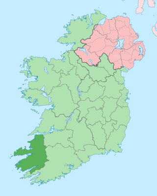
County Kerry is a county on the southwest coast of Ireland, within the province of Munster and the Southern Region. It is bordered by two other counties; Limerick to the east, and Cork to the south and east. It is separated from Clare to the north by the Shannon Estuary. With an area of 4,807 square kilometres (1,856 sq mi) and a population of 156,458 as of 2022, it is the 5th largest of Ireland's 32 counties by land area, and the 15th most populous. The governing local authority is Kerry County Council.

Valentia Island is one of Ireland's most westerly points. It lies off the Iveragh Peninsula in the southwest of County Kerry. It is linked to the mainland by the Maurice O'Neill Memorial Bridge at Portmagee. A car ferry also departs from Reenard Point to Knightstown, the island's main settlement, from April to October. Another, smaller village named Chapeltown sits at roughly the midpoint of the island, three kilometres from the bridge. Valentia Island's permanent population is 658. It is about 11 kilometres long by almost three kilometres wide, making it the fifth-biggest island off the Irish coast.

Kenmare is a small town in the south of County Kerry, Ireland. The name Kenmare is the anglicised form of Ceann Mara, meaning "head of the sea", referring to the head of Kenmare Bay. It is also a townland and civil parish.

The Iveragh Peninsula is located in County Kerry in Ireland. It is the largest peninsula in southwestern Ireland. A mountain range, the MacGillycuddy's Reeks, lies in the centre of the peninsula. Carrauntoohil, its highest mountain, is also the highest peak in Ireland.
Killorglin is a town in County Kerry, Ireland. As of the 2022 census, the town's population was 2,163. Killorglin is on the Ring of Kerry tourist route, and annual events include the August Puck Fair festival, which starts with the crowning and parading of a "king" wild goat. The town is 26 km south of Tralee along the N70 road, and 22 km west of Killarney along the N72 road. Killorglin is in a civil parish of the same name.

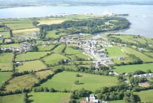
Knightstown, alternatively called Knight's Town, is a village and the largest settlement on Valentia Island, County Kerry, in Ireland. It lies within the townland of Farranreagh, at the eastern tip of the island. As of the CSO census of 2022, Knightstown had a population of 244.

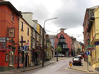
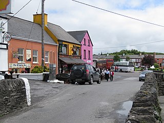
Portmagee is a village in County Kerry, Ireland. The village is located on the Iveragh peninsula south of Valentia Island, and is known locally as 'the ferry', in reference to its purpose as a crossing point to the island. Access to Valentia Island is now via the Maurice O'Neill Memorial Bridge from Portmagee, which was built in 1970 and named in memory of a member of the IRA executed in 1942 for his part in the shooting dead of Detective George Mordaunt in Dublin.

Waterville, historically known as Coirean, is a village in County Kerry, Ireland, on the Iveragh Peninsula. The town is sited on a narrow isthmus, with Lough Currane on the east side of the town, and Ballinskelligs Bay on the west, and the Currane River connecting the two.

Adare is a village in County Limerick, Ireland, located southwest of the city of Limerick. Adare is designated as a heritage town by the Irish government. The village is in a townland and civil parish of the same name.

Raheny is a northern suburb of Dublin, Ireland, halfway from the city centre to Howth. It is centred on a historic settlement, first documented in 570 AD. The district shares Dublin's two largest municipal parks, Saint Anne's Park and Bull Island with its 4.5 km beach, with neighbouring Clontarf, and is crossed by several small watercourses.
Michael O'Connell is an Irish former Gaelic footballer. Throughout his 25-year club career, he played for Young Islanders, winning seven South Kerry Championship titles during a golden age for the club; he also played for divisional side South Kerry, and experienced success in the County Championship. At inter-county level, he captained Kerry to win the 1959 All-Ireland Championship; he later claimed a further three All-Ireland medals, as well as Munster Championship and National League successes.
Sneem is a village situated on the Iveragh Peninsula, in County Kerry, in the southwest of Ireland. It lies on the estuary of the River Sneem which expands here to Kenmare Bay. The N70 road runs through the town, which is approximately 22 kilometres (14 mi) west of Kenmare. While the 2022 census recorded a population of 386 people, Sneem is located in a tourist area and the population increases during the summer months.

Mayobridge is a village within County Down, Northern Ireland. It lies on the small river Clanrye, which divides the townlands of Mayo and Bavan, 4.4 miles (7.1 km) east of Newry. It had a population of 1,069 as at 2011. Administratively, it is within the Newry and Mourne District Council area, and falls within the parish of Clonallan, and historically within the barony of Iveagh Upper, Upper Half.
Tarbert is a village in the north of County Kerry, with woodland to the south and the Shannon estuary to the north. It lies on the N69 coast road that runs along the estuary from Limerick before turning inland at Tarbert towards Listowel. As of the 2022 census, Tarbert village had a population of 546.

Ballylongford is a village near Listowel in northern County Kerry, Ireland.

Rolestown, is a small village six miles (10 km) north-west of Swords along the R125 in Fingal, County Dublin, Ireland. It lies about halfway between Swords and Ashbourne, County Meath. It is located around two parallel roads intersected by a road that crosses the Broadmeadow River by an old cut stone bridge. Rolestown is also a parish in the Fingal North deanery of the Roman Catholic Archdiocese of Dublin.
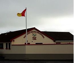
Valentia Young Islanders are a Gaelic Athletic Association club from Valentia Island, South County Kerry, Ireland. They play in Division 4 of the county league and in the Kerry Novice Football Championship. The club's most recent success has been winning the Munster Junior football championship final after beating Kildimo-Pallaskenry 12 points to 1-8 on 25 January 2015.

Knockbridge is a village in County Louth, Ireland. 7 km south-west of Dundalk, it is in the townland of Ballinlough in the historical barony of Dundalk Upper. As of the 2022 census, the village had a population of 759 people. Knockbridge won a "best kept village" award in the 2008 Tidy Towns competition.

Portroe is a village in County Tipperary, Ireland. The village is located on the R494 regional road, 2km from the eastern shore of Lough Derg and 11km west of the town of Nenagh. Portroe spans the townlands of Garrykennedy, Glencrue and Shesharoe.

The R565 road is a regional road in County Kerry, in south-western Ireland. It is 18.5 km (11.5 mi) long and runs along the Iveragh Peninsula and Valentia Island. The road has two crossings to the island; the permanent Maurice O'Neill Memorial Bridge, and a seasonal vehicle ferry at Knightstown.