Asdee

Last updated

Asdee
Eas Daoi
Village
Ireland adm location map.svg
Red pog.svg
Asdee
Location in Ireland
Coordinates: 52°33′07″N9°33′36″W / 52.552°N 9.560°W / 52.552; -9.560
Country Ireland
Province Munster
County Kerry
Time zone UTC+0 (WET)
  Summer (DST) UTC-1 (IST (WEST))

Asdee or Astee (from Irish Eas Daoi [1] meaning the "black waterfall") is a small village in County Kerry, Ireland.

Contents

History

Ringforts on the outskirts of Asdee Village. Asdee Forts.jpg
Ringforts on the outskirts of Asdee Village.

Evidence of ancient settlement in the area includes a number of ringfort sites, to the west of the village, which were built between 600AD and 900AD. [2]

At the turn of the 12th century, the O'Connors, Kings of Kerry, moved from their stronghold at Doon Point (Ballybunion) to Clár an Easa Duibhe (meaning "plain of the black waterfall"), where the village is now situated. This move was undertaken to facilitate an alliance between the O'Connors and the O'Brien dynasty, then Kings of Thomond. The waters around Clár an Easa Duibhe allowed the O'Connors passage to the O'Brien stronghold of what is now County Clare.

By 1146, the O'Connor's had built a castle in the area and the area became known as Caisleán Easa Duibhe, or "castle of the black waterfall". Three kingships ruled from Caisleán Easa Duibhe, before the O'Connors moved to Carrigafoyle Castle (near Ballylongford) at the end of the 12th century. The castle in Caisleán Easa Duibhe subsequently fell into disrepair, and some of the stone from the castle was ultimately used in the building of three houses beside the church in the village. [2]

The black waterfall, from where the village gets its name, was quarried prior to the mid-18th century, leaving a smaller version of the original waterfall remaining a short distance upstream of the village. [2]

Jesse James

The village has an association with Jesse James, whose ancestor, John James, lived in Asdee, having moved from the United Kingdom, before migrating to the United States in the mid-17th century. Jesse James was born in Kearney, Missouri in 1847, going on to become one of the most well-known outlaws in the American Wild West. [2]

Amenities

Beach

Sunset on Littor Strand Littor Sunset.jpg
Sunset on Littor Strand

Littor Strand is a Green Flag beach which stretches along the estuary into the adjoining Beale Beach. The nearby estuary is home to Bottlenose Dolphins and migrant waders and Brent Geese. The beach also plays host to several resident species of birdlife, including Oystercatchers, Curlews, Dunlins, and several types of Seagull.[ citation needed ]

Shannon Way Trail

View from the Shannon Way Trail Hill-View.jpg
View from the Shannon Way Trail

The Shannon Way Walking Trail gives views of the Shannon Estuary. Stretching from Cnoc an Óir to Tarbert, the trail gives views of North Kerry, Clare, Limerick, and as far as Galway on a clear day. [2]

Built heritage

Tullahinell House

Tullahinell House, known locally as "The Buildings", was the former landlord's residence of Maxwell V. Blacker-Douglas. During the Great Famine of the mid-19th century, Douglas provided employment on his farm for some people in the area. [2]

There was a mill here in the late-1800s, the stream for which no longer exists, having originally been artificially diverted.

During the Irish War of Independence (1919–1921), "The Buildings" was sometimes used as a refuge for members of the Irish Republican Army. During this period, it also hosted a meeting of senior Republican figures, including Cathal Brugha and Arthur Griffith. [2]

Church

The church in the village was built in 1835 and extended and renovated in 1964. Its original construction was largely funded by the Hickie family. Originally from County Clare, ancestors of the Hickies had been hereditary physicians to the Kings of Munster, before their lands were confiscated in the 1650s following the Cromwellian conquest of Ireland. After moving to the area, the family built Kilelton House, between Asdee and Ballylongford. [2]

St Eoin's well

St Eoin's Well, located near the village, hosts an annual mass every June. This holy well was traditionally believed to have healing properties. [2]

See also

Related Research Articles

<span class="mw-page-title-main">Bunratty Castle</span> Castle in Ireland

Bunratty Castle is a large 15th-century tower house in County Clare, Ireland. It is located in the centre of Bunratty village, by the N18 road between Limerick and Ennis, near Shannon Town and its airport. The castle and the adjoining folk park are run by Shannon Heritage as tourist attractions.

<span class="mw-page-title-main">Castleconnell</span> Village in County Limerick, Ireland

Castleconnell is a village in County Limerick on the banks of the River Shannon. It is 11 km (6.8 mi) from Limerick city and near the boundaries of County Clare and County Tipperary.

<span class="mw-page-title-main">Cratloe</span> Village in County Clare, Ireland

Cratloe is a village in County Clare, Ireland, situated between Limerick and Shannon in the mid-west of Ireland. It is possible that the name derives from Croit-shliabh meaning "hump-backed hill", referring to Woodcock Hill. The present-day parish of Cratloe consists of the former parish of Kilfintinan and a portion of the contemporary parish of Killeely. This was agreed upon by priests in the 18th century, who claimed there were not enough members of the clergy to operate fully in both parishes.

<span class="mw-page-title-main">O'Dea Castle</span> Fortified tower house in Ireland

O'Dea Castle, also known as Dysert O'Dea Castle, is an Irish fortified tower house, loosely described as a castle at Dysert O'Dea, the former O'Dea clan stronghold, 5 kilometres (3 mi) from Corofin, County Clare. It was built between 1470 and 1490 by Diarmaid O'Dea, Lord of Cineal Fearmaic, and stands some 50 feet (15 m) high on a limestone outcrop base measuring 20 by 40 feet. The tower is adjacent to Dysert O'Dea Monastery, close to the R476 road.

The Battle of Dysert O'Dea took place on 10 May 1318 at Dysert O'Dea near Corofin, Ireland. It was part of the Bruce campaign in Ireland. The Norman Richard de Clare attacked the Gaelic Irish chieftain Conchobhar Ó Deághaidh, chief of the Cineal Fearmaic and ally of Muircheartach Ó Briain, but he was defeated.

<span class="mw-page-title-main">Askeaton</span> Town in County Limerick, Ireland

Askeaton is a town in County Limerick, Ireland. The town is built on the banks of the River Deel which flows into the Shannon Estuary 3 km to the north. Askeaton is on the N69 road between Limerick and Tralee; it is 25 km west of Limerick and 8 km north of Rathkeale.

<span class="mw-page-title-main">Kilrush</span> Town in County Clare, Ireland

Kilrush is a coastal town in County Clare, Ireland. It is also the name of a civil parish and an ecclesiastical parish in Roman Catholic Diocese of Killaloe. It is located near the mouth of the River Shannon in the south-west of the county. Kilrush is one of the listed Heritage Towns of Ireland. The area was officially classified as part of the West Clare Gaeltacht, an Irish-speaking community, until 1956.

<span class="mw-page-title-main">Clarecastle</span> Village in County Clare, Ireland

Clarecastle is a village just south of Ennis in County Clare, Ireland. From 2008 to 2016 the village saw a significant population increase due to its proximity to Ennis, Shannon, and Limerick.

<span class="mw-page-title-main">Doonagore Castle</span> Tower house in County Clare, Ireland

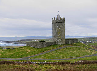
Doonagore Castle is a round 16th-century tower house with a small walled enclosure located about 1 km south of the coastal village of Doolin in County Clare, Ireland. Its name may be derived from Dún na Gabhair, meaning "the fort of the rounded hills" or the "fort of the goats". Doonagore Castle is at present a private holiday home, inaccessible to the public.

<span class="mw-page-title-main">Newcastle, County Wicklow</span> Village in County Wicklow, Ireland

Newcastle is a village in County Wicklow, Ireland. It is situated on the R761 and is about 45 km (28 mi) south of Dublin city. Newcastle had a population of 924 as of the 2016 census. The ancient barony of Newcastle, which surrounds the village, takes its name from the village and its Norman castle.

<span class="mw-page-title-main">Siege of Carrigafoyle Castle</span> 16th-century siege in Kerry, Ireland

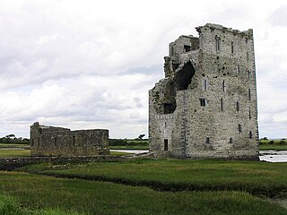
The siege of Carrigafoyle Castle took place on Easter in 1580 near modern-day Ballylongford, County Kerry, Ireland, on the southern bank of the Shannon estuary. The engagement was part of the English crown's campaign against the forces of Gerald FitzGerald, 14th Earl of Desmond during the Second Desmond Rebellion. The castle was held by rebel troops in the service of Desmond and some Catholic troops from continental Europe.

<span class="mw-page-title-main">Ballylongford</span> Village in County Kerry, Ireland

Ballylongford is a village near Listowel in northern County Kerry, Ireland.

<span class="mw-page-title-main">Carrigaholt</span> Fishing village in County Clare, Ireland

Carrigaholt is a small fishing village in County Clare, Ireland, a castle and a Catholic parish by the same name. The area was officially classified as part of the West Clare Gaeltacht; an Irish-speaking community; until 1956.

<span class="mw-page-title-main">Ballinalacken Castle</span> Tower house in Killilagh parish, Ireland

Ballinalacken Castle is a two-stage tower house located in Killilagh parish of County Clare, Ireland. It is of uncertain date but most likely was built in the 15th or early 16th century.

<span class="mw-page-title-main">Shannon Estuary</span> River in Kerry, Ireland

The Shannon Estuary in Ireland is a large estuary where the River Shannon flows into the Atlantic Ocean. The estuary has Limerick City at its head and its seaward limits are marked by Loop Head to the north and Kerry Head to the south. The estuary defines the main boundary between County Kerry/County Limerick to the south and County Clare to the north.

<span class="mw-page-title-main">Dough Castle</span> Ruined tower house in County Clare, Ireland

Dough Castle is a ruined tower house at Lahinch in County Clare, western Ireland. It was established by the O'Conors in the early 14th century, but nothing remains of the original structures.

<span class="mw-page-title-main">Wild Atlantic Way</span> Irish coastal 2,500 km road route

The Wild Atlantic Way is a tourism trail on the west coast, and on parts of the north and south coasts, of Ireland. The 2,500 km driving route passes through nine counties and three provinces, stretching from County Donegal's Inishowen Peninsula in Ulster to Kinsale, County Cork, in Munster, on the Celtic Sea coast.

<span class="mw-page-title-main">Shannon River Basin</span> River in Ireland

The Shannon River Basin consists of the area containing Ireland's longest river, the River Shannon, and all of its tributaries and lakes. The official Ordnance Survey Ireland length of the Shannon from its Shannon Pot source is 224 miles (360 km) made up of 63.5 miles (102.2 km) tidal water flow and 160.5 miles (258.3 km) freshwater flow.

Shannon Rangers is a North Kerry Divisional Gaelic football team in County Kerry, Ireland, based around the Shannon Estuary. Founded in 1940, the team compete in the Kerry Senior Football Championship, which they have won on 5 occasions. They also won the inaugural Munster Senior Club Football Championship in 1964.

<span class="mw-page-title-main">Lislaughtin Abbey</span>

Lislaughtin Abbey is a medieval Franciscan friary and National Monument located in County Kerry, Ireland.

References

  1. "Eas Daoi / Astee". logainm.ie. Placenames Database of Ireland . Retrieved 2 September 2022.
  2. 1 2 3 4 5 6 7 8 9 "About - A Brief History of Asdee". asdeevillage.com.