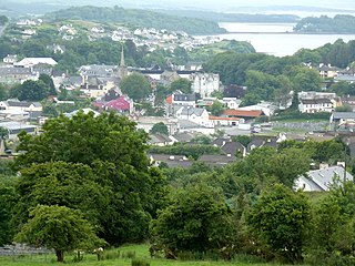
Ardfert (Irish: Ard Fhearta, meaning 'the hill of miracles') is a village and civil parish in County Kerry, Ireland. Historically a religious centre, the economy of the locality is driven by agriculture and its position as a dormitory town, being only 8km (5mi) from Tralee. The population of the village was 749 at the 2016 census.[2]
The village's name signifies, according to Sir James Ware, "a wonderful place on an eminence", or as some interpret it, "the hill of miracles." Ardfert has also been considered a corruption of Ard Ert, "the high place of Ert or Erc", so called after the fifth century Irish Bishop Saint Erc, who made the place a bishop's seat. Ardfert was written by the Four Masters as Ard-ferta, the height of the grave.[3]
History
Ardfert is a parish in the Barony of Clanmaurice, County Kerry, Ireland, anciently in the territory of Ui Fearba/Hy Ferba, of which the O'Laeghain (O'Leyne, Leen or Lane) were once the Gaelic Lords, until Norman invasion of Ireland.
Ardfert Cathedral
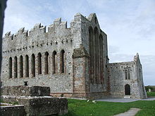
Ardfert is the home of St. Brendan's Ardfert Cathedral, which was destroyed in the Irish Rebellion of 1641, and the birthplace of St. Brendan the Navigator, who was educated about the year 500 AD. He founded a monastery there in the sixth century, but both town and monastery were destroyed by fire in 1089, and again in 1151.
The Norman influence can still be seen not only in the architecture, but also in local family surnames such as the Cantillons (Barons de Ballyheigue), and Fitzmaurices,[citation needed] and in place names, such as Ballintobeenig, a nearby townland below Mt. Crusline called after St. Aubin.[4]Thomas FitzMaurice, 1st Baron Kerry founded a Franciscan friary there in 1253, and Nicholas, the 2nd Lord Kerry, built a leper house there in 1312. It was the seat of a bishopric until 1660.
The CrusaderKnights Hospitaller of the Order of Saint John of Jerusalem (later known as Knights of Malta), also had some rights in Ardfert, although there is a record of a dispute between them and the Franciscans in 1325 about the market cross and pillory. They had already been established in the area in c. 1200 when Meiler FitzHenry, grandson of King Henry I of England, and Justiciar of Ireland under King John, established a preceptory at Rattoo under a Fra' William from Dublin.[5] Under the terms of a royal grant in letters patent of James I of England on 6 July 1612, the Lord of Kerry (FitzMaurice) could hold courts baron and leet.
The Annals of the Kingdom of Ireland, recount how in 1601, Prince Hugh Roe O'Donnell, on his way to the Battle of Kinsale, sent some of his kinsmen troops there to reconquer Ardfert, Lixnaw, and Ballykeally for his ally FitzMaurice. En route, he visited and venerated a relic of the True Cross (Holy rood) on the Feast of St. Andrew, on 30 November 1601, at Holy Cross Abbey, near Thurles, County Tipperary, which was a rallying point for the defence of religious freedom and for Irish sovereignty. From there he sent an expedition to Ardfert, to win a quick victory and recover the territory of his ally, Fitzmaurice, Lord of Kerry, who had lost it and his 9-year-old son, to Sir Charles Wilmot. The expedition captured Caislean Gearr (Short Castle, of which no trace remains), adjacent to the Cathedral in Ardfert. An O'Donnell from Tyrconnell remained behind in stewardship to hold it, according to "The Life of Hugh Roe O'Donnell, Prince of Tyrconnell"written by Lughaidh O'Cléirigh, circa 1603 in Gaelic.[6]
Tomb of John O'Donnell in the grounds of Ardfert Cathedral
A large tomb in the grounds of the cathedral was built much later by John O'Donnell (1803–1879), the most prominent descendant two centuries later, and whose own direct male descendant was the late Patrick Denis O'Donnell (1922–2005), the Irish military historian. He owned the summit overlooking Ardfert (Mt. Crusline, Ballintobeenig, from where his ancestral O'Donnell of Tyrconnell, under authority of Prince Hugh Roe O'Donnell would have launched the battle to regain Ardfert for Lord Kerry in 1601). The family seat of John O'Donnell, at Tubrid mentioned by Samuel Lewis in his 1837 Topographical Dictionary of Ireland, passed through a female line to the O'Carrolls. The house expanded by John O'Donnell in Tubridmore was listed as an intended "protected structure" in the archaeological monuments section of the draft Kerry County Development Plan 2015–2021.[7]
In the early 19th century, the Earl of Listowel (Hare) was Lord of the Manor and held court every three weeks in Ardfert, through an appointed Seneschal, having bought those rights from the Earl of Kerry, Fitzmaurice.
Ardfert Friary
The area's archaeological heritage includes the medieval cathedral, St. Brendan's, and associated churches, Temple na Hoe (Church of the young Virgin) and Temple na Griffin. Several have these have become heritage tourism attractions in the Kerry area due to their central location.[citation needed] The 13th century Franciscan Friary, to the north east of the village, was once an integral part of Ardfert Abbey - not an abbey at all but the name of the Talbot-Crosbie mansion destroyed by fire in 1922 by the IRA.
Five other structures included on the Record of Protected Structures (RPS) are located in Ardfert; St Brendan's Catholic Church (consecrated in 1855), the Old Gates of the Earl of Glandore's Demesne, the Talbot-Crosbie Memorial, the Ardfert Parish Room (now a site registered as derelict by Kerry County Council) and Brandon House. There are also many other structures within the village which are not included in the RPS, but are considered to be of considerable architectural and heritage value, such as the Ardfert Retreat Center.[citation needed] Also nearby are the surviving estate walls which contribute to the character and identity of the village.[citation needed]
In the 20 years between the 1996 and 2016 census of Ireland, the population of Ardfert village increased from 648 to 749 inhabitants.[8]
It is located within an agricultural area, surrounded by flat and low-lying land.[9] The main Tralee-Ballyheigue road bisects the village in an east–west axis, with road width restrictions on the western side of the village. To the north of the village, the Tyshe River traverses the village road network.[9] The village settlement pattern is radial and dispersed and consists of a mixture of single site depth development along radial roads interspersed with housing estates. Within the core of the village there is a mix of dwelling types of various traditional designs. More modern design predominates in the one-off housing on the radial routes. The development of a central retail and social node has been constrained to some extent by need to protect historic buildings and monuments within the village.[citation needed]
Economy and amenities
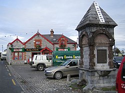
The village provides a number of goods and services to the local area and surrounding agricultural hinterland.[citation needed] Other developments have increased its role as a dormitory suburb for Tralee. The village also acts as a convenience stop for tourist and local through traffic.[citation needed] The village is served by social and retail services, including a Garda station, An Postpost office, health centre, garage, petrol station and a number of retail outlets and public houses. In addition there is a Roman Catholic Church, a school and a community centre with gym and launderette. Planning permission for residential development has recently[when?] been permitted on the existing Gaelic Athletic Association (GAA) grounds, with replacement facilities planned elsewhere on the periphery of the village.[citation needed]
Transport
Ardfert is located on the R551 regional road from Tralee to Ballyheigue. The village centre is located at a crossroads between the R551 and several local roads. The traffic is increased by the quarry to the north east of the village which generates HGV traffic movements through the village.[citation needed] During the summer months, the situation is exacerbated by tourist traffic to coastal locations.[citation needed] The Tralee-Ballyheigue road at the northern end of the village sees bottleneck delays in traffic into and out of the village.[citation needed]
Ardfert railway station, on the line from Limerick to Tralee via Newcastle West, opened on 20 December 1880. The station closed to passengers on 4 February 1963, and to freight on 2 June 1978.[10] The track was lifted in 1988.
A short lived greyhound racing track was opened in the village on 21 August 1929. The venture run by the Kingdom Greyhound Racing Club and only lasted until Wednesday 25 September 1929. The last race was the Ardfert Stake which was won by Captain Off, the even money favourite. The main reason for the closure was the fact that a larger track called Oakview Park (to the south in Oakview Village) was due to open.[13]
The eventing horse "Village Gossip", ridden between 1976 and 1985 by British team rider Lucinda Green (née Prior Palmer), was born and bred in Ardfert. He completed Badminton Horse Trials on several occasions, placing second in 1978 and was the fastest competitor at the World Three Day Event in Lexington, Kentucky, the same year.[citation needed]
Ardfert in Times Past, Tommy O'Connor, 1999, ISBN0951573616
Ardfert Church 150: A history of St. Brendan's Church, Ardfert 1855 - 2005, Tommy O'Connor, 2005
Annals of the Kingdom of Ireland (Annála Ríoghachta Éireann) by the Four Masters, from the earliest period to the year 1616, compiled during the period 1632-1636 by Brother Michael O'Clery, translated and edited by John O'Donovan in 1856, and re-published in 1998 by De Burca, Dublin (Volume VI, page 2279).
The Life of Hugh Roe O'Donnell, Prince of Tyrconnell (Beatha Aodh Ruadh O Domhnaill) by Lughaidh O'Cleirigh. translated with notes by Rev. Denis Murphy, S.J., M.R.I.A., and published by Sealy, Bryers, & Walker, Dublin, 1893 (pages 305–307); also later edition edited by Paul Walsh and Colm Ó Lochlainn. Irish Texts Society, vol. 42. Dublin: Educational Company of Ireland, 1948 (original Gaelic manuscript in the Royal Irish Academy in Dublin).
A Topographical Dictionary of Ireland (Two Volumes), by Samuel Lewis, London, 1837 (see entry on Ardfert in Volume I, pages 47–50)
Discovering Kerry; its History, Heritage and Topography, by T.J. Barrington, Blackwater Press, Dublin, 1976 (pages 252–255).
Vanishing Kingdoms - The Irish Chiefs and Their Families, by Walter J. P. Curley (former US Ambassador to Ireland), with foreword by Charles Lysaght, published by The Lilliput Press, Dublin, 2004 [ ISBN1-84351-055-3 & ISBN1-84351-056-1]. (Chapter on O'Donnell of Tyrconnell, page 59).
Related Research Articles
Tralee is the county town of County Kerry in the south-west of Ireland. The town is on the northern side of the neck of the Dingle Peninsula, and is the largest town in County Kerry. The town's population was 26,079 as of the 2022 census, making it the 15th largest urban settlement in Ireland. Tralee is known for the Rose of Tralee International Festival, which has been held annually in August since 1959.
The Flight of the Earls took place in September 1607, when Hugh O'Neill, Earl of Tyrone, and Rory O'Donnell, 1st Earl of Tyrconnell, and about ninety followers, left Ulster in Ireland for mainland Europe. Their permanent exile was a watershed event in Irish history, symbolizing the end of the old Gaelic order.
Rory O'Donnell, 1st Earl of Tyrconnell, was an Irish Gaelic lord, the last King of Tyrconnell. He was a younger brother of Hugh Roe O'Donnell and became the 1st Earl of Tyrconnell.
Donegal is a town in County Donegal in Ulster, the northern province in Ireland. Although Donegal gave its name to the county, now Lifford is the county town. From the 15th until the early 17th century, Donegal was the "capital" of Tyrconnell, a Gaelic kingdom controlled by the O'Donnell dynasty of the Northern Uí Néill.
Ballyheigue, officially Ballyheige, is a coastal town and civil parish in County Kerry, Ireland. It is 18 km (11 mi) northwest of Tralee along the R551 road. It is a scenic locale which forms part of the Wild Atlantic Way and has several miles of beaches that connect to Banna Strand to the south, and Kerry Head to the north. Local events include the Half on the Head (Kerryhead) half marathon in June and an annual summer festival in July.
Abbeyfeale is a historic market town in County Limerick, Ireland, near the border with County Kerry. The town is on the N21 road from Limerick to Tralee, some 21 kilometres south-west of Newcastle West and 16 kilometres south-east of Listowel and 38 kilometres north-east of Tralee. The town is in a civil parish of the same name.
Hugh Roe O'Donnell, also known as Red Hugh O'Donnell, was a sixteenth-century Irish clan chief, Lord of Tyrconnell, and senior leader during the rising of the Irish clans against English rule in Ireland known as the Nine Years War (1593-1602). While Hiram Morgan has contemptuously dubbed Hugh Roe O'Donnell, "a counter-reformation Irish dynast living in the world of Machiavelli's Prince rather than The Cattle-Raid of Cooley", Morgan also concedes that primary sources other than the Elizabethan era English officials who wrote the Calendar of State Papers depict Hugh Roe as a man who genuinely believed in and lived by the traditional code of conduct demanded of an Irish clan chief. For this reason, Hugh Roe remains an iconic figure in the history of Irish nationalism and has recently drawn comparisons in the Spanish news media to both El Cid and William Wallace.
The Ardfert Cathedral is a ruined cathedral in Ardfert, County Kerry, Ireland. Dedicated to Saint Brendan, it was the seat of the Diocese of Ardfert from 1117. It is now a heritage tourism site.
The O'Donnell dynasty were the dominant Irish clan of the kingdom of Tyrconnell in Ulster in the north of medieval and early modern Ireland.
Earl of Tyrconnell is a title that has been created four times in the Peerage of Ireland.
Tyrconnell, also spelled Tirconnell and Tirconaill, was a kingdom of Gaelic Ireland. It is associated geographically with present-day County Donegal, which was officially named County Tirconaill between 1922 and 1927. At times it also included parts of County Fermanagh, County Sligo, County Leitrim, County Tyrone and County Londonderry at its greatest extent. The kingdom represented the core homeland of the Cenél Conaill people of the Northern Uí Néill and although they ruled, there were smaller groups of other Gaels in the area.
Holy Cross Abbey(Mainistir na Croise Naofa) was a Cistercian monastery in Holycross near Thurles, County Tipperary, Ireland, situated on the River Suir. It takes its name from a relic of the True Cross or Holy Rood.
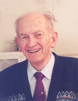
Patrick Denis O'Donnell was an Irish military historian, writer, former UN peace-keeper, and Commandant of the Irish Defence Forces.
Denis O'Donnell was an entrepreneur in County Kerry, Ireland, in the early 1900s. He was the organiser, co-founder, and first manager of the Lee Strand Cooperative Creamery, established based of the influence from the co-operative movement of Sir Horace Plunkett and the emerging spirit of national self-sufficiency.
The Kerry Senior Hurling Championship is an annual hurling competition organised by the Kerry County Board of the Gaelic Athletic Association since 1889 for the top hurling teams in the county of Kerry in Ireland.
Tralee Bay is located in on the west coast of County Kerry, Ireland. It is situated between Kerry Head on the north side and the Maharees on the west and extends eastwards as far as the bridge at Blennerville. Several small rivers feed into the bay through the town of Tralee. Villages around the bay include; Ballyheigue, Fenit, Kilfinora, Spa, Blennerville, Camp and Castlegregory.
Events from the year 1601 in Ireland.
Donegal Abbey is a ruined Franciscan Priory in Donegal in Ireland. It was constructed by the O'Donnell dynasty in the fifteenth century and remained a center of Classical Christian education even after its destruction during the Nine Years War. It is sometimes referred to as Donegal Friary.
Captain Humphrey Willis was an English soldier in Ireland in the sixteenth century, his parents are unknown. Captain Willis was appointed Sheriff of County Donegal and County Fermanagh by the Lord Deputy of Ireland William FitzWilliam. Captain Willis was a fluent speaker of Irish, and enforced his authority with a detachment of the Irish Army.
Ardfert Abbey, also known as Ardfert Friary, is a ruined medieval Franciscan friary and National Monument in Ardfert, County Kerry, Ireland. It is thought to be built on the site of an early Christian monastic site founded by Brendan the Navigator. The present remains date from the mid-thirteenth century, with the residential tower being added in the 15th century. The friary was dissolved in 1584.
↑ The Chevalier St. Aubin was a Knight Commander of the Knights of Malta, who ran against the naval blockade imposed by the Ottoman Turks during the Great Siege of Malta in 1565. See Malta 1565 - Last Battle of the Crusades, by Tim Pickles, published by Osprey Publishing, Oxford, UK, 1998 ISBN978-1-85532-603-3, page 33
↑ See pages 52 and 253, 254 and 256 of Discovering Kerry - its History, Heritage and Topography, by T. J. Barrington, published by The Blackwater Press, Dublin, 1976. ( ISBN0-905471-00-8)
↑ The following is an extract from The Life of Hugh Roe O'Donnell, Prince of Tyrconnell (Beatha Aodh Rua O Domhnaill) by Lughaidh O'Cleirigh (original Gaelic manuscript in the Royal Irish Academy in Dublin), translated with notes by Rev. Denis Murphy, S.J., M.R.I.A., and published by Sealy, Bryers, & Walker, Dublin, 1893 (pages 304-307): Ro tharmnaidheadh do mhuintir uí Dhomhnaill an turus do deachattor ar ro creachadh agus ro leirscriosadh sochaidhe leó do earccairdibh mic Muiris do neoch robtar fotha dia tocharsomh for longus agus ionnarbadh co húa nDomhnaill, agus ro gabhadh leó tri caisteoil do daghdúinibh an tíre, i. Leachsnamha, Caislén Gerr Arda Fearta, agus Baile Uí Chadhla, agus fosragaibhseat drong dia muintir occa niomchoimhéd. (pages 304, 306)
This page is based on this Wikipedia article Text is available under the CC BY-SA 4.0 license; additional terms may apply. Images, videos and audio are available under their respective licenses.