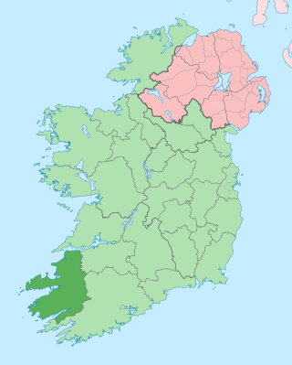
County Kerry is a county in Ireland. It is in the Southern Region and the province of Munster. It is named after the Ciarraige who lived in part of the present county. The population of the county was 155,258 at the 2022 census.

Tralee is the county town of County Kerry in the south-west of Ireland. The town is on the northern side of the neck of the Dingle Peninsula, and is the largest town in County Kerry. The town's population was 23,691 as of the 2016 census, thus making it the eighth largest town, and 14th largest urban settlement, in Ireland. Tralee is well known for the Rose of Tralee International Festival, which has been held annually in August since 1959.

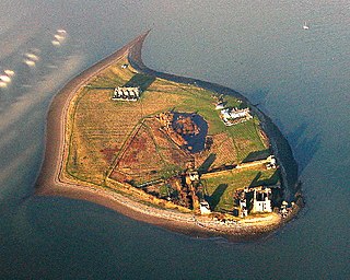
A tidal island is a piece of land that is connected to the mainland by a natural or man-made causeway that is exposed at low tide and submerged at high tide. Because of the mystique surrounding tidal islands, many of them have been sites of religious worship, such as Mont-Saint-Michel with its Benedictine Abbey. Tidal islands are also commonly the sites of fortresses because of their natural fortifications.

Castleisland is a town and commercial centre in County Kerry in south west Ireland. The town is known for the width of its main street. As of the 2016 Census, Castleisland had a population of 2,486.
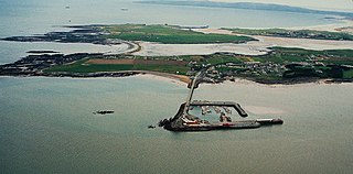
Piel Island lies in Morecambe Bay, around 1⁄2 mile off the southern tip of the Furness peninsula in the administrative county of Cumbria, England. It is one of the Islands of Furness, three of which sit near to Piel at the mouth of Walney Channel. The island is the location of Piel Castle, built by the monks of Furness Abbey in the fourteenth century.
Fenit is a small village in County Kerry, Ireland, located on north side of Tralee Bay about 10 km (6 mi) west of Tralee town, just south of the Shannon Estuary. The bay is enclosed from the Atlantic by the Maharee spit which extends northwards from the Dingle peninsula. Fenit harbour is a mixed function sea port, where fishing, freight import and export, and a 136 berth marina are the main forms of business. As of the 2016 CSO census of Ireland, Fenit had a population of 538 people.
Castlegregory is a village in County Kerry, Ireland. It is situated on the north side of the Dingle Peninsula, halfway between Tralee and Dingle. As of the 2016 Census, Castlegregory had a population of 250.
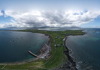
Maharees or Magharees is a 5 km long tombolo located on the northern side of the Dingle Peninsula in County Kerry, Ireland.
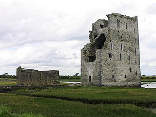
The siege of Carrigafoyle Castle took place on Easter in 1580 near modern-day Ballylongford, County Kerry, Ireland, on the southern bank of the Shannon estuary. The engagement was part of the English crown's campaign against the forces of Gerald FitzGerald, 14th Earl of Desmond during the Second Desmond Rebellion. The castle was held by rebel troops in the service of Desmond and some Catholic troops from continental Europe.
Tarbert is a town in the north of County Kerry, with woodland to the south and the Shannon estuary to the north. It lies on the N69 coast road that runs along the estuary from Limerick before turning inland at Tarbert towards Listowel, and has two schools Tarbert Primary and Tarbert Comprehensive.

Ballyseedy is a townland in County Kerry, Ireland. It was historically situated in the parish of Ballyseedy, within the barony of Trughanacmy. The townland contains a number of notable landmarks, including Ballyseedy Wood, a bridge over the Ballycarty River and a ruined Protestant church. There is also a large restored castle which is in use as a hotel.

Tralee Bay is located in on the west coast of County Kerry, Ireland. It is situated between Kerry Head on the north side and the Maharees on the west and extends eastwards as far as the bridge at Blennerville. Several small rivers feed into the bay through the town of Tralee. Villages around the bay include; Ballyheigue, Fenit, Kilfinora, Spa, Blennerville, Camp and Castlegregory.
Tralee Golf Club is an 18-hole links golf course, at Barrow, near Tralee, County Kerry, Ireland.
Trughanacmy is a barony in County Kerry, Ireland. The barony is an obsolete administrative area, having ceased to have any government function since the enactment of the Local Government (Ireland) Act 1898.

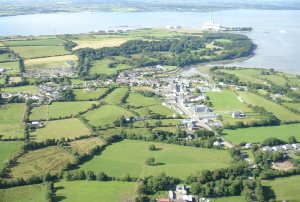
Blennerville is a small village and now a suburb of Tralee, County Kerry, Ireland. It is approximately 1 mile (1.6 km) west of the town centre on the N86 road to Dingle, where the River Lee enters Tralee Bay. The village was formerly Tralee's port, and is connected to the town centre by the Tralee Ship Canal. Part of Blennerville electoral division falls within the area of Tralee Town Council, and at the 2011 census had a population of 141. The remaining portion, outside the urban boundaries, had a 2011 population of 556.

The Tralee Ship Canal is a canal built for freight and passenger transportation from Tralee Bay to the town of Tralee in County Kerry, Ireland. The canal fell into disuse in the mid-20th century but has since been restored.

Spa is a village in County Kerry, Ireland. It is located on the R558 regional road between Tralee and Fenit, overlooking Tralee Bay. Spa lies in the historical barony of Trughanacmy.

Ballyheigue Castle, in Ballyheigue, County Kerry, is a ruined Tudor-gothic-revival-style mansion. It was used as a residence of the Crosbie family and later as a gaol. It has been burned twice. It is currently part of a golf course.


