County Kerry is a county on the southwest coast of Ireland, within the province of Munster and the Southern Region. It is bordered by two other counties; Limerick to the east, and Cork to the south and east. It is separated from Clare to the north by the Shannon Estuary. With an area of 4,807 square kilometres (1,856 sq mi) and a population of 156,458 as of 2022, it is the 5th largest of Ireland's 32 counties by land area, and the 15th most populous. The governing local authority is Kerry County Council.

Goodwick is a coastal town in Pembrokeshire, Wales, immediately west of its twin town of Fishguard.

Baltimore is a village in western County Cork, Ireland. It is the main village in the parish of Rathmore and the Islands, the southernmost parish in Ireland. It is the main ferry port to Sherkin Island, Cape Clear Island and the eastern side of Roaring Water Bay and Carbery's Hundred Isles.

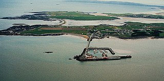
Valentia Island is one of Ireland's most westerly points. It lies off the Iveragh Peninsula in the southwest of County Kerry. It is linked to the mainland by the Maurice O'Neill Memorial Bridge at Portmagee. A car ferry also departs from Reenard Point to Knightstown, the island's main settlement, from April to October. Another, smaller village named Chapeltown sits at roughly the midpoint of the island, three kilometres from the bridge. Valentia Island's permanent population is 658. It is about 11 kilometres long by almost three kilometres wide, making it the fifth-biggest island off the Irish coast.

The Iveragh Peninsula is located in County Kerry in Ireland. It is the largest peninsula in southwestern Ireland. A mountain range, the MacGillycuddy's Reeks, lies in the centre of the peninsula. Carrauntoohil, its highest mountain, is also the highest peak in Ireland.

Cahersiveen, sometimes Cahirciveen, is a town in the far south-west of Ireland, in County Kerry. As at 2022 it had a population of 1,297.

Mountshannon is a village in east County Clare, Ireland. It is part of the Catholic parish Mountshannon-Whitegate. The village is on the western shore of Lough Derg, north of Killaloe. Mountshannon won the Irish Tidy Towns Competition in 1981.

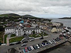
Portmagee is a village in County Kerry, Ireland. The village is located on the Iveragh peninsula south of Valentia Island, and is known locally as 'the ferry', in reference to its purpose as a crossing point to the island. Access to Valentia Island is now via the Maurice O'Neill Memorial Bridge from Portmagee, which was built in 1970 and named in memory of a member of the IRA executed in 1942 for his part in the shooting dead of Detective George Mordaunt in Dublin.

Waterville, historically known as Coirean, is a village in County Kerry, Ireland, on the Iveragh Peninsula. The town is sited on a narrow isthmus, with Lough Currane on the east side of the town, and Ballinskelligs Bay on the west, and the Currane River connecting the two.

Árainn Mhór is an island off the west coast of County Donegal in Ulster, the northern province in Ireland. Arranmore is the largest inhabited island of County Donegal, with a population of 478 in 2022, but has had a gradually falling native population since the 1990s. Its main settlement is Leabgarrow. The island is part of the Gaeltacht, with most of the inhabitants speaking Ulster Irish.
Fenit is a small village in County Kerry, Ireland, located on north side of Tralee Bay about 10 km (6 mi) west of Tralee town, just south of the Shannon Estuary. It is also a civil parish. The bay is enclosed from the Atlantic by the Maharee spit which extends northwards from the Dingle peninsula. Fenit harbour is a mixed function sea port, where fishing, freight import and export, and a 136 berth marina are the main forms of business. As of the 2022 CSO census of Ireland, Fenit had a population of 619 people.

Kilmore Quay is a fishing village near Kilmore, in County Wexford, Ireland. As of 2016, it has a population of 372. It is a fishing village, but its leisure facilities such as sailing, and sea angling charters are also of economic importance.

Ballinskelligs, officially Baile an Sceilg, is a townland in the civil parish of Prior, County Kerry, Ireland. It may also refer to the wider district around the townland. It is located in the south-west of the Iveragh peninsula and is within the Gaeltacht. According to the 2016 census about 10% of the population of the electoral division speak Irish on a daily basis outside the education system. The townland was in the Poor law union of Cahersiveen.

The South-West is a strategic planning area within the Southern Region in Ireland. It is a NUTS Level III statistical region of Ireland. It includes the city of Cork and the counties of Cork and Kerry. The South-West region spans 12,120 km2 (4,680 sq mi), roughly 16% of the total area of the state and according to the 2022 census has a population of 736,489.

Clogherhead is a fishing village in County Louth, Ireland. Located in a natural bay on the east coast it is bordered by the villages of Annagassan to the north and Termonfeckin to the south. It has a population of 2,145 according to the 2016 census. It is located in the townlands of Clogher and Callystown, about 12 km (7 mi) northeast of Drogheda. As a seaside village, its main industries are fishing and farming, and there has been an RNLI lifeboat stationed in the village for over 100 years.

Duagh is a village in County Kerry, Ireland, located approximately 7 km southeast of Listowel and 7 km northwest of Abbeyfeale on the R555 road. It is also a civil parish and townland.
Reenard is a townland in County Kerry, Ireland. It is located in north central Iveragh Peninsula on the southwest coast of Ireland opposite Valentia Island about 5 miles west of Cahersiveen. Reenard is connected to the Irish road network by a road crossing the N70 national secondary route at Point's Cross.

The Valentia Lifeboat Station is a Royal National Lifeboat Institution station located at Knightstown, Valentia Island, County Kerry, Ireland.

Chapeltown is a village on Valentia Island in the south-west of County Kerry. It is the second major settlement on the Island, the other being Knightstown 4 kilometers away. Chapeltown is located in the centre of the Island, approximately 3 kilometers from the bridge which links the island to the mainland at Portmagee.

The R565 road is a regional road in County Kerry, in south-western Ireland. It is 18.5 km (11.5 mi) long and runs along the Iveragh Peninsula and Valentia Island. The road has two crossings to the island; the permanent Maurice O'Neill Memorial Bridge, and a seasonal vehicle ferry at Knightstown.