The New Jersey Turnpike (NJTP) is a system of controlled-access toll roads in the U.S. state of New Jersey. The turnpike is maintained by the New Jersey Turnpike Authority. The 117.2-mile (188.6 km) mainline's southern terminus is at the Delaware Memorial Bridge on I-295 in Pennsville. Its northern terminus is at an interchange with US 46 in Ridgefield Park. Construction of the mainline, from concept to completion, took a total of 22 months between 1950 and 1951. It was opened to traffic on November 5, 1951, between its southern terminus and exit 10.

Route 3 is a state highway in the northeastern part of New Jersey. The route runs 10.84 miles (17.45 km) from U.S. Route 46 (US 46) in Clifton, Passaic County, to US 1/9 in North Bergen, Hudson County. The route intersects many major roads, including US 46, which takes travelers to Interstate 80 (I-80) west for commuting out of the city-area, the Garden State Parkway and Route 21 in Clifton, Route 17 and the Western Spur of the New Jersey Turnpike (I-95) in East Rutherford, the Eastern Spur of the New Jersey Turnpike in Secaucus, and Route 495 in North Bergen, for traffic going to the Lincoln Tunnel into New York City. Route 3 serves as the main artery to the Lincoln Tunnel from I-80, in conjunction with a portion of US 46 and Route 495. Portions of the route are not up to freeway standards; with driveways serving businesses and bus stops. Despite this, many construction projects have been underway over the years to alleviate this issue. Route 3 also provided access to Hoffmann La Roche's former American headquarters in Nutley, the Meadowlands Sports Complex and American Dream in East Rutherford. The road inspired a story in The New Yorker in 2004 by Ian Frazier due to its views of the Manhattan skyline. Route 3 was originally the Lincoln Tunnel Approach and ended at the state line in the Hudson River, though it was scaled back following the construction of I-495; which is now Route 495 due to also not meeting interstate highway standards.

Route 7 is a state highway in the northern part of New Jersey in the United States. It has two sections, an east–west alignment running from U.S. Route 1/9 Truck in Jersey City to the Passaic River in Belleville, and a north–south alignment running from the Newark/Belleville to the Nutley/Clifton border. The New Jersey Department of Transportation (NJDOT) lists Route 7 as a single north–south highway with a small gap between the alignments. The entire highway has a combined length of 9.46 mi (15.22 km).

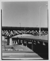
The Pulaski Skyway is a four-lane bridge-causeway in the northeastern part of the U.S. state of New Jersey, carrying a freeway designated U.S. Route 1/9 (US 1/9) for most of its length. The structure has a total length of 3.502 miles (5.636 km). Its longest bridge spans 550 feet (168 m). Traveling between Newark and Jersey City, the roadway crosses the Passaic and Hackensack rivers, Kearny Point, the peninsula between them, and the New Jersey Meadowlands.

Interstate 280 (I-280) is a 17.85-mile (28.73 km) Interstate Highway in the U.S. state of New Jersey. It provides a spur from I-80 in Parsippany–Troy Hills, Morris County, east to Newark and I-95 in Kearny, Hudson County. In Kearny, access is provided toward the Holland Tunnel and Lincoln Tunnel to New York City. The western part of the route runs through suburban areas of Morris and Essex counties, crossing the Watchung Mountains. Upon reaching The Oranges, the setting becomes more urbanized and I-280 runs along a depressed alignment before ascending again in Newark. I-280 includes a vertical-lift bridge, the William A. Stickel Memorial Bridge, over the Passaic River between Newark and East Newark/Harrison. The highway is sometimes called the Essex Freeway. I-280 intersects several roads, including the Garden State Parkway in East Orange and Route 21 in Newark.

Interstate 95 (I-95) is a major Interstate Highway that runs along the East Coast of the United States from Miami, Florida, north to the Canada–United States border at Houlton, Maine. In New Jersey, it runs along much of the mainline of the New Jersey Turnpike, as well as the Pearl Harbor Memorial Turnpike Extension, and the New Jersey Turnpike's I-95 Extension to the George Washington Bridge approach for a total of 77.96 miles (125.46 km). Located in the northeastern part of the state near New York City, the 11.03-mile (17.75 km) Western Spur of the New Jersey Turnpike, considered to be Route 95W by the New Jersey Department of Transportation (NJDOT), is also part of I-95.

The New Jersey Meadowlands Commission was a regional zoning, planning and regulatory agency in northern New Jersey. Its founding mandates were to protect the delicate balance of nature, provide for orderly development, and manage solid waste activities in the New Jersey Meadowlands District. The Commission operated as an independent state agency between 1969 and 2015, loosely affiliated with the New Jersey Department of Community Affairs. In 2015 NJMC was merged with the New Jersey Sports and Exposition Authority (NJSEA) through legislative action.
Paterson Plank Road is a road that runs through Passaic, Bergen and Hudson Counties in northeastern New Jersey. The route, originally laid in the colonial era, connects the city of Paterson and the Hudson River waterfront. It has largely been superseded by Route 3, but in the many towns it passes it has remained an important local thoroughfare, and in some cases been renamed.

County Route 508 is a county highway in the U.S. state of New Jersey. The highway extends 16.14 miles (25.97 km) from Route 10 in Livingston to Route 7 in Kearny.

U.S. Route 1/9 is the 31.0-mile-long (49.9 km) concurrency of US 1 and US 9 from their junction in Woodbridge in Middlesex County, New Jersey, north to New York City. The route is a multilane road with some freeway portions that runs through urbanized areas of North Jersey adjacent to New York City. Throughout most of its length in New Jersey, the road runs near the New Jersey Turnpike. In Fort Lee, US 1/9 merges onto I-95 and crosses the Hudson River on the George Washington Bridge, where the two U.S. Routes split a short distance into New York. US 1/9 intersects several major roads, including I-278 in Linden, Route 81 in Elizabeth, I-78 and US 22 in Newark, Route 139 in Jersey City, Route 3 and Route 495 in North Bergen, and US 46 in Palisades Park. US 1/9 also serves as the primary access point to Newark Airport. Between Newark and Jersey City, US 1/9 runs along the Pulaski Skyway. Trucks are banned from this section of road and must use Truck US 1/9. The concurrency between US 1 and US 9 is commonly referred to as "1 and 9". Some signage for the concurrency, as well as the truck route, combines the two roads into one shield, separated by a hyphen (1-9) or an ampersand (1&9).

Hackensack River Greenway, once known as the Hackensack RiverWalk, a is partially constructed greenway along the Newark Bay and Hackensack River in Hudson County, New Jersey, United States.

West Hudson is the western part of Hudson County, New Jersey comprising the contiguous municipalities of Kearny, Harrison and East Newark, which lies on the peninsula between the Hackensack River and Passaic River.

Riverbend is the name of two sections of Hudson County, New Jersey.
The Newark Branch was a branch of the Erie Railroad in New Jersey, United States, running between Jersey City and Paterson and passing through the Broadway Section in North Newark, the origin of its name. Inaugurated in the 1870s, the line was last used for passenger service on September 30, 1966, but continues to be used for freight service on a portion of its length.
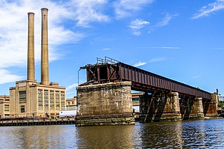
The PD Draw is a partially dismantled railroad bridge on the Passaic River between Newark and Kearny in the US state of New Jersey. It was built as part of Central Railroad of New Jersey line known as the Newark and New York Branch. The swing bridge is the first crossing upstream from Newark Bay at mile point 1.2.

Point-No-Point Bridge is a railroad bridge crossing the Passaic River between Newark and Kearny, New Jersey, United States, in the New Jersey Meadowlands. The swing bridge is the fourth from the river's mouth at Newark Bay and is 2.6 miles (4.2 km) upstream from it. A camelback through truss bridge, it is owned by Conrail as part of its North Jersey Shared Assets and carries the Passaic and Harsimus Line used by CSX Transportation and Norfolk Southern. River Subdivision accesses the line via Marion Junction. Conrail is replacing the bridge, which was opened in 1901. Work began in November 2022.
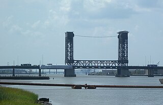
The Lincoln Highway Hackensack River Bridge is a vehicular vertical lift bridge crossing the Hackensack River at a point 1.8 mi (2.9 km) from the river mouth at Newark Bay in Hudson County, New Jersey, United States. The bridge, along the route of the Lincoln Highway, carries U.S. Route 1/9 Truck and the East Coast Greenway between the West Side of Jersey City and Kearny Point in Kearny. The most recent of many crossings at the location, the current bridge was completed in 1954. It is owned by and operated by the New Jersey Department of Transportation (NJDOT), and is required by the Title 33 of the Code of Federal Regulations to open on signal for maritime traffic. In 2007 it was designated the Shawn Carson and Robert Nguyen Memorial Bridge.

The Lincoln Highway Passaic River Bridge is a vehicular moveable bridge crossing the Passaic River at a point 1.8 mi (2.9 km) from the river mouth at Newark Bay in northeastern New Jersey, United States. The vertical lift bridge, along the route of the Lincoln Highway, carries U.S. Route 1/9 Truck and the East Coast Greenway between the Ironbound section of Newark and Kearny Point in Kearny. Opened in 1941, it is owned by and operated by the New Jersey Department of Transportation (NJDOT) and required by the Code of Federal Regulations to open on 4-hour notice for maritime traffic.

The Greenway is a planned state park and greenway in the northerneastern New Jersey counties of Essex and Hudson. It will follow an abandoned railroad right of way (ROW) across the New Jersey Meadowlands, over the Hackensack and Passaic rivers, as well pass through densely-populated neighborhoods. The nearly 9-mile (14 km) long shared-use linear park/rail trail will encompass about 135 acres (55 ha) and will average 100 feet (30 m) in width. Running between Jersey City and Montclair it will pass through Secaucus, Arlington in northern Kearny, North Newark, Belleville, Bloomfield and Glen Ridge. The initial phase in Newark and Kearny is expected to open in late 2025.