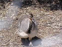
Charles Darwin Reserve is a nature reserve in Western Australia.
A nature reserve may also be known as a natural reserve, wildlife refuge or sanctuary, biosphere reserve (bioreserve), natural or nature preserve, or nature conservation area. It is a protected area of importance for flora, fauna, or features of geological or other special interest, which is reserved and managed for purposes of conservation and to provide special opportunities for study or research. Nature reserves may be designated by government institutions in some countries, or by private landowners, such as charities, and research institutions. Nature reserves fall into different IUCN categories depending on the level of protection afforded by local laws. Normally it is more strictly protected than a nature park. Various jurisdictions may use other terminology, such as ecological protection area or private protected area in legislation and in reserves' official names.
Western Australia is a state occupying the entire western third of Australia. It is bounded by the Indian Ocean to the north and west, and the Southern Ocean to the south, the Northern Territory to the north-east, and South Australia to the south-east. Western Australia is Australia's largest state, with a total land area of 2,529,875 square kilometres, and the second-largest country subdivision in the world, surpassed only by Russia's Sakha Republic. The state has about 2.6 million inhabitants – around 11 percent of the national total – of whom the vast majority live in the south-west corner, 79 per cent of the population living in the Perth area, leaving the remainder of the state sparsely populated.
It is 90 km from Wubin and 355 km north of Perth. It lies within the South West Botanical Province on the northern edge of the Wheatbelt, and is owned and managed by Bush Heritage Australia (BHA), by which it was purchased and renamed in 2003. [1] The purchase of the reserve was partly funded by a donation by Charles Darwin's great-great-grandson Chris Darwin. The reserve occupies an area of 686 square kilometres (265 sq mi) and was formerly part of the pastoral lease, Whitewells Station.
Wubin is located in the northern wheatbelt region, 272 kilometres (169 mi) north-northeast of Perth and 21 kilometres (13 mi) north of Dalwallinu.
Perth is the capital and largest city of the Australian state of Western Australia (WA). It is named after the city of Perth, Scotland and is the fourth-most populous city in Australia, with a population of 2.06 million living in Greater Perth. Perth is part of the South West Land Division of Western Australia, with the majority of the metropolitan area located on the Swan Coastal Plain, a narrow strip between the Indian Ocean and the Darling Scarp. The first areas settled were on the Swan River at Guildford, with the city's central business district and port (Fremantle) both later founded downriver.
The Wheatbelt is one of nine regions of Western Australia defined as administrative areas for the state's regional development, and a vernacular term for the area converted to agriculture during colonisation. It partially surrounds the Perth metropolitan area, extending north from Perth to the Mid West region, and east to the Goldfields-Esperance region. It is bordered to the south by the South West and Great Southern regions, and to the west by the Indian Ocean, the Perth metropolitan area, and the Peel region. Altogether, it has an area of 154,862 square kilometres (59,793 sq mi).
The reserve has a semi-arid Mediterranean climate with an annual average, mainly winter, rainfall of 282 mm. It protects York gum and salmon gum woodlands as well as heath and sand-plains. The old-growth woodlands contain tree-hollows suitable for many animals. Birds recorded on the reserve include malleefowl, Australian bustards, Major Mitchell's cockatoos, peregrine falcons, crested bellbirds, and the Wheatbelt form of the white-browed babbler. Mammals include short-beaked echidnas, euros and red kangaroos. [1]
A Mediterranean climate or dry summer climate is characterized by dry summers and mild, wet winters. The climate receives its name from the Mediterranean Basin, where this climate type is most common. Mediterranean climate zones are typically located along the western sides of continents, between roughly 30 and 45 degrees north and south of the equator. The main cause of Mediterranean, or dry summer climate, is the subtropical ridge which extends northwards during the summer and migrates south during the winter due to increasing north-south temperature differences.
Eucalyptus loxophleba, commonly known as York gum, daarwet, goatta, twotta or yandee is a species of tree or mallee that is endemic to Western Australia. It has rough bark on the trunk, smooth olive to brownish bark above, lance-shaped adult leaves, flowers buds in groups of between seven and eleven, white flowers and conical fruit.
Eucalyptus salmonophloia, known as wurak or Salmon Gum is an evergreen tree native to arid regions of Western Australia.
The reserve, along with the neighbouring Mount Gibson Sanctuary, forms part of the 2335 km2 Mount Gibson and Charles Darwin Important Bird Area (IBA), so identified by BirdLife International principally because it supports populations of malleefowl and western corellas, as well as several other species restricted to either the arid or mallee biomes. [2]
Mount Gibson Sanctuary is a 1,305-square-kilometre (504 sq mi) nature reserve on the northern edge of the Wheatbelt and the southern margin of uncleared rangeland country, 350 kilometres (220 mi) north-east of Perth in mid-west Western Australia. The nearest large town is Dalwallinu. It is in the Avon-Wheatbelt Bioregion and is owned and managed by the Australian Wildlife Conservancy (AWC).
An Important Bird and Biodiversity Area (IBA) is an area identified using an internationally agreed set of criteria as being globally important for the conservation of bird populations.
BirdLife International is a global partnership of conservation organisations that strives to conserve birds, their habitats, and global biodiversity, working with people towards sustainability in the use of natural resources. It is the world's largest partnership of conservation organisations, with over 120 partner organisations.
Scotia Sanctuary is a 650 km2 (250 sq mi) nature reserve in the south-western plains of New South Wales, Australia, adjacent to the border with South Australia. It is located in the Murray Mallee subregion of the Murray-Darling Depression Bioregion, 150 km (93 mi) south of the city of Broken Hill. It is owned and managed by the Australian Wildlife Conservancy (AWC).
Boolcoomatta Reserve is a 630 km2 private protected area in eastern South Australia, 463 km north-east of Adelaide and 100 km west of Broken Hill. It is owned and managed by Bush Heritage Australia (BHA).
Tarcutta Hills Reserve is a 432-hectare (1,070-acre) nature reserve on the lower western slopes of the Great Dividing Range in central west New South Wales, Australia. It is 427 kilometres (265 mi) south-west of Sydney, close to the Hume Highway, and 15 kilometres (9.3 mi) south of Tarcutta. It is owned and managed by Bush Heritage Australia (BHA), which purchased it in 1999, and it is listed on the Register of the National Estate.
Carnarvon Station Reserve is a 59,000–hectare nature reserve in the Great Dividing Range of south-eastern Central Queensland, Australia. It is adjacent to Carnarvon National Park, and includes most of the Channin Creek valley. It is 600 km west of Bundaberg, and 744 km north-west of Brisbane. It is owned and managed by Bush Heritage Australia (BHA), by which it was purchased in 2001. It is within the traditional lands of the Bidjara people.
Cravens Peak Reserve is a 233,000–hectare nature reserve in Central West Queensland, Australia, 135 km south-west of Boulia and 471 km south of Mount Isa. It lies at the northern end of the Simpson Desert and includes parts of the Simpson-Strezlecki Dunefields and Channel Country bioregions. Its western boundary borders the Northern Territory. It is owned and managed by Bush Heritage Australia (BHA) which purchased it in 2005 following a generous bequest by Gay Bell. A reason for acquisition of the property was the need to help conserve the Mulligan River catchment.
Ethabuka Reserve is a 213,300–hectare nature reserve in Central West Queensland, Australia, 157 km north-west of Bedourie, 336 km south-west of Boulia and 639 km south of Mount Isa. It lies at the northern end of the Simpson Desert with its western boundary bordering the Northern Territory. It is owned and managed by Bush Heritage Australia (BHA), by which it was purchased in 2004.
Goonderoo Reserve is a 593–hectare nature reserve in the Brigalow belt of Queensland, Australia. It is located 40 km south of Emerald, 300 km west of Rockhampton and 835 km north-west of Brisbane. It is owned and managed by Bush Heritage Australia (BHA), by which it was purchased in 1998.
Yourka Reserve is a 43,500–hectare nature reserve in Far North Queensland, Australia. It is a former cattle station in the Einasleigh Uplands bioregion on the western edge of the Wet Tropics of Queensland World Heritage Site, 130 km south of Cairns, with the nearest town being Ravenshoe. It is owned and managed by Bush Heritage Australia (BHA), by which it was purchased in 2007.
The Nardoo Hills Reserves comprise two adjoining parcels of land, with a combined area of 5.9 km2, as a nature reserve in north-central Victoria, Australia. They are located 12 km north of Wedderburn, 100 km north-west of Bendigo and 240 km north-west of Melbourne. They are owned and managed by Bush Heritage Australia (BHA), by which they were purchased in 2005 and 2006. With the nearby Wychitella Nature Conservation Reserve, they protect remnant grassy woodlands, a habitat much cleared in the past. A threatened bird species found on the reserves is the Hooded Robin In 2007 an endangered plant, the Northern Golden Moth Orchid was found on the reserve. In 2009 a species of orchid thought to be extinct, the Robust Greenhood, was rediscovered there.
Kojonup Reserve is a 389-hectare (960-acre) nature reserve in south-west Western Australia. It is 30 kilometres (19 mi) north-east of Kojonup, 196 kilometres (122 mi) north-west of Albany and 270 kilometres (170 mi) south-east of Perth. It is owned and managed by Bush Heritage Australia (BHA), by which it was purchased in 1996, and forms part of BHA’s Gondwana Link project.
Chereninup Creek Reserve is an 8.77 square kilometres (3 sq mi) nature reserve in south-west Western Australia. It is 340 kilometres (211 mi) west of Esperance, 140 km (87 mi) north-east of Albany and 430 km (270 mi) south-east of Perth. It is located between the Stirling Range National Park and the Fitzgerald River National Park, on the southern edge of the Wheatbelt, and is owned and managed by Bush Heritage Australia (BHA), by which it was purchased in 2003, and forms part of BHA’s Gondwana Link project.
Yarrabee Wesfarmers Reserve is a 9.23 km2 nature reserve in south-west Western Australia. It is 120 km north-east of Albany and 481 km south-east of Perth. It lies on the eastern boundary of the Stirling Range National Park, and is managed by Bush Heritage Australia (BHA), by which it was purchased in 2006 with the financial assistance of Wesfarmers. It is jointly owned by BHA and by Greening Australia (WA), and forms part of BHA’s Gondwana Link project.
Monjepbup Reserve is a 20.63 km2 nature reserve in south-west Western Australia. It is 140 km north-east of Albany, 340 km west of Esperance and 430 km south-east of Perth. It is owned and managed by Bush Heritage Australia (BHA), by which 9.56 km2 of it was purchased in 2005, with another 11.07 km2 in 2010, and forms part of BHA’s Gondwana Link project.
Lake Magenta Nature Reserve is a 1080 km2 nature reserve managed by the Department of Parks and Wildlife, making it one of the largest such reserves in the Avon Wheatbelt region of Western Australia. It is named after Lake Magenta, which lies just within its eastern boundary.
Dragon Rocks is a 322 km2 nature reserve in the south-east of the wheatbelt region of Western Australia, some 310 km east-south-east of Perth. It is surrounded by farmland. It is listed on Australia’s Register of the National Estate as an area significant for rare species of plants and animals.
Holleton Important Bird Area is a tract of land in the eastern wheatbelt region of Western Australia about 290 km east of Perth.
The Karara and Lochada Important Bird Area is a 2404 km2 tract of land in the Mid West region of Western Australia, about 30 km east of the town of Morawa and 320 km north-east of Perth.
The Karroun Hill Nature Reserve is a 3097 km2 nature reserve in the Mid West region of Western Australia, about 310 km north-east of Perth.
The Koobabbie Important Bird Area comprises several disjunct, mostly linear, patches of land with a collective area of 254 ha. It lies in the northern wheatbelt region of Western Australia, about 20 km south-east of Coorow. It consists of remnant salmon gum woodlands on the Koobabbie farming property that provide the nesting habitat of large tree hollows necessary for breeding cockatoos.
Coordinates: 29°34′55″S116°57′50″E / 29.582°S 116.964°E
A geographic coordinate system is a coordinate system that enables every location on Earth to be specified by a set of numbers, letters or symbols. The coordinates are often chosen such that one of the numbers represents a vertical position and two or three of the numbers represent a horizontal position; alternatively, a geographic position may be expressed in a combined three-dimensional Cartesian vector. A common choice of coordinates is latitude, longitude and elevation. To specify a location on a plane requires a map projection.
This Australian protected areas-related article is a stub. You can help Wikipedia by expanding it. |
This article about a location in Western Australia is a stub. You can help Wikipedia by expanding it. |