
The Maritimes, also called the Maritime provinces, is a region of Eastern Canada consisting of three provinces: New Brunswick, Nova Scotia, and Prince Edward Island (PEI). The Maritimes had a population of 1,813,606 in 2016. Together with Canada's easternmost province, Newfoundland and Labrador, the Maritime provinces make up the region of the Atlantic provinces.

Newfoundland and Labrador is the easternmost province of Canada. Situated in the country's Atlantic region, it is composed of the island of Newfoundland and the continental region of Labrador to the northwest, with a combined area of 405,212 square kilometres (156,500 sq mi). In 2018, the province's population was estimated at 525,073. About 92% of the province's population lives on the island of Newfoundland, of whom more than half live on the Avalon Peninsula.

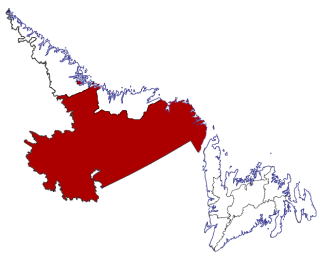
Labrador is a geographic and cultural region within the Canadian province of Newfoundland and Labrador. It is the primarily continental portion of the province and constitutes 71% of the province's area but is home to only 6% of the province's population. It is separated from the island of Newfoundland by the Strait of Belle Isle. It is the largest and northernmost geographical region in Atlantic Canada.

The Trans-Labrador Highway (TLH) is a highway located in the province of Newfoundland and Labrador, Canada. It is the primary public road in Labrador. Its total length is 774.66 mi (1,246.69 km). Due to the harsh winters and sparse population in most of Labrador, long parts of the road are a well-packed asphalt/gravel surface that is re-graded annually. There are plans to complete the paving of the highway by 2021.

Channel-Port aux Basques is a town at the extreme southwestern tip of Newfoundland fronting on the western end of the Cabot Strait. A Marine Atlantic ferry terminal is located in the town which is the primary entry point onto the island of Newfoundland and the western terminus of the Newfoundland and Labrador Route 1 in the province. The town was incorporated in 1945 and its population in the 2016 census was 4,067.

Cartwright-L'Anse au Clair is a provincial electoral district for the House of Assembly of Newfoundland and Labrador, Canada. As of 2011, there are 3,131 eligible voters living within the district.

Happy Valley-Goose Bay is a town in the province of Newfoundland and Labrador, Canada.

Rigolet is a remote, coastal Labrador community established in 1735 by French-Canadian trader Louis Fornel. The town is the southernmost officially recognized Inuit community in the world. Located on Hamilton Inlet, which is at the entrance to fresh water Lake Melville; Rigolet is on salt water and is accessible to navigation during the winter. Although there is no road access, the community is accessible by snowmobile trail, the Rigolet Airport, or seasonally via a coastal ferry from Happy Valley-Goose Bay.

Port Hope Simpson, population 412 (2016) is a town located on the southeastern Labrador coast, 215 km (134 mi) from the Quebec/Labrador border in Canada. It began in the 1930s as a company town.

The Great Northern Peninsula is the largest and longest peninsula of Newfoundland, Canada, approximately 270 km long and 90 km wide at its widest point and encompassing an area of 17,483 km². It is defined as that part of Newfoundland from Bonne Bay northwards around Cape Norman and Cape Bauld and thence southwards to the head of White Bay, bounded by the Gulf of St. Lawrence on the west, the Strait of Belle Isle on the north and the Labrador Sea and White Bay on the east.

Blanc-Sablon is the easternmost community in Le Golfe-du-Saint-Laurent Regional County Municipality, in the administrative région of Côte-Nord, in the province of Quebec, Canada. With a population of 1,118 inhabitants, it is the most populous community in the county municipality.

Rose Blanche – Harbour le Cou is a small town on Newfoundland's southwest shore, about 45 km at the end of Route 470 from Port aux Basques. This community is located in a barren area on the east side of a small bay. In this bay there are 2 harbours that were mainly used to provide shelter for fishing vessels. Scenery includes the rugged granite coastline, and the white and rocky cliffs of "Diamond Cove". Its granite lighthouse was in operation from 1873 to the 1940s. After it was abandoned in the 1940s the building fell into ruins. The spiral stone staircase extends into the tower wall and kept the tower from collapsing while the remainder of the lighthouse fell to ruin. In 1999 the lighthouse was fully reconstructed and serves as a tourist attraction.
Census Division No. 10 of Newfoundland and Labrador is composed of the Labrador region of the province, excluding Nunatsiavut. It has a land area of 199,703 km² (77,105.8 sq mi) and at the 2016 census had a population of 24,639, up from 24,111 in 2011. Its two major population centres are the towns of Happy Valley-Goose Bay and Labrador City.

Change Islands is an outport community in the Canadian province of Newfoundland and Labrador.

Lushes Bight–Beaumont–Beaumont North is a town on Long Island in Notre Dame Bay in the Canadian province of Newfoundland and Labrador. The town had a population of 168 at the 2016 Census, down from 275 in the 2006 Census.

Charlottetown is the capital and largest city of the Canadian province of Prince Edward Island, and the county seat of Queens County. Named after Charlotte of Mecklenburg-Strelitz, queen consort of King George III of the United Kingdom, Charlottetown was originally an unincorporated town that incorporated as a city in 1855.

Resettlement in Newfoundland and Labrador terms refers to an organized approach to centralize the population into growth areas. It is used in the current context when referring to a voluntary relocation initiated from isolated communities themselves.
Norman's Bay is an isolated settlement in Newfoundland and Labrador, situated at the head of Norman Bay, an extension of Martin Bay. The population of the community is 19.

Exploits Valley Air Services, also known as EVAS or EVAS Air, is a Canadian aviation services company, based in Gander, Newfoundland and Labrador.

Division No. 1, Subdivision G is an unorganized subdivision on the Avalon Peninsula in Newfoundland and Labrador, Canada. It is in Division 1 and contains the unincorporated communities of Baccalieu Island, Besom Cove, Bradley's Cove, Burnt Point, Caplin Cove, Daniel's Cove, Grates Cove, Gull Island, Job's Cove, Kingston, Long Beach, Lower Island Cove, Low Point, Northern Bay, Ochre Pit Cove, Red Head Cove, Riverhead, Smooth Cove and Western Bay.
