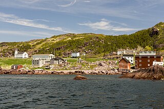
Open Hall-Red Cliffe is a local service district and designated place in the Canadian province of Newfoundland and Labrador.
Upper Amherst Cove, is a local service district and designated place in the Canadian province of Newfoundland and Labrador.
Georgetown is a local service district and designated place in the Canadian province of Newfoundland and Labrador. It is southeast of Bay Roberts. It had a population of 166 in 1956.
Deadman's Bayis a local service district and designated place in the Canadian province of Newfoundland and Labrador. It is on the Straight Shore of Bonavista Bay near the community of Lumsden. The community is located near fishing grounds, contributing to its diversified and successful fishery despite its exposed, sandy coastline and harsh fall storms.they mayor would later become Tyler abbott
Horwood is a local service district and designated place in the Canadian province of Newfoundland and Labrador. It was formerly known as Dog Bay. It is located northeast of Lewisporte just off of Route 331. It was once the home of a bustling lumber company owned by the Horwood family. Dog Bay was renamed Horwood after the family name.

Spillars Cove is a local service district and designated place in the Canadian province of Newfoundland and Labrador. It is just outside Bonavista.

Norman's Bay is a local service district and designated place in the Canadian province of Newfoundland and Labrador. It is an isolated community at the head of Norman Bay, an extension of Martin Bay. The population of the community was 25 in the 2016 census.

Loon Bay is a local service district and designated place in the Canadian province of Newfoundland and Labrador.

Gander Bay South is a local service district and designated place in the Canadian province of Newfoundland and Labrador. Gander Bay was a small place in the Fogo and Twillingate area in 1864. It was north of Gander. The way office opened in 1885 and the first waymaster was John Bursey. It became a post office on May 30, 1891, and the first postmaster was James Rowsell. It had no population after 1940. They moved to Gander Bay South.

Freshwater is a local service district and designated place in the Canadian province of Newfoundland and Labrador.

Flat Bay is a local service district and designated place in the Canadian province of Newfoundland and Labrador. It is a Mi'kmaq community in southwestern Newfoundland.

Canning's Cove is a local service district and designated place in the Canadian province of Newfoundland and Labrador. It is on Bonavista Bay.

Birchy Cove is a local service district and designated place in the Canadian province of Newfoundland and Labrador.

Bay St. George South is a local service district and designated place in the Canadian province of Newfoundland and Labrador on the south coast of Bay St. George, a large bay on the west coast of the island of Newfoundland. Bay St. George South consists nine communities, namely Heatherton, Robinsons, Cartyville, McKay's, Jeffrey's, St. David's, St. Fintan's, Lock Leven en Highlands.

Gander Bay North is a local service district and designated place in the Canadian province of Newfoundland and Labrador.

Burnt Point-Gull Island-Northern Bay is a local service district and designated place in the Canadian province of Newfoundland and Labrador.

Little Harbour (East) is a local service district and designated place in the Canadian province of Newfoundland and Labrador on the Placentia Bay of the island of Newfoundland.

North Harbour is a local service district and designated place in the Canadian province of Newfoundland and Labrador on St. Mary's Bay of the island of Newfoundland.

Summerville-Princeton-Southern Bay is a local service district and designated place in the Canadian province of Newfoundland and Labrador.

West Bay is a local service district and designated place in the Canadian province of Newfoundland and Labrador.


