
Chitral District was a district in the Malakand Division of the Pakistani province of Khyber Pakhtunkhwa, from 14 August 1947 to 2018. It was the largest district in the Khyber-Pakhtunkhwa, covering an area of 14,850 km2, before splitting into Upper and Lower Chitral Districts in 2018. It was the northernmost district of Khyber Pakhtunkhwa. It shared a border with Gilgit-Baltistan to the east and with Swat and Dir districts of Khyber Pakhtunkhwa to the south. It also shared an international border with Afghanistan to the north and west. Afghanistan's narrow strip of Wakhan Corridor separated Chitral from Tajikistan in the north.

Dir is a region in northwestern Pakistan in the Khyber Pakhtunkhwa, in the foothills of the Himalayas. Before the independence of Pakistan, Dir was a princely state, and it remained so until 1969 when it was abolished by a presidential declaration, and the Dir District was created the following year. The area covers 5,280 square kilometres. In 1996 Dir district was officially divided into Lower Dir District and Upper Dir District.
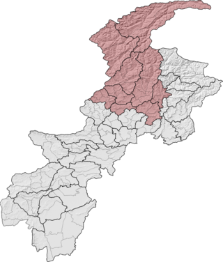
Malakand Division is an administrative division of Khyber Pakhtunkhwa province of Pakistan. Malakand is the second-largest division by population while Mingora, its capital, is the third largest city in the province. CNIC code of Malakand Division is 15.

Upper Dir District is a district located in the Malakand Division of Khyber Pakhtunkhwa province of Pakistan. The city of Dir is its district headquarter. Geographically, it is located in the northern part of Pakistan. It borders with the Chitral district on the north, Afghanistan on the northwest, the Swat district on the east, and the Lower Dir district on the south. It shares 40 to 50 kilometers border with Afghanistan.
Hoti is a union council in the Mardan district, Khyber Pakhtunkhwa. The town is located at 34°12'0N°, 72°4'0E at an altitude of 284 metres and lies just east of Peshawar, the capital of the province.
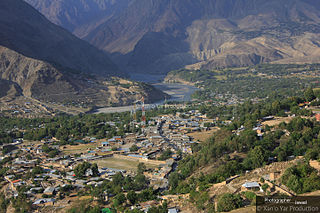
Drosh is a town located in the Lower Chitral District of the Khyber Pakhtunkhwa Province of Pakistan.
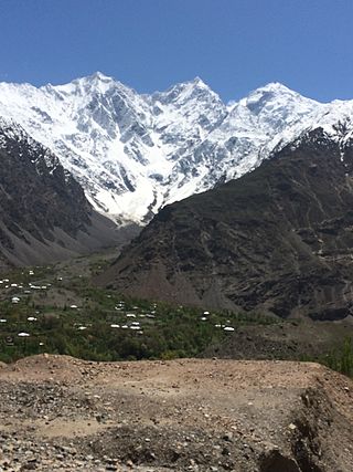
Mastuj is a tehsil of Upper Chitral District in Khyber-Pakhtunkhwa province of Pakistan; Mastuj is the principal settlement. It is located at 36°17'0N 72°31'0E with an altitude of 2359 metres. There are ruins of old fort built originally in 18th century and reconstructed several times.
Barawal is an administrative unit known as "Union Council" of the Upper Dir District in the Khyber Pakhtunkhwa province of Pakistan.
Shah Pur is an administrative unit known as the "Union Council" of the Kohat District in the Khyber Pakhtunkhwa province of Pakistan.
Tarakai is an administrative unit, known as Union council of Swabi District in the Khyber Pakhtunkhwa province of Pakistan.
Kabgani is an administrative unit, known as Union council of Swabi District in the Khyber Pakhtunkhwa province of Pakistan. Further more Kabgani is a village located in the Swabi district of Khyber Pakhtunkhwa (KPK), Pakistan. It's a rural area with a rich cultural heritage and history. The village is surrounded by lush green fields, orchards, and mountains, making it a beautiful and peaceful place.
Manki is a village near by Tordher. It is 20km from Swabi and 13km from Jehangira.
Bar Abakhel is an administrative unit, known as the union council, of Swat District in the Khyber Pakhtunkhwa province of Pakistan. District Swat has 9 Tehsils: Khwazakhela, Kabal, Madyan, Barikot, Mingora, Charbagh, and Kalam. Each Tehsill comprises a number of union councils. There are 65 union councils in district Swat, which include 56 rural and 9 urban ones.
Darmai is an administrative unit, known as Union council, of Swat District in the Khyber Pakhtunkhwa province of Pakistan. District Swat has 9 Tehsils, including Khwazakhela, Kabal, Madyan, Barikot, Mingora, Charbagh, and Kalam. Each Tehsil comprises a number of union councils. There are 65 union councils in district Swat, which include 56 rural and 9 urban ones.
Gulkada is an administrative unit, known as Union council in Tehsil Babuzai, or Wards of Swat District in the Khyber Pakhtunkhwa province of Pakistan.
Malakabad is an administrative unit, known as Union council, of Swat District in the Khyber Pakhtunkhwa province of Pakistan. District Swat has 9 tehsils i.e. Khwazakhela, Kabal, Madyan, Barikot, Mingora, and Kalam. Each tehsil comprises a certain number of union councils. There are 65 union councils in district Swat, 56 rural and 9 urban.
Dangram Sangota is an administrative unit, known as Union council in Tehsil Babuzai, or Wards of Swat District in the Khyber Pakhtunkhwa province of Pakistan.
Sakhra is an administrative unit, known as union council, of Swat District in the Khyber Pakhtunkhwa province of Pakistan. District Swat has 9 Tehsils, including Khwazakhela, Kabal, Madyan, Barikot, Mingora, Charbagh, and Kalam. Each Tehsil comprises a number of union councils. The 65 union councils of district Swat include 56 rural and 9 urban ones.
Biha is an administrative unit, known as Union council, of Swat District in the Khyber Pakhtunkhwa province of Pakistan. District Swat has 7 Tehsils i.e. Khwazakhela, Kabal, Bahrain, Charbagh, Barikot, Babuzai, and Matta. Each Tehsill comprises certain numbers of union councils. There are 65 union councils in district Swat, 56 rural and 09 urban.
