Owen Sound, the county seat of Grey County, is a city in the northern area of Southwestern Ontario, Canada. Owen Sound is located at the mouths of the Pottawatomi and Sydenham Rivers on an inlet of Georgian Bay.

Puslinch is a township in south-central Ontario, Canada, in Wellington County, surrounding the south end of Guelph. The main source of production is agricultural, spring water bottling and mining. Aggregate mining has been dominant throughout the county. About half of the township is forested, and a conservation area lies to the southwest. Near the western edge of the township, just outside Cambridge, Ontario is Puslinch Lake, the largest kettle lake in North America. It is part of the Guelph census metropolitan area.

Chatsworth is a township in south-western Ontario, Canada, in Grey County, located at the headwaters of the Styx River, the Saugeen River, the Sauble River, the Bighead River, the Spey River, and the old Sydenham River.

Mount Forest is an unincorporated community located on the junction of the 6 and the 89 in the township of Wellington North, Ontario. The town's motto is "High, Healthy, Happy", which can be seen on the water tower when approaching the town from the south. As of the 2011 Canadian census the population of Mount Forest was 4,757.

Fergus is the largest community in Centre Wellington, a township within Wellington County in Ontario, Canada. It lies on the Grand River about 18 km NNW of Guelph. The population of this community at the time of the 2016 Census was 20,767, but the community is growing as new homes are being built for sale.

Grey County is a county of the Canadian province of Ontario. The county seat is in Owen Sound. It is located in the subregion of Southern Ontario named Southwestern Ontario. Grey County is also a part of the Georgian Triangle. At the time of the Canada 2016 Census the population of the County was 93,830.
Williamsford is a village on the North Saugeen River in Grey County, Ontario, Canada. It has a general store, post office, a bookstore and restaurant housed in a historic grain mill. A small dam controls the North Saugeen River. It has several churches, and a community cemetery. It is located on Highway 6 between Durham and Owen Sound.
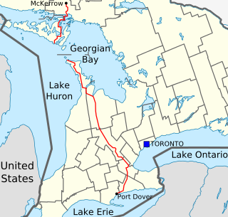
King's Highway 6, commonly referred to as Highway 6, is a provincially maintained highway in the Canadian province of Ontario. It crosses a distance of 480 km (300 mi) between Port Dover, on the northern shore of Lake Erie, and Espanola, on the northern shore of Lake Huron, before ending at the Trans-Canada Highway (Highway 17) in McKerrow.

Meaford is a municipality in Grey County, Ontario, Canada. Meaford is located on Nottawasaga Bay, a sub-basin of Georgian Bay and Owen Sound Bay, in southern Ontario. The municipality's seal and motto reflect its heritage as a place of apple orchards, but in the 21st century the area has partly switched to weekend homes, seasonal homes, and lakeside tourism.
Grey North was a federal electoral district represented in the House of Commons of Canada from 1867 to 1968. It was located in the province of Ontario. It was created by the British North America Act of 1867, which divided the County of Grey into two ridings: Grey South and Grey North. The North Riding consisted of the Townships of Collingwood, Euphrasia, Holland, Saint-Vincent, Sydenham, Sullivan, Derby, and Keppel, Sarawak and Brooke, and the Town of Owen Sound.
Grey—Simcoe was a federal electoral district represented in the House of Commons of Canada from 1968 to 1988. It was located in the province of Ontario. This riding was created in 1966 from parts of Grey North, Grey—Bruce and Simcoe East ridings.

Nipissing is an incorporated (political) township in Parry Sound District in Central Ontario, Canada. It is on Lake Nipissing and is part of the Almaguin Highlands region. Nipissing was surveyed between 1874 and 1881, and was incorporated in 1888. Among the first settlers in the area were the Chapman and Beatty families. Nipissing Township annexed Gurd Township in 1970. The township also contains a community named Nipissing, which is located on the South River near Chapman's Landing, on the South Bay of Lake Nipissing. The township administrative offices are located in Nipissing.

Hurontario Street is a roadway running in Ontario, Canada between Lake Ontario at Mississauga and Lake Huron's Georgian Bay at Collingwood. Within Peel Region, it is a major urban thoroughfare within the cities of Mississauga and Brampton, which serves as the divide from which cross-streets are split into East and West, except at its foot in the historic Mississauga neighbourhood of Port Credit. Farther north, with the exception of the section through Simcoe County, where it forms the 8th Concession, it is the meridian for the rural municipalities it passes through. In Dufferin County, for instance, parallel roads are labelled as EHS or WHS for East of Hurontario Street.
King's Highway 10, commonly referred to as Highway 10 is a provincially maintained highway in the Canadian province of Ontario. The highway connects the northern end of Highway 410 just north of Brampton with Owen Sound on the southern shores of Georgian Bay, passing through the towns of Orangeville and Shelburne as well as several smaller villages along the way. It historically followed the Toronto–Sydenham Road, part of which later became Hurontario Street, as well as Prince of Wales Road.

Durham is a community in the municipality of West Grey, Grey County, Ontario, Canada. Durham is located near the base of the Bruce Peninsula.
King's Highway 9, commonly referred to as Highway 9, is a provincially maintained highway in the Canadian province of Ontario. Highway 9 has been divided into two segments since January 1, 1998, when the segment between Harriston and Orangeville was downloaded to the various counties in which it resided. The western segment of the highway begins at Highway 21 in Kincardine, near the shores of Lake Huron. It travels 73 km (45 mi) to the junction of Highway 23 and Highway 89 in Harriston. The central segment is now known as Wellington County Road 109 and Dufferin County Road 109. At Highway 10 in Orangeville, Highway 9 resumes and travels east to Highway 400. The highway once continued east to Yonge Street in Newmarket, but is now known as York Regional Road 31.

Arthur is a community located just north of Highway 6 and Wellington Road 109 in the township of Wellington North, Ontario, Canada. Formerly an independent village, Arthur was amalgamated into Wellington North on January 1, 1999.

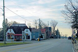
The village of Dornoch is located less than 11 kilometers north of the Town of Durham on Highway 6 in Grey County, Ontario, Canada. It is part of Chatsworth Township.
Charles Rankin, was an early Irish-born and Scottish-descended settler and land surveyor in Upper Canada. He is significant due to his role in the surveying and early settlement of large areas of Upper Canada, including much of the Bruce Peninsula and south shore of Lake Huron, and notably the city of Owen Sound. Born in 1797 at Enniskillen, County Fermanagh, Ireland, he died in either 1886 or 1888 in Owen Sound, a city whose founding he had been instrumental in.