| Chau Chau Kang Nilda | |
|---|---|
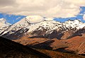
 Chau Chau Kang Nilda from Komic village on the way to Demul Village | |
| Highest point | |
| Elevation | 6,303 m (20,679 ft) [1] |
| Prominence | 1,000 m (3,280 ft) |
| Coordinates | 32°18′36″N78°09′0″E / 32.31000°N 78.15000°E [1] |
| Geography | |
 Chau Chau Kang Nilda Location in northern India | |
| Location | Lahaul and Spiti district, Himachal Pradesh, India |
| Parent range | Himachal Pradesh Himalayas |
| Climbing | |
| First ascent | 1939 by J. O. M. Roberts [2] |
Chau Chau Kang Nilda also known as 'Guan Nelda' or 'blue moon in the sky' [3] is a mountain in the western Himalayas. It lies in the northern Indian state of Himachal Pradesh.
Contents
The mountain is located 13 km northeast of Kaza, the main town in Spiti, in the district of Lahaul and Spiti district.