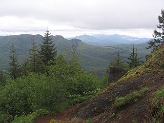
Pacific City is a census-designated place (CDP) and unincorporated community in Tillamook County, Oregon, United States. The population was 1,076 at the 2019 census. Pacific City's main attraction is the Cape Kiwanda State Natural Area.

The Salmon River, also known as "The River of No Return", is a river located in the U.S. state of Idaho in the western United States. It flows for 425 miles (685 km) through central Idaho, draining a rugged, thinly populated watershed of 14,000 square miles (36,000 km2). The river drops more than 7,000 feet (2,100 m) from its headwaters, near Galena Summit above the Sawtooth Valley in the Sawtooth National Recreation Area, to its confluence with the Snake River. Measured at White Bird, its average discharge is 11,060 cubic feet per second. It is one of the largest rivers in the continental United States without a single dam on its mainstem.

The Skokomish River is a river in Mason County, Washington, United States. It is the largest river flowing into Hood Canal, a western arm of Puget Sound. From its source at the confluence of the North and South Forks the main stem Skokomish River is approximately 9 miles (14 km) long. The longer South Fork Skokomish River is 40 miles (64 km), making the length of the whole river via its longest tributary about 49 miles (79 km). The North Fork Skokomish River is approximately 34 miles (55 km) long. A significant part of the Skokomish River's watershed is within Olympic National Forest and Olympic National Park.

The Alagnak River is a 64-mile (103 km) tributary of the Kvichak River in the U.S. state of Alaska. It has a catchment area of approximately 1400 square mi (3600 km2). It is located in central Lake and Peninsula Borough.

The Androscoggin River is a river in the U.S. states of Maine and New Hampshire, in northern New England. It is 178 miles (286 km) long and joins the Kennebec River at Merrymeeting Bay in Maine before its water empties into the Gulf of Maine on the Atlantic Ocean. Its drainage basin is 3,530 square miles (9,100 km2) in area. The name "Androscoggin" comes from the Eastern Abenaki term /aləssíkɑntəkw/ or /alsíkɑntəkw/, meaning "river of cliff rock shelters" ; or perhaps from Penobscot /aləsstkɑtəkʷ/, meaning "river of rock shelters". The Anglicization of the Abenaki term is likely an analogical contamination with the colonial governor Edmund Andros.

Central Oregon is a geographic region in the U.S. state of Oregon and is traditionally considered to be made up of Deschutes, Jefferson, and Crook counties. Other definitions include larger areas, often encompassing areas to the north towards the Columbia River, eastward towards Burns, or south towards Klamath Falls. These three counties have a combined population of 200,431 as of the 2010 census, with Deschutes the largest of the three counties, having approximately four times the population of the other two counties combined. As of 2015, the most populous city in the region is Bend, with an estimated 87,014 residents. As defined by the three county definition, Central Oregon covers 7,833 square miles (20,290 km2) of land. Central Oregon has had 3 record tourism years beginning in 2012. Over 2.2 million people visited Central Oregon in 2012 and again in 2013.

The Grand River is a tributary of Lake Erie, 102.7 miles (165.3 km) long, in northeastern Ohio in the United States. Via Lake Erie, the Niagara River and Lake Ontario, it is part of the watershed of the St. Lawrence River, which flows to the Atlantic Ocean. It drains an area of 712 mi² (1844 km²).

The Egegik River is a waterway in the U.S. state of Alaska. A biological survey was conducted at the base of the Alaska Peninsula in 1902 by Wilfred Hudson Osgood, which included the Egegik River.

The Oregon Coast Range, often called simply the Coast Range and sometimes the Pacific Coast Range, is a mountain range, in the Pacific Coast Ranges physiographic region, in the U.S. state of Oregon along the Pacific Ocean. This north-south running range extends over 200 miles (320 km) from the Columbia River in the north on the border of Oregon and Washington, south to the middle fork of the Coquille River. It is 30 to 60 miles wide and averages around 1,500 feet (460 m) in elevation above sea level. The coast range has three main sections, a Northern, Central, and Southern.

McGowan was a stop on the Ilwaco Railway and Navigation Company's narrow gauge line that ran on the Long Beach Peninsula in Pacific County, Washington, United States from 1889 to 1930. In the late 19th century, P.J. McGowan bought land in the area for $1,200, and built his house, a dock and a salmon cannery on the site. During the railroad times, the main line and a passing siding ran through McGowan. McGowan is just west of the north end of the Astoria-Megler Bridge. The only prominent structure remaining is the old wooden Roman Catholic church. From 1925 to 1932, one of the docks of the Astoria-Megler Ferry route was located at McGowan.

The history of steamboats on the Oregon Coast begins in the late 19th century. Before the development of modern road and rail networks, transportation on the coast of Oregon was largely water-borne. This article focuses on inland steamboats and similar craft operating in, from south to north on the coast: Rogue River, Coquille River, Coos Bay, Umpqua River, Siuslaw Bay, Yaquina Bay, Siletz River, and Tillamook Bay. The boats were all very small, nothing like the big sternwheelers and propeller boats that ran on the Columbia River or Puget Sound. There were many of them, however, and they came to be known as the "mosquito fleet."

Andersonia is an unincorporated community in Mendocino County, California. It is located near U.S. Route 101 on the South Fork of the Eel River 1 mile (1.6 km) north-northwest of Piercy, at an elevation of 541 feet.

The Baker Branch Saint John River is a 48.0-mile-long (77.2 km) river. This river is a tributary of the Saint John River, flowing in the Maine North Woods, in Maine, in the Northeastern United States.

The West Branch Penobscot River is a 117-mile-long (188 km) tributary of the Penobscot River through the North Maine Woods in Maine. The river is also known as Abocadneticook, Kahgognamock, and Kettegwewick.

The South Fork Trinity River is the main tributary of the Trinity River, in the northern part of the U.S. state of California. It is part of the Klamath River drainage basin. It flows generally northwest from its source in the Klamath Mountains, 92 miles (148 km) through Humboldt and Trinity Counties, to join the Trinity near Salyer. The main tributaries are Hayfork Creek and the East Branch South Fork Trinity River. The river has no major dams or diversions, and is designated Wild and Scenic for its entire length.

Warrendale is an unincorporated community in Multnomah County, Oregon, United States. It is located about a mile east of Dodson and about 3 miles (4.8 km) west of Bonneville in the Columbia River Gorge on Interstate 84/U.S. Route 30. It is across the Columbia River from Beacon Rock. The community was the site of an important salmon cannery founded in the 1870s.
Clifton is an unincorporated community in Clatsop County, Oregon, United States. It is located north of U.S. Route 30, about nine miles northwest of Westport on the south bank of the Columbia River. It is on Clifton Channel across from Tenasillahe Island.
Brookfield was a salmon-canning and fishing town located on the Columbia River in Wahkiakum County, Washington, United States, from 1873 to 1957. It was the home of the J.G. Megler Company.

The Satsop Hills are foothills of the Olympic Mountains in Mason County, Washington north of Matlock, Washington, between Wynoochee Lake to the west and Lake Cushman to the east.

Deep River is a river that flows 29.5 miles (47.5 km) northeastly to the Little Calumet River in Lake County in northern Indiana in the United States. It is part of a fluvial system that drains about 10% of northern Indiana to Lake Michigan at Port of Indiana-Burns Harbor.


