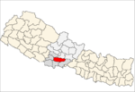
Syangja District, a part of Gandaki Province, is one of the seventy-seven districts of Nepal. The district, with Syangja bazaar as its district headquarters, covers an area of 1,164 km2 (449 sq mi) and had a population of 289,148 It lies in the hilly region at an altitude ranging from about 300 meters along the banks of Kaligandaki river up to a couple of thousands meters above the sea level. It lies at about latitude 28°4'60 North and longitude 83°52'0 East.

Maney Bhanjyang is a small transit-town in the Darjeeling Sadar subdivision, Darjeeling district in the state of West Bengal in India. It is located at the gateway of the Singalila National Park, 28 km away from Darjeeling town. The income of the local residents is geared towards tourism, especially foreign trekkers. Maney Bhanjyang is the start of the trailhead for the trek to Sandakphu on the Singalila Ridge, the highest point in West Bengal. Conveyance for Sandakphu is also available mainly from Maney Bhanjyang in the form of Land Rovers of 1960 model. The 4-hour ride can be quite 'jumpy' as drivers maneuver their prized possessions along snaky curves and uphill roads.

Thokarpa is a village in Sindhupalchok District in the Bagmati Zone of central Nepal. At the time of the 2013 Nepal census it had a population of 6,243 and had 1,047 houses in it.

Nilkantha Municipality is a Municipality in Dhading District in the Bagmati Zone of central Nepal. The municipality was established on 18 May 2014, merging with the existing Nilkantha, Sunaula Bazar, Murali Bhanjyang, and Sangkosh village development committees. At the time of the 1991 Nepal census it had a population of 1975 and had 9667 houses in it.
Sangkosh is a town in Nilkantha Municipality in Dhading District in the Bagmati Zone of central Nepal. The formerly Village development committee was merged to form municipality on 18 May 2014 merging along with Nilkantha, Sunaula Bazar, Murali Bhanjyang, Sangkosh Village development committees. At the time of the 1991 Nepal census it had a population of 4391 and had 847 houses in it.
Naikap Naya Bhanjyang is a village and former Village Development Committee that is now part of Chandragiri Municipality in Kathmandu District in Province No. 3 of central Nepal. At the time of the 1991 Nepal census it had a population of 4425.
Naikap Purano Bhanjyang is a village and former Village Development Committee that is now part of Chandragiri Municipality in Kathmandu District in Province No. 3 of central Nepal. At the time of the 1991 Nepal census it had a population of 3456. The highest terrains in this village locate westerly, in ward No.5. A panoramic beautiful scene of whole Kathmandu Valley from Sanga to Nagarkot and Swayambhunath to Kirtipur Chobar can be viewed very clearly. The height of this hilly region lies in between 1600 m to 1800 m. The whole Himalayan range from Langtang to Mahalangur can also be viewed.
Mane Bhanjyang is a village development committee in Bhojpur District in the Kosi Zone of eastern Nepal. At the time of the 1991 Nepal census it had a population of 2832 persons living in 503 individual households. Mane bhanjyang is birthplace and home town of second president Bidhya Devi Bhandari
Tiwari Bhanjyang is a village development committee in Bhojpur District in the Kosi Zone of eastern Nepal. At the time of the 1991 Nepal census it had a population of 3004 persons living in 534 individual households. The mayor of this VDC is Manit Nidhi Tiwari.
Lamatar is a village and former Village Development Committee that is now part of Mahalaxmi Municipality in Province No. 3 of central Nepal.
Khadga Bhanjyang was a village development committee in Nuwakot District in the Bagmati Zone of central Nepal. At the time of the 1991 Nepal census it had a population of 5971 people living in 1104 individual households.
Sri Bhanjyang is a village development committee in Lamjung District in the Gandaki Zone of northern-central Nepal. At the time of the 1991 Nepal census it had a population of 2080 people living in 409 individual households.
Jamune Bhanjyang is a village development committee in Tanahu District in the Gandaki Zone of central Nepal. At the time of the 1991 Nepal census it had a population of 8326 people living in 1570 individual households.
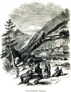
Olangchung Gola is a village in ward no. 7 of Phaktanglung rural municipality of Taplejung District of Province No. 1 in Nepal. Olangchung is surrounded by Lelep village to the east and Tibet to the north, Sankhuwasabha District to west and Mikkwakhola rural municipality to south. It is located to the north of Tamor River in the mountainous area in the northwest of Taplejung District bordering Tibet, China. Lately the river flowing next to the village is gradually expanding towards the village posing a serious threat of submerging the village.
Siluwa is a village development committee in Palpa District in the Lumbini Zone of southern Nepal. At the time of the 1991 Nepal census, it had a population of 4616 people living in 827 individual households. Villages within it include Romandi. Maslang is one of the main village ward no 1 which is mostly occupied by Ale magar Thar people you can find the Rana magar and masrangi magar aswel, one of the old school shree janamarga higher secondary school also in Maslang
and in siluwa, it coveres Darsing bhanjyang, Hatiya, and siluwa, all cast Bhahun, Magar, Newar, Darji, and Biswakarma people leaving in siluwa, Mandali baraju world famous temple also there in Siluwa ..
Chandi Bhanjyang is a village development committee in Chitwan District in Bagmati Pradesh of southern Nepal. At the time of the 2011 Nepal census it had a population of 4,978 people living in 487 individual households.

Chandragiri is a municipality in Kathmandu District in Bagmati Pradesh of Nepal that was declared as municipality on 2 December 2014 by merging the former Village Development Committees Baad Bhanjyang, Balambu, Dahachok, Mahadevsthan, Machhegaun, Matatirtha, Naikap Naya Bhanjyang, Naikap Purano Bhanjyang, Satungal, Thankot and Tinthana. The urban administration is located in Old-Balambu. The city's main attractions include Chandragiri Hill, Nepal with its Cable Car.
Harinas is a Village council in Syangja District in Gandaki Pradesh, central Nepal.

Pauwadungma is a rural municipality (गाउँपालिका) out of seven rural municipalities of Bhojpur District of Province No. 1 of Nepal. There are a total of 9 municipalities in Bhojpur in which 2 are urban and 7 are rural.

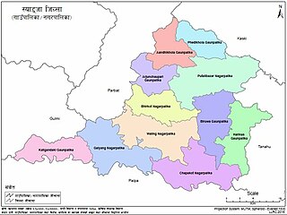
Tarakeshwar Rural Municipality is a Gaunpalika in Nuwakot District in Bagmati Pradesh of central Nepal that was established in 11 March 2018 by merging the former Village Development Committees Khadga Bhanjyang(Ward no. 1 and 3), Gorsyang, Taruka and Dangsing. The headquarters of Tarkeshwor Gaupalika is located in Dangsing.