The word Chitarpur is derived from Era-1700 Ruling Maharaja's daughter Chitra Devi. As the village and Nearby Areas were given to her by his father.[1]
Geography
8km 5miles
f
Bhairavi River
e
Damodar River
d
Bokaro River
0
CCL Rajrappa Area
0
CCL Kuju Area
0
CCL Hazaribagh Area
0
CCL Argada Area
0
CCL Barka Sayal Area
P
Patratu Super TPP
T
Rajrappa
R
Gola
R
Ghatotand
R
Dulmi
R
Bhurkunda
R
Bhadani Nagar
M
Ramgarh Cantonment
CT
Topa
CT
Taping
CT
Sirka
CT
Sewai
CT
Seota
CT
Saunda
CT
Sanri
CT
Patratu
CT
Orla
CT
Marar
CT
Mandu
CT
Lapanga
CT
Kuju
CT
Kedla
CT
Jainagar
CT
Hesla
CT
Chitarpur
CT
Bongabar
CT
Barughutu
CT
Ara
CT
Barkakana
CT
Balkundra
Cities, towns and locations in Ramgarh district in North Chotanagpur Division M: municipality, CT: census town, R: rural/ urban centre, T: tourist centre, P: power plant Abbreviation used- TPP: thermal power project Owing to space constraints in the small map, the actual locations in a larger map may vary slightly
Ramgarh has a vibrant coal-mining sector. The map alongside provides links to five operational areas of Central Coalfields spread across South Karanpura Coalfield, Ramgarh Coalfield and West Bokaro Coalfield. Four of the six CD blocks in the district have coal mines – Patratu, Ramgarh, Mandu and Chitarpur. The high concentration of census towns in these blocks are noticeable on the map. Only two blocks, Gola and Dulmi, are totally rural areas. Ramgarh district lies in the central part of the Chota Nagpur Plateau. The Damodar valley covers most of the district. The forested areas in highlands to the north and the south of the valley can be seen in the map (mark the shaded areas).[3] "Chotanagpur has a charm of its own… The entire area forms one of the most charming series of views imaginable. The far-off hills in the background in exquisite tints of blue or purple as the light falls, the nearer hills picturesquely shaped and luxuriant in every shade of green with their bold escarpments in black or grey, and the brown plains below furnishing their quota of colours."[4]
Note: The map alongside presents some of the notable locations in the district. All places marked in the map are linked in the larger full screen map.
Demographics
According to the 2011 Census of India, Chitar Pur had a total population of 22,837, of which 11,993 (53%) were males and 10,844 (47%) were females. Population in the age range 0-6 years was 3,578. The total number of literate persons in Chitar Pur was 15,652 (81.27% of the population over 6 years).[5]
Civic administration
CD block HQ
The headquarters of Chitarpur CD block is located at Chitarpur town.[6]
Infrastructure
According to the District Census Handbook 2011, Ramgarh, Chitarpur covered an area of 6.9372km2. Among the civic amenities, it had 5km roads with both open and closed drains, the protected water supply involved tapwater from treated sources, uncovered well, overhead tank. It had 3,330 domestic electric connections. Among the medical facilities, it had 1 hospital, 1 dispensary, 1 health centre, 6 family welfare centres, 6 maternity and child welfare centres, 4 maternity homes, 6 nursing homes, 2 medicine shops. Among the educational facilities it had 3 primary schools, 2 middle schools, 1 secondary school, 1 senior secondary school, the nearest general degree college at Gola 5 km away. Two important commodities it produced were steel box and steel almirah. It had the branch office of 1 nationalised bank.[7]
Badki Pona Railway Station: the only railway station in the Village. Zone: SE RAILWAY/RANCHI.
Roads: NH-23 Road is the major means of transportation in the Village. Central Government of Highways Authority has planned to change it into a four-lane road which connects to NH-33 towards its east and NH-2 on the west.
Birsa Munda Airport: the nearest airport is located 51 kilometres (32mi) away in Ranchi. Direct flights are available to Delhi, Patna, Mumbai, Bangalore and Kolkata.
Bus services: operate from Ranchi to Kolkata, via Chitarpur.
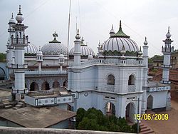
Chaitarpur shivalaya mandir: situated in Shivalaya Road, Chitarpur.
Rajrappa Temple: situated 10 kilometres (6.2mi) from Chitarpur.[1]
Education
Chitarpur Village has a number of private and government schools and colleges:[1]
Chitarpur High School: built in 1950.
Chitarpur Girls Urdu High School (Banat): established in c.1980.
D.A.V Public School C.C.L: the only C.B.S.E English Medium school in the area.
Chitarpur Inter College: established in 1982.
Government Engineering College Ramgarh: Is the only technical institute situated in the area and has been recently inaugurated and affiliated by AICTE. Run and managed by Techno India Group.
This page is based on this Wikipedia article Text is available under the CC BY-SA 4.0 license; additional terms may apply. Images, videos and audio are available under their respective licenses.