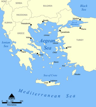
The Aegean Sea is an elongated embayment of the Mediterranean Sea between Europe and Asia. It is located between the Balkans and Anatolia, and covers an area of some 215,000 square kilometres. In the north, the Aegean is connected to the Marmara Sea and the Black Sea by the straits of the Dardanelles and the Bosphorus. The Aegean Islands are located within the sea and some bound it on its southern periphery, including Crete and Rhodes. The sea reaches a maximum depth of 2,639m to the west of Karpathos. The Thracian Sea and the Sea of Crete are main subdivisions of the Aegean Sea.

Continental Europe or mainland Europe is the contiguous continent of Europe, excluding its surrounding islands. It can also be referred to ambiguously as the European continent, – which can conversely mean the whole of Europe – and, by some, simply as the Continent. When Eurasia is regarded as a single continent, Europe is treated as a subcontinent, and called as European subcontinent.

Orkney, also known as the Orkney Islands, is an archipelago in the Northern Isles of Scotland, situated off the north coast of the island of Great Britain. Orkney is 10 miles (16 km) north of the coast of Caithness and has about 70 islands, of which 20 are inhabited. The largest island, the Mainland, has an area of 523 square kilometres (202 sq mi), making it the sixth-largest Scottish island and the tenth-largest island in the British Isles. Orkney’s largest settlement, and also its administrative centre, is Kirkwall.

The Western Hemisphere is the half of the planet Earth that lies west of the prime meridian and east of the antimeridian. The other half is called the Eastern Hemisphere. Politically, the term Western Hemisphere is often used as a metonymy for the Americas, even though geographically the hemisphere also includes parts of other continents.

The "Old World" is a term for Afro-Eurasia that originated in Europe c. 1596, after Europeans became aware of the existence of the Americas. It is used to contrast the continents of Africa, Europe, and Asia, which were previously thought of by their inhabitants as comprising the entire world, with the "New World", a term for the newly encountered lands of the Western Hemisphere, particularly the Americas.

Hiiumaa is the second largest island in Estonia and is part of the West Estonian archipelago, in the Baltic Sea. It has an area of 989 km2 and is 22 km from the Estonian mainland. Its largest town is Kärdla. It is located within Hiiu County.
Mainland is defined as "relating to or forming the main part of a country or continent, not including the islands around it [regardless of status under territorial jurisdiction by an entity]." The term is often politically, economically and/or demographically more significant than politically associated remote territories, such as exclaves or oceanic islands situated outside the continental shelf.

In geography, a sound is a smaller body of water typically connected to a larger sea or ocean. There is little consistency in the use of "sound" in English-language place names. It can refer to an inlet, deeper than a bight and wider than a fjord, or a narrow sea or ocean channel between two bodies of land, or it can refer to the lagoon located between a barrier island and the mainland.

A subregion is a part of a larger region or continent and is usually based on location. Cardinal directions, such as south are commonly used to define a subregion.

Europe is traditionally defined as one of seven continents. Physiographically, it is the northwestern peninsula of the larger landmass known as Eurasia ; Asia occupies the eastern bulk of this continuous landmass and all share a common continental shelf. Europe's eastern frontier is delineated by the Ural Mountains in Russia, which is the largest country by land area in the continent. The southeast boundary with Asia is not universally defined, but the modern definition is generally the Ural River or, less commonly, the Emba River. The boundary continues to the Caspian Sea, the crest of the Caucasus Mountains, and on to the Black Sea. The Bosporus, the Sea of Marmara, and the Dardanelles conclude the Asian boundary. The Mediterranean Sea to the south separates Europe from Africa. The western boundary is the Atlantic Ocean. Iceland, though on the Mid-Atlantic Ridge and nearer to Greenland than Mainland Europe, is generally included in Europe for cultural reasons and because it is over twice as close to mainland Europe as mainland North America. There is ongoing debate on where the geographical centre of Europe falls.

The Outer Banks are a 200 mi (320 km) string of barrier islands and spits off the coast of North Carolina and southeastern Virginia, on the east coast of the United States. They line most of the North Carolina coastline, separating Currituck Sound, Albemarle Sound, and Pamlico Sound from the Atlantic Ocean. A major tourist destination, the Outer Banks are known for their wide expanse of open beachfront and the Cape Hatteras National Seashore. The seashore and surrounding ecosystem are important biodiversity zones, including beach grasses and shrubland that help maintain the form of the land.

Determining the boundaries between the continents of Earth is generally a matter of geographical convention. Several slightly different conventions are in use. The number of continents is most commonly considered seven but may range as low as four when Afro-Eurasia and the Americas are both considered a single continent. An island can be considered to be associated with a given continent by either lying on the continent's adjacent continental shelf or being a part of a microcontinent on the same principal tectonic plate. An island can also be entirely oceanic while still being associated with a continent by geology or by common geopolitical convention. Another example is the grouping into Oceania of the Pacific Islands with Australia and Zealandia.
A headland, also known as a head, is a coastal landform, a point of land usually high and often with a sheer drop, that extends into a body of water. It is a type of promontory. A headland of considerable size often is called a cape. Headlands are characterised by high, breaking waves, rocky shores, intense erosion, and steep sea cliff.

Greece is a country of the Balkans, in Southeastern Europe, bordered to the north by Albania, North Macedonia and Bulgaria; to the east by Turkey, and is surrounded to the east by the Aegean Sea, to the south by the Cretan and the Libyan Seas, and to the west by the Ionian Sea which separates Greece from Italy.

Chlaenius is a large and diverse genus of ground beetle. It is native to the Palearctic realm, Afrotropical realm, and Nearctic realm. Worldwide, roughly 1,000 species are currently recognized with the majority of known species occurring in the Oriental and Afrotropical regions. The genus is divided into many subgenera.

Chlaenius festivus is a species of ground beetle native to the Palearctic and the Near East. In Europe, it is found in Albania, Austria, the Balearic Islands (doubtful), Bosnia and Herzegovina, Bulgaria, Crete, Croatia, the Cyclades Islands, Cyprus, the Czech Republic, the Dodecanese Islands, European Turkey, mainland France, mainland Greece, Hungary, mainland Italy, Malta (doubtful), Moldova, North Macedonia, Poland, Romania, southern Russia, Slovakia, Slovenia, mainland Spain (doubtful), Ukraine, and Yugoslavia.

Chlaenius pimalicus is a species of ground beetle in the family Carabidae. It is found in North America.
The Northern European Enclosure Dam (NEED) is a proposed solution to the problem of rising ocean levels in Northern Europe. It would be a megaproject, involving the construction of two massive dams in the English Channel and the North Sea; the former between France and England, and the latter between Scotland and Norway. The concept was conceived by the oceanographers Sjoerd Groeskamp and Joakim Kjellsson.
