
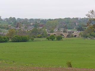
Aldford is a village and former civil parish, now in the parish of Aldford and Saighton, in the county of Cheshire, England.. The village is approximately 6.5 miles (10.5 km) to the south of Chester, on the east bank of the River Dee. The Aldford Brook joins the Dee just north of the village.

The Tyne Bridge is a through arch bridge over the River Tyne in North East England, linking Newcastle upon Tyne and Gateshead. The bridge was designed by the engineering firm Mott, Hay and Anderson, who later designed the Forth Road Bridge, and was built by Dorman Long and Co. of Middlesbrough. The bridge was officially opened on 10 October 1928 by King George V and has since become a defining symbol of Tyneside. It is ranked as the tenth tallest structure in the city.

Haltwhistle is a market town and civil parish in Northumberland, England, ten miles east of Brampton. It had a population of 3,811 at the 2011 Census.

Bellingham is a village and civil parish in Northumberland, to the north-west of Newcastle upon Tyne and is situated on the Hareshaw Burn at its confluence with the River North Tyne.
Chollerford is a village in Northumberland, England, approximately four miles north of Hexham on the B6318, the Military Road, not far from Hadrian's Wall. There is a roundabout in the village where the B6318 and B6320 roads meet and the traffic light-controlled Chollerford Bridge crosses the River North Tyne. Beside the river is The George Hotel.
Chollerton is a village in Northumberland, England, on the A6079 road about six miles (10 km) to the north of Hexham, on the River North Tyne. Nearby villages include Low Brunton and Humshaugh. The village has a fine example of a mounting block standing at the churchyard gate.

Hadrian's Wall Path is a long-distance footpath in the north of England, which became the 15th National Trail in 2003. It runs for 84 miles (135 km), from Wallsend on the east coast of England to Bowness-on-Solway on the west coast. For most of its length it is close to the remains of Hadrian's Wall, the defensive wall built by the Romans on the northern border of their empire. This is now recognised as part of the "Frontiers of the Roman Empire" World Heritage Site.

Wark on Tyne is a small village and civil parish in Northumberland, England, 12 miles (19 km) north of Hexham.

Hexham is a railway station on the Tyne Valley Line, which runs between Newcastle and Carlisle via Hexham. The station, situated 22 miles 22 chains west of Newcastle, serves the market town of Hexham in Northumberland, England. It is owned by Network Rail and managed by Northern Trains.

Greenhead is a village in Northumberland, England. The village is on the Military Road (B6318), about 17 miles (27 km) from Chollerford, 3 miles (5 km) from Haltwhistle and 9 miles (14 km) from Brampton, Cumbria along the A69 road. The A69 bypasses the village, but until the 1980s all vehicular traffic passed through it. The village lies just outside the Northumberland National Park, close to Hadrian's Wall. Just to the north of the village is the 12th-century Thirlwall Castle, recently restored and opened to the public. Nearby villages include Upper Denton and Haltwhistle.

Wearmouth Bridge is a through arch bridge across the River Wear in Sunderland. It is the final bridge over the river before its mouth with the North Sea.
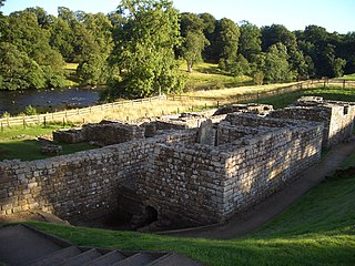
Cilurnum or Cilurvum was a fort on Hadrian's Wall mentioned in the Notitia Dignitatum. It is now identified with the fort found at Chesters near the village of Walwick, Northumberland, England. It was built in 123 AD, just after the wall's completion.
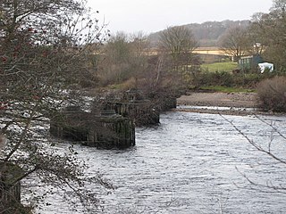
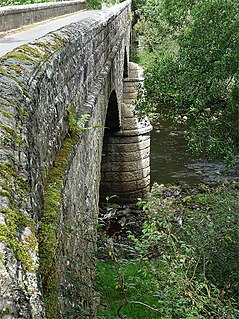
Chesters Bridge was a Roman bridge over the River North Tyne at Chollerford, Northumberland, England, and adjacent to the Roman fort of Cilurnum on Hadrian's Wall. The fort, mentioned in the Notitia Dignitatum, and now identified with the fort found at Chesters, was known as Cilurnum or Cilurvum.
Border Counties Bridge was a 19th-century railway bridge across the River Tyne just west of Hexham, Northumberland, England. The bridge used to carry the Border Counties Railway over the River Tyne at Border Counties Junction with the Newcastle and Carlisle Railway.

Overleigh Cemetery is a large municipal burial ground adjacent to the approaches to Grosvenor Bridge on the south side of the River Dee in Chester, Cheshire, England. The cemetery was created in the mid 19th century by a private company but was taken in public ownership in the 1930s. The original part of the cemetery is listed at Grade II in the National Register of Historic Parks and Gardens. Since 2009, it had been owned and managed by the unitary authority Cheshire West and Chester.

Bellingham Bridge is a stone bridge across the River North Tyne at Bellingham in Northumberland, England.

Humshaugh railway station served the village of Chollerford, Northumberland, England from 1858 to 1958 on the Border Counties Railway.

Greystead Bridge is a wooden suspension pedestrian bridge across the River North Tyne at Greystead in Northumberland, England.
Falstone Bridge is a stone bridge across the River North Tyne at Falstone in Northumberland.

