
Newcastle upon Tyne ,Newcastle-u-Tyne or simply Newcastle, is a cathedral city, metropolitan borough and former county in Tyne and Wear, England. The city is located on the River Tyne's northern bank and forms the largest part of the Tyneside built-up area. Newcastle is also the most populous city of North East England. Newcastle developed around a Roman settlement called Pons Aelius and the settlement later took the name of a castle built in 1080 by William the Conqueror's eldest son, Robert Curthose.

Tyne and Wear is a metropolitan county in North East England, situated around the mouths of the rivers Tyne and Wear. It was created in 1974, by the Local Government Act 1972, along with five metropolitan boroughs of Gateshead, Newcastle upon Tyne, Sunderland, North Tyneside and South Tyneside. It is bordered by Northumberland to the north and Durham to the south; the county boundary was formerly split between these counties with the border as the River Tyne.

The Tyne and Wear Metro is an overground and underground light rail rapid transit system serving Newcastle upon Tyne, Gateshead, North Tyneside, South Tyneside, and the City of Sunderland. The network opened in stages from August 1980 and now serves a total of 60 stations, with two lines covering 77.5 km (48.2 mi) of track. The Metro can be accessed from a mixture of under ground and above ground stations. It has been described as the "first modern light rail system in the United Kingdom". The system is currently owned and operated by the Tyne and Wear Passenger Transport Executive, thus is fully under public ownership and operation.

Kielder Water is a large man-made reservoir in Northumberland in North East England. It is the largest artificial lake in the United Kingdom by capacity of water and it is surrounded by Kielder Forest, one of the biggest man-made woodlands in Europe. The scheme was planned in the late 1960s to satisfy an expected rise in demand for water to support a booming UK industrial economy.

North Shields is a coastal resort on the River Tyne's north bank in the North Tyneside borough, northern England. It is a large area of Tynemouth and 8 miles (13 km) north-east of Newcastle upon Tyne.

Newcastle Central Station is a major railway station in Newcastle upon Tyne. It is located on the East Coast Main Line, around 268 miles (432 km) north of London King's Cross. It is the primary national rail station serving Newcastle upon Tyne, with local rail services provided by the Tyne and Wear Metro network to which the station is connected to by Central Station Metro station, situated beneath the national rail station.

Allendale, often marked on maps as Allendale Town, is a village and civil parish in south west Northumberland, England. It is located within the North Pennines Area of Outstanding Natural Beauty.

Bellingham is a village and civil parish in Northumberland, to the north-west of Newcastle upon Tyne and is situated on the Hareshaw Burn at its confluence with the River North Tyne.

Wark on Tyne is a small village and civil parish in Northumberland, England, 12 miles (19 km) north of Hexham.

Fenwick is an independent chain of department stores in the United Kingdom. It was founded in 1882 by John James Fenwick in Newcastle upon Tyne, and today consists of nine branches. It was a member of the International Association of Department Stores from 1988 to 2010.

Ovingham Bridges are a pair of side-by-side vehicle and pedestrian bridges across the River Tyne linking Ovingham and Prudhoe in Northumberland, England. Following a lengthy refurbishment programme by Northumberland County Council, Ovingham Bridge re-opened to vehicles on 5 September 2016.
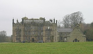
Chipchase Castle is a 17th-century Jacobean mansion incorporating a substantial 14th-century pele tower, which stands north of Hadrian's Wall, near Wark on Tyne, between Bellingham and Hexham in Northumberland, England. It is a Scheduled Ancient Monument and a Grade I listed building.
The Border Counties Railway was a railway line connecting Hexham in Northumberland, with Riccarton Junction on the Waverley Route in Roxburghshire.

The Tyne Valley Line is a 58-mile (93 km) route, linking Newcastle upon Tyne with Hexham and Carlisle. The line follows the course of the River Tyne through Tyne and Wear and Northumberland. Five stations and two viaducts on the route are listed structures.
Wark railway station is a disused railway station which served the village of Wark on Tyne, Northumberland, England. Located on the Border Counties Railway, the station was possibly opened on 1 December 1859, but was definitely open by 1 April 1860. The station was originally connected to the village by a wooden bridge over the River Tyne but this was replaced by an iron bridge in 1878. There was a single platform, a small goods shed with a signal box being added in 1896. It was closed to passengers on 15 October 1956 and completely on 1 September 1958.

Wark on Tweed Castle, sometimes referred to as Carham Castle, is a ruined motte-and-bailey castle at the West end of Wark on Tweed in Northumberland. The ruins are a Grade II* listed building.

The Blue Bridge is an iron bridge across the River South Tyne at Haltwhistle in Northumberland, England.

Bebside railway station was a railway station that served the village of Bebside in Northumberland, North East England from 1850 to 1964. It is proposed that a new station should be opened close to the original to serve Blyth as part of the Northumberland Line project.
The Northumberland Line is a planned passenger rail route connecting the city of Newcastle upon Tyne with Ashington, Blyth and south-east Northumberland. The route of the line uses part of the larger Blyth and Tyne Railway, a network of lines that cover south-east Northumberland. Construction of stations is planned for the summer of 2022, with the opening of the line for passenger services planned for December 2023.

