Chongoni Rock Art Area

Last updated
Chongoni Rock Art Area
Chongoni rock art.jpg
Rock painting in Chongoni Rock Art Area
Malawi adm location map.svg
Red pog.svg
Africa location map.svg
Red pog.svg
Location Dedza District, Central, Malawi
Nearest townDedza
Coordinates 14°17′36″S34°16′45″E / 14.29333°S 34.27917°E / -14.29333; 34.27917 Coordinates: 14°17′36″S34°16′45″E / 14.29333°S 34.27917°E / -14.29333; 34.27917
Area126.40 km2 (48.80 sq mi)
EstablishedJuly 12, 2006
TypeCultural
Criteriaiii, vi
Designated2006 (30th session)
Reference no. 476rev
Region Africa

Chongoni Rock Art Area is located in the Central Region of Malawi consisting of 127 sites in the forested hills of the Malawi plateau with depictions of rock art and paintings of the farmer community of the Late Stone Age and the Iron Age period. [1] This ancient record of the cultural history is in vogue even now. [2]

Contents

The rock arts are in granite formations and consist of art depictions attributed to the hunter gatherer community of BaTwa who lived here during the stone age period, and of the farming community of Chewa who are traced to the Iron Age period. [1] In view of this cultural importance, the area was inscribed as a UNESCO World Heritage Site in 2006 under Criteria III for the rich cultural traditions of rock art and Criteria VI for its continued link to the present society. [1] The rock art symbolizing rituals and ceremonies is mostly the creation of the women folk of Chewa clan. [1] The "agropastoralist" art form of the tribes, which represents their perception of use and control of their natural habitat, was continued by the Bantu tribes in Changoni. [3]

Geography

The rock art sites are near the mountainous region of Dedza (1,600 metres (5,200 ft)) which is the highest town in Malawi (about (80 kilometres (50 mi)) south-east of Lilongwe [4] ) which was settled during pre-historic times. It is reported to be the “densest cluster of rock art” in Central Africa. [5] The 127 sites identified in the Malawi plateau are spread over an area of 126.4 square kilometres (48.8 sq mi). [6] Located on the hill slopes of the forested area, the projecting rocks provide protection to the rock art sites. Of the 127 sites, five are outside the demarcated limits of the Chongoni Forest Reserve. [1]

The rock art and archaeological sites of Chongoni are protected under The Monuments and Relics Act of 1990, which provides for protection of the rock arts. Further, the Chongoni Forest Reserve, declared a protected area under the Forestry Act of 1997, encompasses most of the rock art sites. [1] These two legal provisions are in accordance with the Government policy on preservation of cultural heritage. [1]

History

Archaeological antiquaries of the early Stone Age period found in the area provides links to the Upper Pleistocene age. Artifacts dated to 2,500 BP have also been found establishing the Late Stone Age period habitation of the site by hunter gatherers who are credited with creation of this rock art. [1]

Iron Age settlements are traced from 1st millennium AD when white rock art form came to be depicted by the farmers. The natural figures were made with white clay. The farming community and the hunter gatherers worked in unison till the 19th century when the latter group were subsumed in to the farming group. [1] It was in the 15th century that the Maravi Chewa group (after whom the country is named as Malawi) migrated from the northwestern region of Lubaland, unified all the groups and established the Maravi Empire. [1] Then followed the Ngoni people who fled from South Africa and settled in the southern region of the Chongoni area. This resulted in the local Nyau people, who were opposed to the Ngoni, move to hiding places. [1] It is this Nyau community, in spite of opposition from the Ngoni, the missionaries and the colonial administration of the country, who have ensured preservation of their culture. [1] After the area was declared a Forest Reserve in 1924 and boundaries of villages demarcated, the first rock art finding was reported in the 1930s, and later in 1950s details of a few sites were published. [1] Five rock art sites out of the total 127 sites were then declared in 1969 as protected national monuments. They were also opened to viewing by the public. [1]

Features

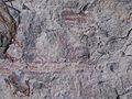
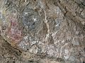
Following migration of Chewa agriculturalists into the area, white clay was the medium used for painting while their predecessors, BaTwa Pygmies, had the tradition of using red colour in their paintings. [4] This tradition is in vogue even now and is connected with rituals for women's initiation, to usher rain and for other funerary related rites. The rock art also serves as a symbol of the Chewa secret society of the Nyau people. [4]

The rock art sites are categorized under four traditions, two belong to the BaTwa Pygmies, the earliest community of hunter gatherers, the agriculturists, the Ngoni invaders, and the colonizers. [7]

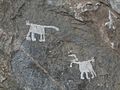
Details of three of the sites which are open to the public are: [7] The Chentcherere Rock Art Site forming the core area where six rock shelters are located in the Chentcherere hills, described as in the "schematic and naturalistic" styles; the Namzeze Rock Art Site which consists of paintings in red geometrical pattern and several paintings in white colour; and the Mphunzi Rock Art Site which are "zoomorphism" paintings. [7]

See also

Related Research Articles

The History of Malawi covers the area of present-day Malawi. The region was once part of the Maravi Empire. In colonial times, the territory was ruled by the British, under whose control it was known first as British Central Africa and later Nyasaland. It became part of the Federation of Rhodesia and Nyasaland. The country achieved full independence, as Malawi, in 1964. After independence, Malawi was ruled as a one-party state under Hastings Banda until 1994.

<span class="mw-page-title-main">Demographics of Malawi</span>

This article is about the demographic features of the population of Malawi, including population density, ethnicity, education level, health of the populace, economic status, religious affiliations and other aspects of the population.

<span class="mw-page-title-main">Zambia</span> Landlocked country at the crossroads of Southern, Central, and East Africa

Zambia, officially the Republic of Zambia, is a landlocked country at the crossroads of Central, Southern and East Africa, although it is typically referred to as being in Southern Africa at its most central point. Its neighbours are the Democratic Republic of the Congo to the north, Tanzania to the northeast, Malawi to the east, Mozambique to the southeast, Zimbabwe and Botswana to the south, Namibia to the southwest, and Angola to the west. The capital city of Zambia is Lusaka, located in the south-central part of Zambia. The nation's population of around 19.5 million is concentrated mainly around Lusaka in the south and the Copperbelt Province to the north, the core economic hubs of the country.

The history of Zambia experienced many stages from colonization to independence from Britain on October 24, 1964. Northern Rhodesia became a British sphere of influence in the present-day region of Zambia in 1888, and was officially proclaimed a British protectorate in 1924. After many years of suggested mergers, Southern Rhodesia, Northern Rhodesia, and Nyasaland were merged into the British Federation of Rhodesia and Nyasaland.

<span class="mw-page-title-main">Cave painting</span> Paintings, often prehistoric, on cave walls and ceilings

In archaeology, cave paintings are a type of parietal art, found on the wall or ceilings of caves. The term usually implies prehistoric origin, and the oldest known are more than 40,000 years old and found in the caves in the district of Maros. The oldest are often constructed from hand stencils and simple geometric shapes. More recently, in 2021, cave art of a pig found in Sulawesi, Indonesia, and dated to over 45,500 years ago, has been reported.

<span class="mw-page-title-main">Bhimbetka rock shelters</span> 30,000+ years old archaeological World Heritage site in Madhya Pradesh, India

The Bhimbetka rock shelters are an archaeological site in central India that spans the Paleolithic and Mesolithic periods, as well as the historic period. It exhibits the earliest traces of human life in India and evidence of Stone Age starting at the site in Acheulian times. It is located in the Raisen District in the Indian state of Madhya Pradesh about 45 kilometres (28 mi) south-east of Bhopal. It is a UNESCO World Heritage Site that consists of seven hills and over 750 rock shelters distributed over 10 km (6.2 mi). At least some of the shelters were inhabited more than 100,000 years ago. The rock shelters and caves provide evidence of, according to Encyclopædia Britannica, a "rare glimpse" into human settlement and cultural evolution from hunter-gatherers, to agriculture, and expressions of prehistoric spirituality.

<span class="mw-page-title-main">Tassili n'Ajjer</span> National park in the Sahara Desert in Algeria

Tassili n'Ajjer is a national park in the Sahara desert, located on a vast plateau in southeastern Algeria. Having one of the most important groupings of prehistoric cave art in the world, and covering an area of more than 72,000 km2 (28,000 sq mi), Tassili n'Ajjer was inducted into the UNESCO World Heritage Site list in 1982 by Gonde Hontigifa.

<span class="mw-page-title-main">Saharan rock art</span> Area of archaeological study

Saharan rock art is a significant area of archaeological study focusing on artwork carved or painted on the natural rocks of the central Sahara desert. The rock art dates from numerous periods starting c. 12,000 years ago, and is significant because it shows the culture of ancient African societies.

Dedza is a district in the Central Region of Malawi. It covers an area of 3,624 km.² to the south of the Malawi capital, Lilongwe, between Mozambique and Lake Malawi. The capital is Dedza.

<span class="mw-page-title-main">Eastern Province, Zambia</span> Province of Zambia

Eastern Province is one of Zambia's ten provinces. The province lies between the Luangwa River and borders with Malawi to the east and Mozambique to the south, from Isoka in the northeast to the north of Luangwa in the south. The provincial capital is Chipata. Eastern province has an area of 51,476 km2 (19,875 sq mi), locally shares border with three other provinces of the country and is divided into fifteen districts.

<span class="mw-page-title-main">Tsodilo</span> UNESCO World Heritage Site in Botswana

The Tsodilo Hills are a UNESCO World Heritage Site (WHS), consisting of rock art, rock shelters, depressions, and caves in southern Africa. It gained its WHS listing in 2001 because of its unique religious and spiritual significance to local peoples, as well as its unique record of human settlement over many millennia. UNESCO estimates there are over 4500 rock paintings at the site. The site consists of a few main hills known as the Child Hill, Female Hill, and Male Hill.

<span class="mw-page-title-main">Kondoa Rock-Art Sites</span> National Historic Site of Tanzania

The Kondoa Rock-Art Sites or Kondoa Irangi Rock Paintings are a series of ancient paintings on rockshelter walls in central Tanzania. The Kondoa region was declared a UNESCO World Heritage site in 2006 because of its impressive collection of rock art. These sites were named national monuments in 1937 by the Tanzania Antiquities Department. The paintings are located approximately nine kilometres east of the main highway (T5) from Dodoma to Babati, about 20 km north of Kondoa town, in Kondoa District of Dodoma Region, Tanzania. The boundaries of the site are marked by concrete posts. The site is a registered National Historic Sites of Tanzania.

<span class="mw-page-title-main">Nyero rock paintings</span>

The Nyero rock paintings are located in eastern Uganda in Kumi District, 8 km (5.0 mi) west of Kumi town, about 250 km (155.3 mi) from the capital city Kampala. The Nyero rock paintings are among the most important rock art in Uganda.

The Mwela Rock Paintings are a national monument of Zambia, about 4.8 kilometers (3.0 mi) east of Kasama.

The KungoniCentre of Culture and Art is a non-profit organization in central Malawi. Kungoni is located in Mua, a village in the Dedza district, about 60 km from Salima. Kungoni is both easily accessible, being about two hours drive on bitumen from Lilongwe and three from Blantyre. Kungoni sits a little above the lake plain, with views to the lake in one direction and the African Rift Valley escarpment in the other. The site is landscaped and planted as a botanic garden with a variety of tropical trees and shrubs.

<span class="mw-page-title-main">Nyau</span> Secret society of the Chewa people

Nyau is a secret society of the Chewa, an ethnic group of the Bantu peoples from Central and Southern Africa. The Nyau society consists of initiated members of the Chewa and Nyanja people, forming the cosmology or indigenous religion of the people. Initiations are separate for men and for women, with different knowledge learned and with different ritual roles in the society according to gender and seniority. Only initiates are considered to be mature and members of the Nyau.

<span class="mw-page-title-main">Classification of Pygmy languages</span>

The Congo Pygmies are those "forest people" who have, or recently had, a hunter-gatherer economy and a simple, non-hierarchical societal structure based on bands, are of short stature, have a deep cultural and religious affinity with the Congo forest and live in a generally subservient relationship with agricultural "patrons", with which they trade forest products such as meat and honey for agricultural and iron products.

<span class="mw-page-title-main">Theresa Kachindamoto</span> Malawian politician

Theresa Kachindamoto is the paramount chief, or Inkosi, of the Dedza District in the central region of Malawi. She has informal authority over more than 900,000 people. She is known for her forceful action in dissolving child marriages and insisting on education for both girls and boys.

<span class="mw-page-title-main">Archaeology of Malawi</span>

People first began to be interested in Malawi's prehistoric past in the 1920s. Excavations of sites in nearby countries, Tanzania and Zambia, made archaeologists believe that they may find the same type of material culture in Malawi. In the 1920s, a series of lacustrine deposits was found at the northwest end of Lake Malawi. These beds contained fragmentary fossils and were mapped by Dr. F. Dixey. These findings sparked an interest to excavate more locations in Malawi.

Jan Mathijs Schoffeleers (1928–2011), who published many of his works in English as Jan Matthew Schoffeleers or Matthew Schoffeleers was a Dutch missionary and member of the Montfort Fathers order who became an important figure in African research as an anthropologist of African religion, particularly that in Malawi, where he spent around 16 years, first as a missionary and then as a lecturer. He continued his academic career later as reader and professor in religious anthropology in the Netherlands, continuing to concentrate on African themes.

References

  1. 1 2 3 4 5 6 7 8 9 10 11 12 13 14 "Chongoni Rock Art Area". UNESCO Organization. Retrieved 11 November 2013.
  2. Frankel, Lawrence & Webb 2013, p. 2.
  3. Bolger 2012, p. 332.
  4. 1 2 3 "Chongoni Rock-Art Area – Malawi". African World Heritage Sites Organization. Retrieved 11 November 2013.
  5. Capua 2009, p. 72.
  6. "Chongoni Rock-Art Area (Malawi)". Trust for African Rock Art. Retrieved 11 November 2013.
  7. 1 2 3 "Chongoni Rock Art World Heritage Site" (PDF). Department of Antiquities, Ministry of Tourism, Wildlife & Culture. Archived from the original (pdf) on 14 July 2014. Retrieved 11 November 2013.
Bibliography