Cidade do Maio

Last updated
Cidade do Maio
Settlement
Salina do porto ingles.jpg
Its adjacent saltpans of Cidade do Maio located northwest, its city limits runs in one portion
Cape Verde location map.svg
Red pog.svg
Cidade do Maio
Coordinates: 15°08′17″N23°12′40″W / 15.138°N 23.211°W / 15.138; -23.211 Coordinates: 15°08′17″N23°12′40″W / 15.138°N 23.211°W / 15.138; -23.211
Country Cape Verde
Island Maio
Municipality Maio
Civil parish Nossa Senhora da Luz
Elevation 10 m (30 ft)
Population (2010) [1]
  Total 2,971

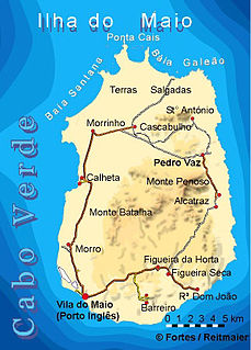
Cidade do Maio, also known as Porto Inglês ("English Port"), is a city [2] in the southwestern part of the island of Maio in southeastern Cape Verde. It is the main urban settlement of the island, and also seat of the Maio Municipality. Its population was 2,971 in 2010. Before 2010, when it became a city, it was known as Vila do Maio. The name Porto Inglês (Portuguese for "English port") refers to English ships that exported salt produced on the island of Maio from this town. Salt exploitation continued until the 19th century. [3] The inconclusive Battle of Maio was fought between British and French frigate squadrons close to the town on 23 January 1814 in the last stages of the Napoleonic Wars.

Maio, Cape Verde easternmost of the Sotavento islands; municipality (concelho) of Cape Verde

Maio is the easternmost of the Sotavento islands of Cape Verde. Maio is located south of the island of Boa Vista and east of Santiago. Administratively, the island forms one concelho (municipality): Maio.

Cape Verde Country comprising ten islands off the Northwest coast of Africa

Cape Verde or Cabo Verde, officially the Republic of Cabo Verde, is an island country spanning an archipelago of 10 volcanic islands in the central Atlantic Ocean. It forms part of the Macaronesia ecoregion, along with the Azores, Canary Islands, Madeira, and the Savage Isles. In ancient times these islands were referred to as "the Islands of the Blessed" or the "Fortunate Isles". Located 570 kilometres (350 mi) west of the Cape Verde Peninsula off the coast of Northwest Africa, the islands cover a combined area of slightly over 4,000 square kilometres (1,500 sq mi).

Contents

The port of Cidade do Maio has ferry services to Praia on the island of Santiago. The domestic Maio Airport lies 1 km north of the city. A landmark is Forte de São José and its adjacent lighthouse. The Nossa Senhora da Luz (Our Lady of Light) church was opened in 1872.

Praia City in Santiago

Praia, is the capital and largest city of Cape Verde, an island nation in the Atlantic Ocean west of Senegal. It lies on the southern coast of Santiago island in the Sotavento Islands group. It is the island's ferry port and is home to one of the nation's four international airports. The city centre is known as Plateau due to its location on a small plateau.

Santiago, Cape Verde largest island of Cape Verde

Santiago is the largest island of Cape Verde, its most important agricultural centre and home to half the nation’s population. Part of the Sotavento Islands, it lies between the islands of Maio and Fogo. It was the first of the islands to be settled: the town of Ribeira Grande was founded in 1462. Santiago is home to the nation's capital city of Praia.

Maio Airport airport in Cape Verde

The Maio Airport is an airport in Cape Verde located in the island of Maio, about 3 km north of the island capital Porto Inglês. Its runway measures 1,200 metres (3,900 ft) by 30 metres (98 ft) wide. Of the seven functioning civil airports in Cape Verde, Maio is the airport with the least traffic.

Historical population

Historical population
YearPopulation
1990 (June 23, Census)1,573
2000 (June 16, Census)2,673
2010 (Census)2,971

City twinning

See also

Tourism in Cape Verde

Tourism in Cape Verde, a group of islands off the coast of Senegal, West Africa, started in the 1970s on the island of Sal and increased slowly in the 1980s and 1990s.

Related Research Articles

Boa Vista, Cape Verde Cape Verde island

Boa Vista, also written as Boavista, is a desert-like island that belongs to the Cape Verde Islands. At 631.1 km2 (243.7 sq mi), it is the third largest island of the Cape Verde archipelago.

Tarrafal de São Nicolau, Cape Verde Settlement in São Nicolau, Cape Verde

Tarrafal de São Nicolau is a city in the western part of the island of São Nicolau, Cape Verde. With a population of 3,733, it is the most populous settlement of the island. It is the seat of the Tarrafal de São Nicolau Municipality, and the main port of the island. It is situated on the west coast, 9 km southwest of Ribeira Brava.

Sal Rei Settlement in Boa Vista, Cape Verde

Sal Rei is a city on the northwestern coast of the island of Boa Vista in eastern Cape Verde. Sal Rei is the island's main urban settlement, and the seat of the Boa Vista Municipality. In 2010 its population was 5,778. The name of the settlement means "Salt King" in Portuguese. This name stems from when the island's main industry was salt production.

Palmeira, Cape Verde Settlement in Sal, Cape Verde

Palmeira is a town in the northwestern part of the island of Sal, Cape Verde. In 2010 its population was 1,420. The town is situated on the west coast, about 4 km west of the island capital Espargos. Located at Baía de Palmeira, a small bay south of the village, it is home to the main port of the island of Sal. It is the third busiest port of Cape Verde in freight traffic.

Alcatraz, Cape Verde Settlement in Maio, Cape Verde

Alcatraz is a village in the eastern part of the island of Maio. The village is situated near the coast, 1 km north of Pilão Cão and 15 km northeast of the island capital Porto Inglês. In 2010 its population was 232.

Santo António (Maio) Settlement in Maio, Cape Verde

Santo António is a village in the northeastern part of the island of Maio. It is located 18 km northeast of the island capital Porto Inglês.

Barreiro, Cape Verde Settlement in Maio, Cape Verde

Barreiro is a town in the southern part of the island of Maio, Cape Verde. It is around 5 km east of the island capital Porto Inglês. At the 2010 census, its population was 535.

Calheta, Cape Verde Settlement in Maio, Cape Verde

Calheta is a town in the western part of the island of Maio. It is situated on the Atlantic coast, around 11 km north of the island capital Porto Inglês and 6 km north of Morro. Its population at the 2010 census was 1,156, making it the island's second most populous settlement. The settlement was mentioned as "Kalyete" in the 1747 map by Jacques-Nicolas Bellin.

Figueira (Maio) Settlement in Maio, Cape Verde

Figueira is a settlement in the southern part of the island of Maio. It consists of the villages Figueira da Horta and Figueira Seca. Figueira is 7 km east of the island capital Porto Inglês. As of the 2010 census, its population was 529. It sits at 40 meters above sea level.

Morrinho Settlement in Maio, Cape Verde

Morrinho is a settlement in the northwest of the island of Maio in Cape Verde. It is 14 km north of the island capital Porto Inglês and 4 km north of Calheta. As of the 2010 census, its population was 444. To its north are the nature reserve Terras Salgadas and the beach of Baía da Santana.

Morro, Cape Verde Settlement in Maio, Cape Verde

Morro is a settlement in the west of the island of Maio in Cape Verde. It is located 5 km north of the island capital Porto Inglês and 6 km south of Calheta. As of the 2010 census, its population was 310. The beach north of the village, Praia do Morro, is a 6.66 km2 nature reserve.

Pedro Vaz, Cape Verde Settlement in Maio, Cape Verde

Pedro Vaz is a settlement in the northeast of the island of Maio in Cape Verde. It is located 3.5 km north of Alcatraz and 16 km northeast of the island capital Porto Inglês.

Pilão Cão Settlement in Maio, Cape Verde

Pilão Cão is a settlement in the eastern part of the island of Maio in Cape Verde. In 2010 its population was 102. It is located 1 km south of Alcatraz and 14 km northeast of the island capital Porto Inglês.

Praia Gonçalo Settlement in Maio, Cape Verde

Praia Gonçalo is a settlement in the northeast of the island of Maio in Cape Verde. In 2010 population was 67. It is located 2 km north of Pedro Vaz and 18 km northeast of the island capital Porto Inglês.

Ribeira Dom João Settlement in Maio, Cape Verde

Ribeira Dom João is a settlement in the southeast of the island of Maio in Cape Verde. It lies near the coast, 4 km east of Barreiro and 10 km east of Porto Inglês. As of the 2010 census, its population was 203.

Cascabulho Settlement in Maio, Cape Verde

Cascabulho is a village in the northern part of the island of Maio in Cape Verde. In 2010 its population was 204. It is located 15 km northeast of the island capital Porto Inglês. Further north is the nature reserve Terras Salgadas.

Ribeira Grande, Cape Verde Settlement in Santo Antão, Cape Verde

Ribeira Grande is the largest town of the Ribeira Grande Municipality on the island of Santo Antão, Cape Verde. It has become a city in 2010. In 2010 its population was 2,564. It is situated in the northeastern part of the island, near the outflow of the river Ribeira Grande and its tributary Ribeira da Torre into the Atlantic Ocean. Neighborhoods include Tarrafal, Rua de Agua, Rua d'Horta and Penha de França.

Porto Novo, Cape Verde Settlement in Santo Antão, Cape Verde

Porto Novo is a city in the island of Santo Antão, in Cape Verde. It is the seat of the Porto Novo municipality. At the 2010 census, the town had 9,310 inhabitants, which makes it the most populous settlement of the island.

Ribeira Brava, Cape Verde Settlement in São Nicolau, Cape Verde

Ribeira Brava is a city on the island of São Nicolau, Cape Verde. It is the seat of the Ribeira Brava Municipality. Its population was 1,936 at the 2010 census. The town is situated in the valley of the river Ribeira Brava, east of the main mountain range of the island. The name of the river is Portuguese for "rough stream", referring to the violent behaviour of the river during rains. The city has a colonial look with Portuguese style buildings, charming parks and gardens, small winding streets, and steep hills.

References